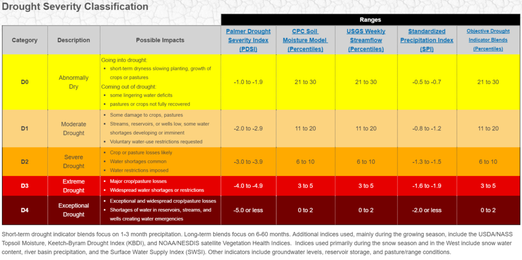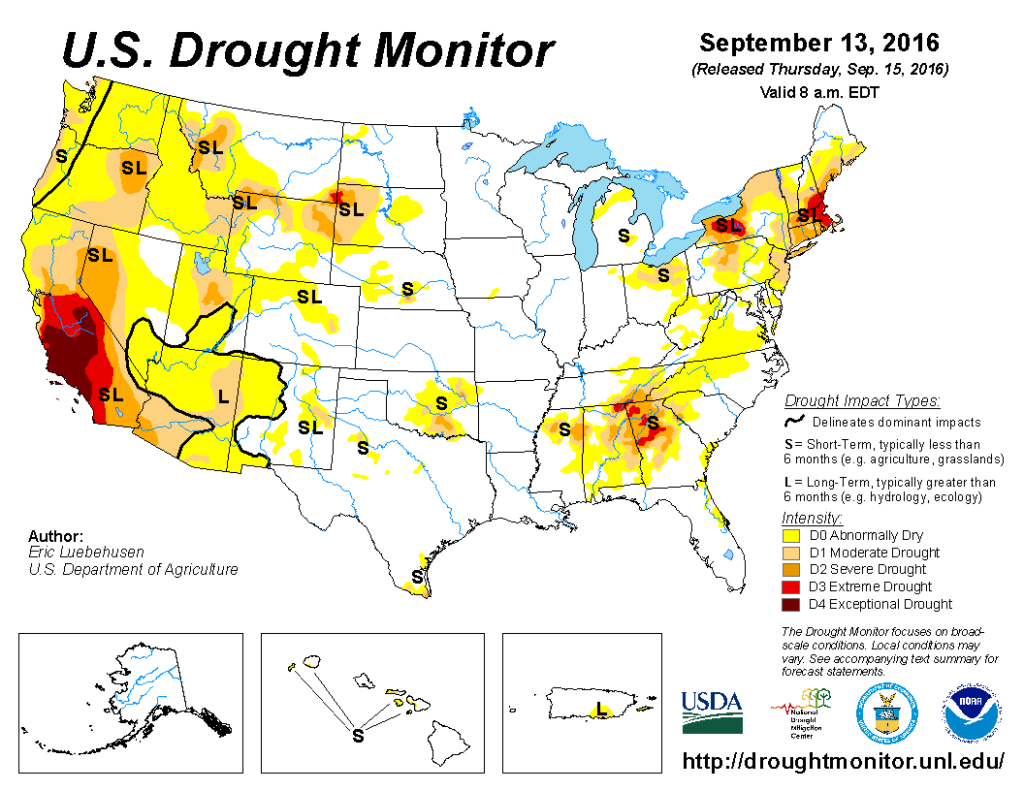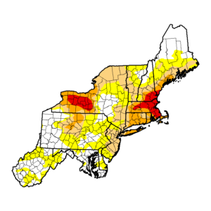
In many parts of the country, drought conditions worsened or remained the same over the last few weeks. In reviewing conditions for the week ending September 13, unseasonably warm, dry weather across the eastern third of the nation contrasted with wet, cooler conditions across portions of the west. The overall trend during this period of time included rapidly expanding dryness and drought from North Carolina into New England, while highly variable drought lingered over much of the Southeast. Recent rain continued to ease dryness in northern portions of the Plains and Rockies as well as the lower Southwest, while drier-than-normal weather intensified in the Pacific Northwest.
With Tropical Storm Hermine doing little to impact the northeast with precipitation over Labor Day weekend, conditions failed to improve in the northeast. Ongoing dryness coupled with unseasonably high temperatures necessitated rapid expansion of Abnormal Dryness (D0) and varying degrees of drought from Virginia into southern New England. Temperatures for the week averaged 5 to 12°F above normal, with daytime highs eclipsing 90°F for much of the week across southern portions of the region. In the expanded Extreme Drought (D3) area, rainfall over the past 6 months has totaled a meager 50 to 60 percent of normal, with most streamflows in the lowest 5th percentile. Farther south, despite a wet signal out to 90 days, 90-degree heat coupled with acute short-term dryness (30-day rainfall totaling less than 40 percent of normal, locally less than 10 percent) led to a widespread expansion of D0 across portions of West Virginia, Virginia, Maryland, Delaware, and southern Pennsylvania. Moderate Drought (D1) likewise expanded over much of New Jersey due to equally low 30-day rainfall values on top of drier-than-normal conditions over the past 60 days. Despite the heat and dryness, heavy downpours (locally more than 2 inches) led to some drought reduction in western Pennsylvania and southwestern New York.
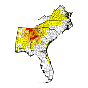
Above-normal temperatures and below-normal rainfall over much of the southern Mid Atlantic continued or expanded dry and drought conditions there. In North Carolina, pronounced late-summer heat (90-94°F) and short-term dryness (30-day rainfall totaling 15 to 40 percent of normal) led to a significant increase of Abnormal Dryness (D0) across the western two-thirds of the state. Farther south, highly variable rainfall over the past 90 days has resulted in a spatially variant drought depiction from Georgia into Alabama and southeastern Tennessee, with 3-month surpluses separated from 4- to 7-inch deficits often by two counties or less.
Rain was concentrated in southern drought-free portions of the South, though showers coupled with additional assessments from the field led to some improvement in drought over northern Mississippi. Over the past 90 days, precipitation has approached 100 percent of normal in north-central Mississippi, where Abnormal Dryness (D0) was removed. Moderate to Severe Drought (D1 and D2) was likewise trimmed in response to this week’s showers, but 90-day rainfall in the remaining drought areas remained well below normal (locally less than 70 percent) .
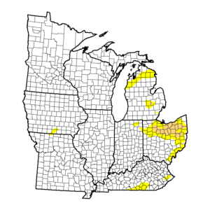
In the Great Lakes region, widespread, locally heavy rainfall led to reductions in drought coverage and intensity, particularly in eastern portions of the region. Rain totaled 1 to 5 inches over northern Indiana and northeastern Ohio, although the remaining Moderate Drought (D1) area is still wrestling with deficits of 2 to 5 inches over the past 90 days. Farther north, this week’s wet weather (1-5 inches, locally more) was sufficient to reduce or eliminate Abnormal Dryness (D0) over eastern Wisconsin and Michigan.
In the eastern Rockies and western Plains, chilly, wet weather improved conditions over the region’s core drought areas, though impacts remained. Temperatures for the week averaged 2 to 8°F below normal, which coupled with widespread rain and high-elevation snow led to reductions of dryness and drought. During the 7-day period, precipitation totaled locally more than an inch in southern and eastern Montana as well as western North Dakota.
This week’s precipitation coupled with a wetter-than-normal period dating back over the past 90 days led to the reduction of Abnormal Dryness (D0) as well as Moderate to Severe Drought (D1 and D2, respectively) in eastern Montana and western North Dakota. Precipitation was also noted in the Black Hills and environs, where satellite-derived vegetation health data as well as reports from the field continued to show improving conditions from this summer’s locally Extreme Drought (D3). Despite the cooler weather and recent rain, impacts lingered in the D2 and D3 areas, with 90-day rainfall remaining locally less than 50 percent of normal.
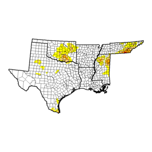
Changes during the week were generally minor in this mostly drought-free region of the Mid-West. Showers eased Abnormal Dryness (D0) and trimmed the Moderate to Severe Drought (D1 and D2) in Nebraska, though deficits over the past 90 days (40-75 percent of normal) lingered. In eastern Colorado, a small pocket of D1 was introduced where 90-day rainfall is currently running one-third of normal. In Oklahoma, locally heavy rain (1-3 inches) and resultant drought relief in central and northern portions of the state contrasted with worsening drought in the south; the state’s new D2 area has received less than 30 percent of normal rainfall over the past 90 days.
Widespread albeit highly variable showers in central and northern portions of Texas contrasted with localized drought intensification in Deep South Texas. Rainfall amounts in Texas’ Abnormally Dry (D0) and Moderate Drought (D1) areas ranged from a Trace to locally more than 2 inches, which likewise resulted in highly variable reduction of D0 and D1. Severe Drought (D2) was introduced in far southern Texas, where 90-day rainfall was less than 25 percent of normal.
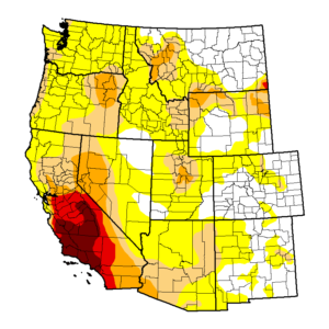
Moderate to heavy rain from former Pacific Hurricane Newton eased or eradicated drought in the lower Southwest, while increasingly dry conditions were noted across portions of the Pacific Northwest. A welcomed soaking rainfall (1-4 inches, locally more) fell over southeastern Arizona and much of southern New Mexico, bringing widespread reductions to Abnormal Dryness (D0) as well as Moderate to Severe Drought (D1 and D2). In some areas, 2-category improvements were made where the rain from Newton was sufficient to push 6-month precipitation to above-normal levels. Further assessment may be warranted over the upcoming weeks to fully incorporate the impacts of this week’s rain on the region’s lingering drought. In contrast, Severe Drought (D2) was expanded across southeastern California and southwestern Arizona due to a poor monsoon (less than 50 percent of normal rainfall over the past 3 months, locally less than 10 percent). Likewise, a small area of Moderate Drought (D1) was introduced in northwestern Washington, where 90-day rainfall has totaled 50 percent of normal (deficits in excess of 2 inches).
The US Department of Agriculture authors the weekly Drought Monitor reports and develops these maps; you can view their full maps and descriptions here: http://droughtmonitor.unl.edu/Home.aspx
