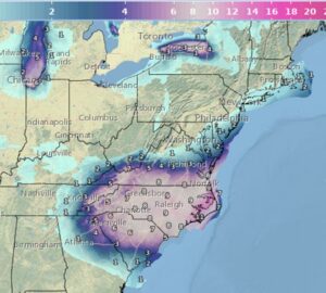
A major east coast snowstorm will likely unfold this weekend, however the impact zone appears to be very limited due to the storm track off-shore. With the threat of heavy snow arriving, the National Weather Service has started to issue Winter Storm Watches for portions of the Mid Atlantic for Saturday into Sunday.
A low pressure system forming in the Southern Plains is forecast to progress through the Gulf coast and into the Southeast by Friday. This is expected to produce a major winter storm for portions of the Mid-Atlantic and Southeast, including the Carolinas, southern Virginia, and the Chesapeake Bay region. By Friday evening and Saturday morning, the low pressure system will move offshore into the Atlantic and traverse northeastward, where it is expected to continue bringing snow into the Mid-Atlantic. This system is also expected to bring strong flow onshore into the East Coast. Where the winds overlap with snowfall, blowing snow and significantly reduced visibility are expected, creating dangerous, near-blizzard conditions across northeast North Carolina and Southeast Virginia. Additionally, strong winds combined with high tides could produce locally significant coastal flooding and damaging waves at the immediate coast.
However, it now appears the storm should track far enough east to spare the heavily populated I-95 corridor between Washington, DC and Boston, MA with any snow. However, just a short distance away south and east along the south Jersey Shore, eastern Long Island, and southeastern New England, snow is expected. While snow will be confined to the coast, this storm system will also have a broad and strong wind field, so even the cities along I-95 free of snow will see strong wind gusts and the coast will see even stronger winds.

Forecast models have come into better consensus at this point and all depict cyclogensis beginning Friday night into Saturday off the southeast coast. This will occur due to a strong upper level disturbance pivoting around the base of the long wave trough over the east interacting with the strong baroclinic zone along the coast. By Saturday evening, the low should be just east of Cape Hatteras and then looks to track northeast from there passing several hundred miles east the mid Atlantic coast on Sunday.
On this type of track, eastern North Carolina should see the heaviest snowfall amounts with more than a foot expected. More than 4″ of snow is expected for the northern half of South Carolina and northeast Georgia. More than 6″ of snow is expected along much of southern Virginia. 3-6″ is likely in eastern Maryland and southern Delaware and Cape Cod and nearby islands of southeastern New England. Lighter snow is expected elsewhere in southeastern New England, Long Island, and central and southern New Jersey.
Had the storm shifted 100 miles west, this would have been an epic blizzard up and down the I-95 corridor with snow measured in feet. A disturbance impacting a ridge of high pressure in the Western U.S. is helping force this east coast system to head more east than north with its track, thereby protecting the heavily populated I-95 corridor with a crippling snowstorm.