• Skip to primary navigation
  • Skip to main content
  • Skip to primary sidebar

Weatherboy

Weatherboy Weather News, Maps, RADAR, Satellite, and Forecasts.

  • Local
  • Earth Science News
  • RADAR
  • Current Warnings
  • Satellite
  • Current Maps
  • Forecast Maps
  • Video

Earthquake Rattles New York; 12th Earthquake in the Northeast Over Last 30 Days

by Weatherboy Team Meteorologist - September 17, 2022

Each dot surrounded by a circle reflects the epicenter of an earthquake over the last 30 days; the earthquake with an additional blue circle is the most recent. Image: USGS


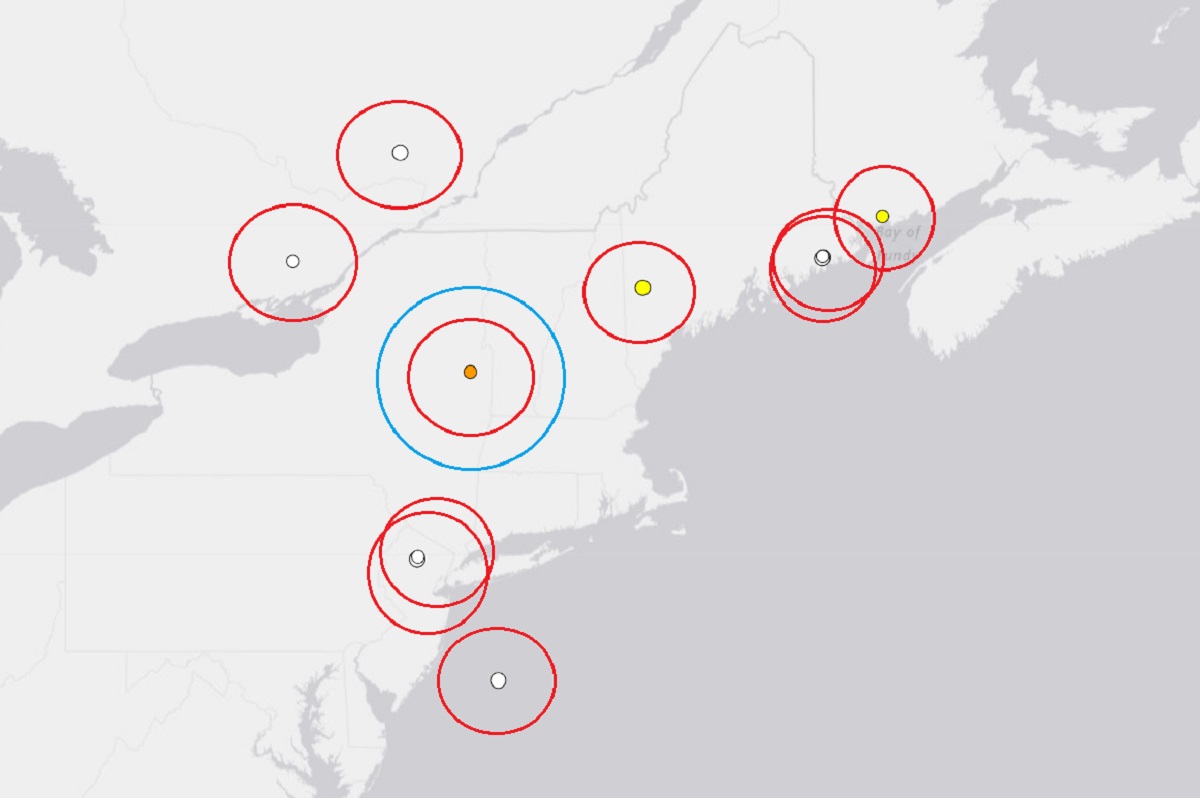
USGS is reporting that an earthquake struck upstate New York north of Albany this morning. At 3:45 am, USGS reported the 12th earthquake to strike the northeast over the last 30 days; this weak seismic event unfolded, rated a magnitude 1.9 event, struck in South Glens Falls just north and east of Saratoga Springs. The earthquake’s epicenter was 10.2 km deep. While the earthquake was measured by seismographs in the northeast, it was likely not strong enough for most people to feel it.

Just yesterday, and earthquake rattled central Maine. Unlike this earthquake in New York today, people thought an explosion had struck in the Maine seismic event, with dozens of people reporting both loud noises and shaking. The Maine quake was rated a magnitude 2.3 event.

The northeast has been rattled by a total of 12 earthquakes in the last 30 days. Maine had 5, New Jersey had 2, one hit off-shore New Jersey, and the rest hit Canada near the U.S. border. The earthquakes have ranged in magnitude from 1.2 to 2.6., with the strongest of the bunch hitting Maine on September 1. While people have felt shaking or heard noises from these seismic events, there have been no reports of injuries.

New York is no stranger to earthquakes; this map shows the epicenter of every earthquake from 1975 to 2017. Image: NESEC


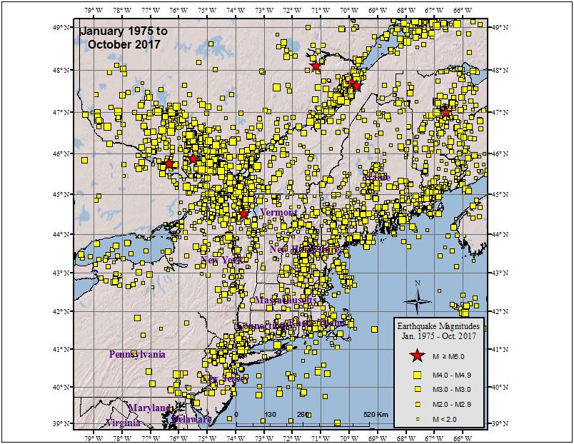
According to the Northeast States Emergency Consortium (NESEC), New York is a state with a very long  history of earthquake activity that has touched all parts of the state.  Since the first earthquake that was recorded in  December 19, 1737, New York has had over 550 earthquakes centered within its state boundaries through 2016. It also has experienced strong ground shaking from earthquakes centered in nearby U.S. states and Canadian provinces.  Most of the earthquakes in New York have taken place in the greater New York City area, in the Adirondack Mountains region, and in the western part of the state.

New York has seen the most number of damaging earthquakes in the northeast in the period 1678-2016. Image: NESEC

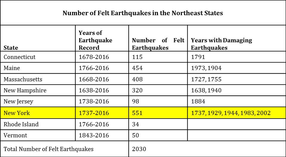
While many of the earthquakes to hit New York are weak like today’s, some have been damaging. Of the 551 earthquakes recorded between 1737 and 2016, 5 were considered “damaging”: 1737, 1929, 1944, 1983, and 2002.

While most of New York’s earthquakes have been in the Upstate, New York City has also seen damaging earthquakes over the years. At about 10:30 pm on December 18, 1737, an earthquake with an unknown epicenter hit New York with an estimated magnitude of 5.2. That quake damaged some chimneys in the city. On August 10, 1884, another 5.2 earthquake struck; this quake cracked chimneys and plaster, broke windows, and objects were thrown from shelves throughout not only New York City, but  surrounding towns in New York and New Jersey too.  The shaking from the 1884 earthquake was felt as far west as Toledo, Ohio and as far east as Penobscot Bay, Maine.  It was also reported felt by some in Baltimore, Maryland.

The earthquakes in the Northeast are not related to a swarm of earthquakes occurring well south and west of this region in an area known as the New Madrid Seismic Zone (NMSZ). Dozens of earthquakes have hit there in recent weeks, with overall earthquake activity reported by USGS to be about 300% above normal this summer in the NMSZ.


Primary Sidebar

Sponsored Ad

Search

Latest News

  • Igloo Cooler Recalled Due to Amputation / Crushing Threat
  • Longtime TV Meteorologist Fired
  • Spacecraft Launched by Soviet Union in 1972 Crashed Back on Earth Today
  • Strong Tennessee Earthquake Reported by 35,000+ People
  • Updated Crash Forecast Puts Eastern U.S. on Alert from Soviet Union Spacecraft
  • Soviet Union Spacecraft Crash Zones Updated; NJ/NY/PA/MI at Increased Risk
  • Over 2,000 People Report Shaking from Virginia Earthquake
  • Morning Earthquake Strikes Heart of New Madrid Seismic Zone in Missouri Today
About | Careers | Contact | Contests
Terms | Privacy | Ad Choices
Weatherboy is a (R) Registered Trademark of isarithm LLC, All Rights Reserved.
All content herein is Copyright by Isarithm LLC 1997-2022