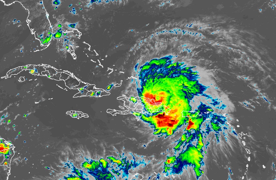
After catastrophic impacts in Puerto Rico yesterday that plunged the island into darkness, the National Hurricane Center says Hurricane Fiona isn’t done yet: the hurricane is set to intensify into a major hurricane and head north, threatening more land as it does so.
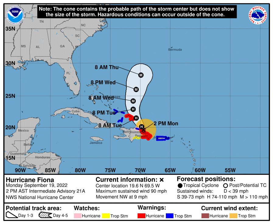
As of the last update from the National Hurricane Center (NHC) in Miami, Florida, Hurricane Fiona was located about 165 miles southeast of Grand Turk Island and had maximum sustained winds of 90 mph making it a Category 1 hurricane on the Saffir-Simpson hurricane wind scale. The storm is moving to the northwest at 9 mph and has a minimum central pressure of 975 mb or 28.79″.
While it’ll take some time to investigate and quantify the full scale of devastation across Puerto Rico, early reports aren’t good. Officials said more than 800 people were scattered in at least 100 shelters around the island before the storm’s flooding rains first hit. In the storm’s early hours, the island encountered an island-wide power failure that remains. Bridges and roadways have washed away as flood waters, rock slides, and mudslides rip through the hilly island. It appears Fiona is the most destructive storm to strike the island since 2017’s Hurricane Maria; it also appears possible that Fiona will shatter rainfall records.
Multiple locations in Puerto Rico recorded more than 20 inches of rain in the 24 hours ending at midnight Sunday. According to the National Weather Service, the Puerto Rico record for 24-hour rainfall is 23.75 inches, set at Toro Negro Forest on October 7, 1985, during the passage of a tropical wave that later became Tropical Storm Isabel. The National Weather Service reported that a site in Adjuntas reported 22″ of rain by early Sunday; rain gauges near Ponce reported 21.09″ too. A rain gauge in Caguas recorded an incredible 27.14 inches of rain in the 24 hours ending at 10:15 am ET Monday, which if confirmed, would set a new 24-hour rainfall record for Puerto Rico.
While Hurricane Fiona will continue to pull away from Puerto Rico, heavy rains will continue to lash the island today. The NHC says an additional 4-8″ of rain, with isolated amounts up to 15″, are possible today, bringing storm totals as high as 20-30″+ on the southern side of the island. On the northern side of Puerto Rico, an additional 1-4″ of rain with isolated amounts of 6″ are possible, producing storm totals of 12-20″.
For now, a Hurricane Warning is in effect for the coast of the Dominican Republic from Cabo Caucedo to Cabo Frances Viejo and the Turks and Caicos. A Hurricane Watch is in effect for the north coast of the Dominican Republic from Cabo Frances Viejo westward to Puerto Plata. A Tropical Storm Warning is in effect for Puerto Rico, including Vieques and Culebra, the north coast of the Dominican Republic from Cabo Frances Viejo westward to Puerto Plata, and for the southeastern Bahamas, including the Acklins, Crooked Island, Long Cay, the Inaguas, Mayaguana, and the Ragged Islands. A Tropical Storm Watch is in effect for the south coast of the Dominican Republic west of Cabo Caucedo to Barahona. A Hurricane Warning means that hurricane conditions are expected somewhere within the warning area. Preparations to protect life and property should be rushed to completion. A Hurricane Watch means that hurricane conditions are possible within the watch area. A Tropical Storm Warning means that tropical storm conditions are expected somewhere within the warning area. A Tropical Storm Watch means that tropical storm conditions are possible within the watch area.

The National Hurricane Center is also warning that interests in Bermuda should monitor the progress of Fiona; the current extended forecast suggests Fiona could approach Bermuda as a dangerous, major hurricane much stronger than when it hit Puerto Rico.
According to the NHC, Fiona should continue moving to the northwest tonight followed by a turn toward the north-northwest on Tuesday and to the north on Wednesday. On the forecast track, the center of Fiona will pass near or to the east of the Turks and Caicos on Tuesday. While maximum sustained winds are near 90 mph with higher
gusts now, strengthening is expected during the next few days, and Fiona is forecast to become a major hurricane by Wednesday with winds of around 125 mph.
While the NHC calls for Fiona to become a major hurricane by Wednesday, it also forecasts the storm to turn more north-northeast then too. While such a path keeps the hurricane well away from the continental United States, it does set the stage for a possible major impact to Bermuda. Even with Fiona on a path away from the U.S. mainland, rough surf and rip currents will likely impact much of the East Coast in the coming days. Swells generated by Fiona are affecting the Virgin Islands, Puerto Rico, the northern coast of Hispaniola, the Turks and Caicos Islands, and the southeastern Bahamas. These swells will continue to spread westward across the southwestern Atlantic toward the central and northwestern Bahamas and the east coast of the United States through midweek. The swells could cause life-threatening surf and rip current conditions and even expert swimmers and surfers are urged to avoid the ocean until Fiona’s threats pass.