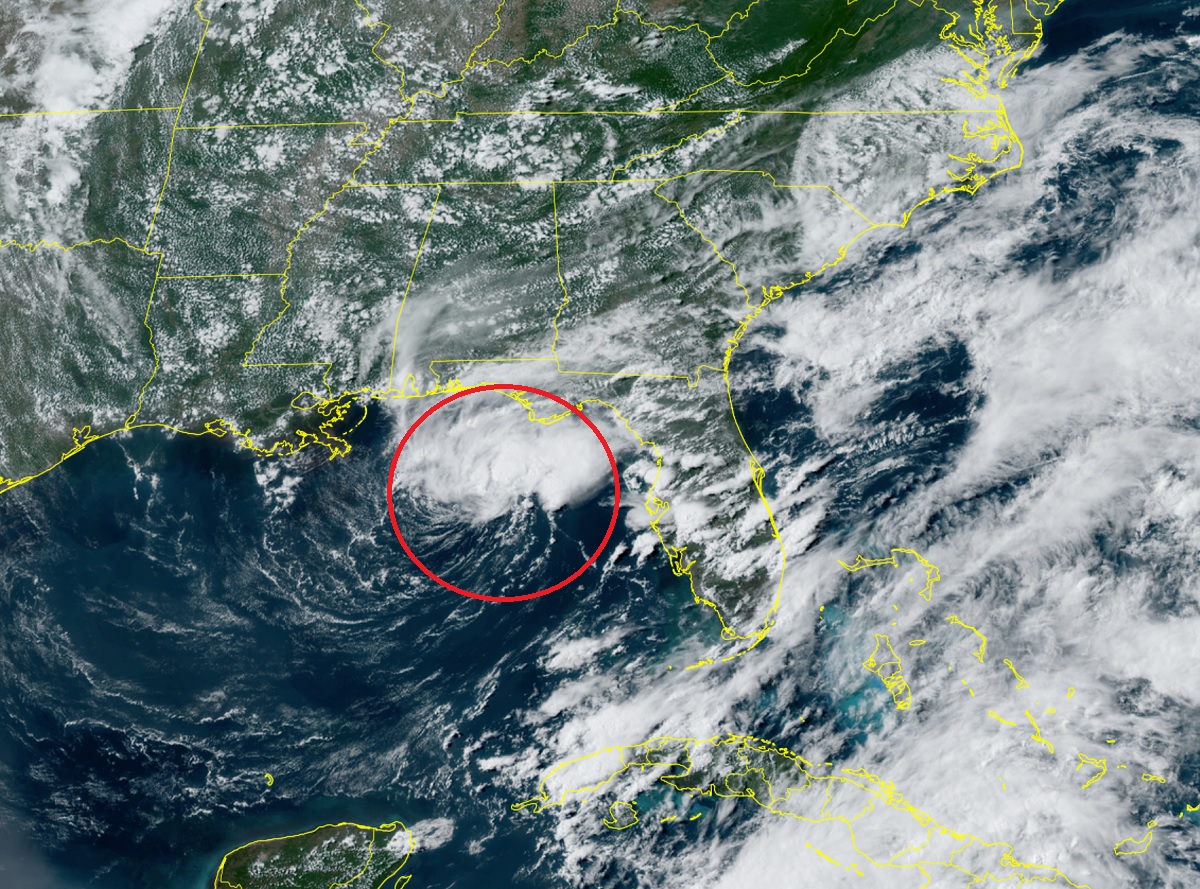
The 2023 Atlantic and Central Pacific Hurricane Season kicked-off today and right on schedule, a new system in the Gulf of Mexico has formed. This new disturbance, now known as Tropical Depression #2, could become Tropical Storm Arlene as it meanders in the Gulf and lashes Florida with heavy rain and gusty winds.
The disturbance was classified as a Tropical Depression due to a variety of observations. Satellite imagery of the Gulf of Mexico from over the past 12-18 hours indicate that an area of disturbed weather that was being monitored by the National Hurricane Center (NHC) became better organized. The NOAA ship Ronald H. Brown passed very near the center earlier today, measuring a distinct wind shift with west-southwest winds just south of the center. And An Air Force Reserve Reconnaissance aircraft that was investigating the system this afternoon identified a closed-off circulation and found flight level winds in the 35-40 kt range to the northeast of the center. Because of these factors, the NHC initiated issuing advisories on Tropical Depression Two, with initial maximum sustained winds of 30 kt or 35 mph.
The NHC says the storm is drifting around in the Gulf of Mexico. Currently, the steering currents over the system are light and variable as the cyclone is positioned directly overhead of an upper-level trough. However as this trough shifts eastward, deep-layer flow out of the north-northwest should begin to move the cyclone slowly to the south or south-southwest with gradually increasing forward motion.
Intensity-wise, the NHC says there is a small window for the system to intensify further over the next 12-24 hours. While westerly shear is quite high with an abundance of dry mid-level air nearby, sea surface temperatures between 26-27 C combined with cold upper-level temperatures are also likely helping to maintain enough thermodynamic instability for moderate to deep convection to persist near the center. For this reason, the latest NHC intensity forecast shows some modest intensification over the next 12-24 hours. However, by Friday night into Saturday, the same northwesterly flow steering the system is also expected to rapidly increase the shear as the system becomes positioned on the upstream side of the upper-level trough, where subsidence may inhibit additional convection. As such, weakening is forecast to begin by Friday night and the latest NHC forecast degenerates the cyclone into a remnant low by Saturday night with dissipation shortly thereafter.
Tropical Depression #2 looks good on satellite and could become Tropical Storm Arlene, the 2nd storm of the season. (The first was unnamed.) pic.twitter.com/ZfJfjf9Wg2
— the Weatherboy (@theWeatherboy) June 1, 2023
The NHC says because the system has a relatively small wind and because it is expected to stay over the open waters of the Gulf of Mexico, no Tropical Storm Watches or Warnings are needed for the Florida coast at this time. However, heavy rain and gusty winds will flow into Florida around this system and the local National Weather Service offices there have issued related Flash Flood products due to flood concerns there.
Should this system become a Tropical Storm, it would be named Arlene. In analysis of the winter months, the National Hurricane Center recently reclassified a disturbance from January as a subtropical storm. That system was technically the first system of the 2023 Atlantic Hurricane Season; because it wasn’t named at the time, the next tropical storm in the basin will get the first name of the season. Forecasters thought it would be too confusing to issue a name to a storm that formed and dissipated months ago.
Beyond this Tropical Depression, the National Hurricane Center doesn’t expect any other system to form over the next 7 days over either the Atlantic or Central Pacific Hurricane Basins.
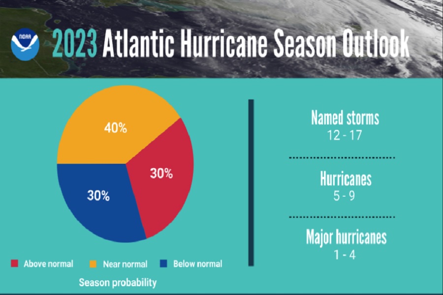
Forecasters are expecting the basins to be busy over the coming months. In the Central Pacific, NOAA forecasters are expecting an above-normal number of tropical cyclones there. Tropical cyclones include tropical depressions, tropical storms, and hurricanes. In the Atlantic, NOAA forecasters are expecting a near-normal season; experts from Colorado State University that lead a tropical outlook endeavor are calling for a near-normal hurricane season in the Atlantic too.
