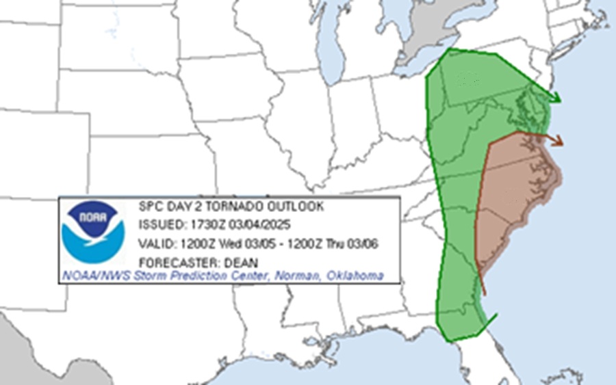
The National Weather Service’s Storm Prediction Center is warning about the possibility of tornadoes from Pennsylvania and New Jersey south to Georgia and Florida for Wednesday. In their latest Convective Outlook, the Storm Prediction Center (SPC) has identified an area along the east coast where there’s an elevated risk of tornadoes. Most people won’t see tornadoes in this area, but the National Weather Service wants to let people know there’s a chance some thunderstorm cells could become tornadic on Wednesday in this area. Beyond tornadoes, there’s also a risk of damaging winds and large hail.
According to the SPC, severe thunderstorms capable of producing scattered damaging-wind gusts and a few tornadoes are possible Wednesday across parts of the eastern Carolinas into southeast Virginia. Other strong to severe storms may occur across parts of Florida and east Georgia, and also from the Allegheny Plateau into the Mid Atlantic. This is because a strong and deep mid/upper-level shortwave trough will move across the eastern continental United States on Wednesday, as an intense occluding cyclone moves northeastward from central Illinois toward the lower Great Lakes region and eventually into southwestern Quebec.
Intense wind fields will support a threat of at least scattered damaging winds with these storms as they move eastward through the day. A strong tornado will be possible, especially if any embedded supercell structures can be sustained in portions of the Mid Atlantic. Other strong to potentially severe storms will be possible from eastern Georgia into the Florida Peninsula, primarily early in the day before the thunderstorm activity moves offshore. On the northern side, from the Allegheny Plateau into the northern Mid Atlantic conditions are expected to remain supportive of organized storms, including potential for a couple supercells and/or organized line segments. Damaging winds, isolated hail, and possibly a tornado or two could accompany the strongest storms across this region, especially during the afternoon and early evening.
It is possible the National Weather Service will issue Severe Thunderstorm and/or Tornado Watches and Warnings on Wednesday as the severe storm threat materializes.
