While many in the northeast continue to dig out of a snowstorm that dumped a widespread 12-20″ of snow, computer models are already suggesting the formation of the next storm which could become a blizzard.
The GFS and ECMWF are among many computer models meteorologists use to assist in weather forecasting. While meteorologists have many tools at their disposal to create weather forecasts, two primary global forecast models they do use are the ECMWF from Europe and the GFS from the United States. While the models share a lot of the same initial data, they differ with how they digest that data and compute possible outcomes. One is better than the other in some scenarios, while the opposite is true in others. No model is “right” all the time. Beyond the ECMWF and GFS models, there are numerous other models from other countries, other academic institutions, and private industry that are also considered when making a forecast.
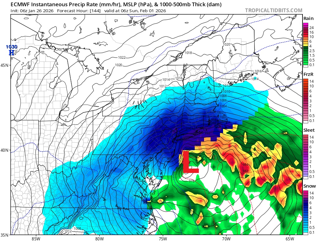
While the most recent winter storm was forming, the GFS (American) forecast model was already projecting a possible coastal storm threat along the east coast; now the ECMWF (European) model is projecting it, giving some meteorologists a pause for concern.
“Deterministic and ensemble guidance continue to show the potential of some sort of system developing off the Mid-Atlantic coast next weekend,” writes the National Weather Service office in Mount Holly, New Jersey, in their latest Forecast Discussion. They add, “Overnight guidance still is all over the place but there is fair agreement in some sort of storm developing. The ECMWF and its AI counterpart are more bullish with the GFS and CMC being different versions of misses or minor storm. GEFS Ensemble Probability of 24 hour snowfall > 4 inches is around 15-20% for the entire area. The NBM probability is similar.” The Mount Holly forecast office is responsible for most of New Jersey, eastern Pennsylvania including the city of Philadelphia, Delaware, and eastern Maryland. “What there is high confidence in is that there will be a cold airmass in place, sufficient for snow. Below normal temperatures will be in place for next weekend, so it will be a matter of IF a storm develops and what the track will be. That will be ironed out over the coming days,” the National Weather Service office concludes.
Beyond calling for a coastal snowstorm, computer forecast models are also suggesting the system would produce blizzard conditions for Delaware, New Jersey, New York, Connecticut, Rhode Island, Massachusetts, and portions of Pennsylvania. There is a clear difference between a winter storm, like the one that just hit the northeast, with a blizzard. A blizzard is a severe winter storm defined by sustained winds or frequent gusts of 35 mph or greater, accompanied by heavy falling snow or blowing snow that reduces visibility to less than 1/4 mile. These intense conditions must persist for at least three consecutive hours to be officially classified as a blizzard. The computer forecast models suggest a deep storm system and a steep pressure gradient that would create strong winds over a prolonged period of time. While blizzards don’t have an accumulation or snow amount metric they need to achieve, model guidance suggests an abundance of snow which would easily blow about in those winds. As a result, blizzard criteria would be met –if the storm materializes.
Whether or not the storm materializes and where it does remain big questions. As the National Weather Service points out, not all models and their subsequent runs are in alignment to a blizzard outcome. Some forecast model output suggests while the ingredients for a big snowstorm will be there, they may come together too late and too far off-shore, sparing the east coast from significant snow and wind. Another day or two of data reviews, atmospheric sampling and modeling, and analysis will be needed to determine whether or not this storm will actually materialize.
