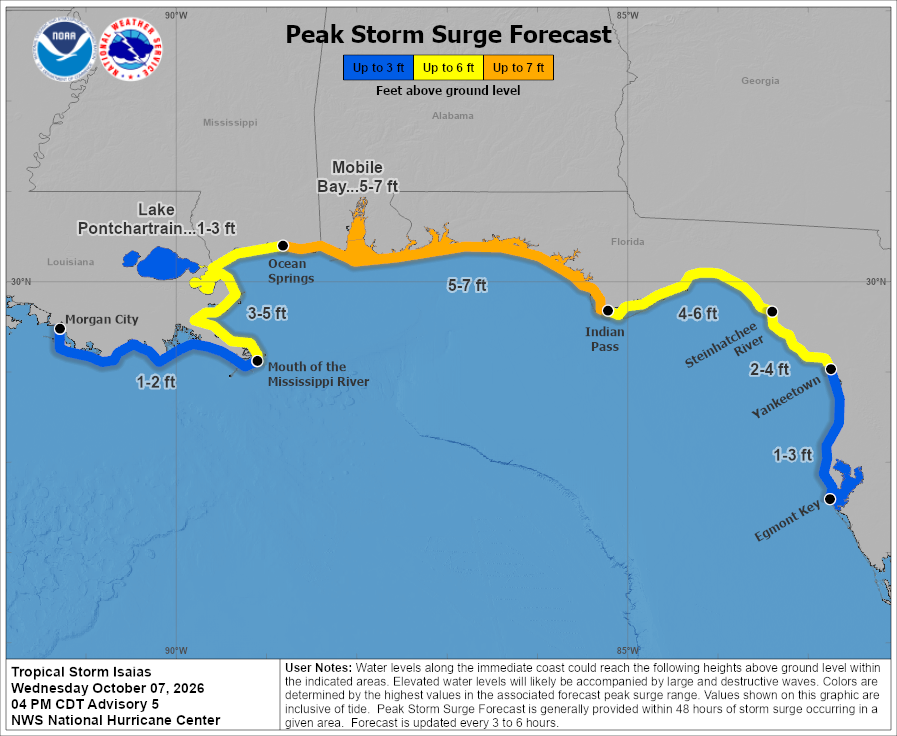
The National Hurricane Center is warning of the potential for a very significant storm surge which is forecast to strike portions of the central Gulf of America coast as Isaias moves inland as a strong hurricane. Because of the threat, Storm Surge Watches have been issued along with Hurricane Watches by the national Hurricane Center (NHC).
Tropical Storm Isaias formed early today and is expected to become a hurricane tonight. The National Hurricane Center is urging people in the forecast impact zone to take immediate steps to protect life and property ahead of the storms arrival.
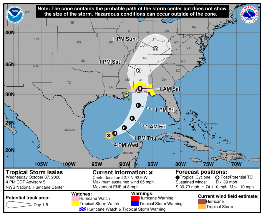
For now, the National Hurricane Center has issued a Storm Surge Watch from the Mouth of the Mississippi River to Yankeetown, Florida. A Hurricane Watch is in effect for Bay St. Louis to Indian Pass and a Tropical Storm Watch is in effect for Jefferson/Plaquemines Parish line to west of Bay St. Louis and for the area east of Indian Pass to Aucilla River.
A Storm Surge Watch means there is a possibility of life-threatening inundation, from rising water moving inland from the coastline, in the indicated locations during the next 48 hours.
A Hurricane Watch means that hurricane conditions are possible within the watch area. A watch is typically issued 48 hours before the anticipated first occurrence of tropical-storm-force winds, conditions that make outside preparations difficult or dangerous.
A Tropical Storm Watch means that tropical storm conditions are possible within the watch area, generally within 48 hours.
The National Hurricane Center warns, “Additional watches and warnings could be required for a portion of the U.S. northern Gulf coast later today.”
As of the latest advisory from the National Hurricane Center, Tropical Storm Isaias was located near latitude 22.7 North, longitude 92.9 West. This places Isaias about 500 miles south-southwest of the Mouth of the Mississippi River.
The storm is moving toward the east-northeast near 8 mph . A continued east-northeastward motion is expected by the NHC today, followed by a turn toward the northeast and north on Thursday and Friday. On the forecast track, Isaias is expected to pass to the north of the Yucatan Peninsula on Thursday and make landfall along the U.S. northern Gulf Coast late Friday or early Saturday.
Maximum sustained winds are near 65 mph now with higher gusts. The NHC says Isaias is forecast to become a hurricane by Thursday morning with further strengthening expected through Friday morning.
The National Hurricane Center is sharing these 4 key messages ahead of the storm:
- Isaias is expected to strengthen and be a strong hurricane when
it approaches the northern Gulf Coast on Friday. There is an
increasing risk of life-threatening storm surge along portions of
the northern Gulf Coast, and a Storm Surge Watch is in effect from
The Mouth of the Mississippi River to Yankeetown, Florida. Residents
in the watch area should follow advice given by local officials and
evacuate if told to do so. - The risk of damaging hurricane-force winds is increasing over portions of the Florida Panhandle, southern Alabama, and southern Mississippi. A Hurricane Watch has been issued from Bay St. Louis, Mississippi, to Indian Pass, Florida. Residents in these areas should prepare for the possibility of long-duration power outages.
- Isaias will bring areas of heavy rainfall to the central U.S. Gulf Coast and much of the Southeast Friday into the weekend. Flash and urban flooding, along with isolated river flooding, will be possible.
- Isaias could bring gusty winds and areas of heavy rain to the western portion of the Yucatan Peninsula through Thursday.
The combination of a dangerous storm surge and the tide will cause normally dry areas near the coast to be flooded by rising waters moving inland from the shoreline. The water could reach significant heights if the peak surge occurs at the time of high tide. Those heights include 5-7 feet from Ocean Springs, Mississippi to Indian Pass, Florida and all of Mobile Bay, 4-6 feet from Indian Pass, Florida to Steinhatchee River, Florida, 3-5 feet from the Mississippi River to Ocean Springs, Misssissippi, and 2-4 feet from from Steinhatchee River, Florida to Yankeetown, Florida. Across Lake Pont Pontchartrain a 1-3 foot storm surge is possible. The deepest water will occur along the immediate coast near and to the east of the landfall location, where the surge will be accompanied by large and dangerous waves. Surge-related flooding depends on the relative timing of the surge and the tidal cycle, and can vary greatly over short distances.
Isaias is expected to produce rainfall amounts of 1 to 3 inches through Thursday across coastal portions of the eastern Bay of Campeche with isolated higher amounts possible in the states of Campeche and western Yucatan. From Friday through the weekend, the system is expected to produce rainfall amounts of 3 to 7 inches, with localized totals up to 10 inches, across the central U.S. Gulf Coast extending from far southeastern Louisiana to the Florida Panhandle. Rainfall amounts of 1 to 3 inches, with localized amounts up to 5 inches, are possible across much of the Southeast as far north as the Tennessee Valley and the Carolinas. Flash and urban flooding, along with isolated river flooding, will be possible.
The tornado potential will increase as rain bands accompanying Isaias approach the northeastern Gulf Coast Friday evening and overnight. This potential will spread inland on Saturday as Isaias continues northward.
Swells are expected to affect the western and northern portions of the Yucatan Peninsula beginning on Thursday and spread northward toward the Gulf Coast late this week. These swells are likely to cause life-threatening surf and rip current conditions.
Satellite and aircraft data show that Isaias continues to strengthen. GOES-19 imagery indicates that a central dense overcast has formed, and the system has become more symmetric than this morning. As a result, the forecast calls for Isaias to become a hurricane this evening.
