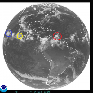
After a busy few days with a number of named storms in the Pacific and Atlantic hurricane basins, things are slowing down with Tropical Storms Don and Greg and Hurricane Fernanda all weakening.
Overnight, the system that was once Tropical Storm Don degenerated into an open wave. Without an organized tropical cyclone there, the National Hurricane Center will stop issuing advisories on it. An Air Force Reserve reconnaissance aircraft made several passes through the system last night and was only able to find a sharp wind shift–but no winds with a westerly component. With no center of circulation, the National Hurricane Center declared Don an open wave. However, based on the aircraft data, the disturbance is still producing gusty winds of about 35 knots west of the Windward Islands over the far southeastern Caribbean Sea. While this system has degenerated into an open low, residents and visitors of Aruba, Bonaire, and Curacao should continue to monitor this system; heavy showers with gusty winds may occur as the remnants of Don move nearby this week.
In the Pacific, Fernanda is still a hurricane but is weakening. Fernanda’s convective cloud pattern has continued to wither and has been accompanied by a general warming of the cloud tops. The eye is no longer evident in infrared imagery and an analysis early this morning by the National Hurricane Center indicated that the eye had become open in the southern semicircle. Fernanda is forecast to move northwestward today and turn toward the west-northwest by tonight or Thursday. A continuation of that general motion is expected through the end of the forecast period due to a strong subtropical ridge remaining entrenched to the north and northeast of the Hawaiian Islands. As of early this morning (East Coast time), Fernanda was located about 1,330 miles east of Hilo on the Big Island of Hawaii.
Also in the Pacific, Tropical Storm Greg is weakening.Although the initial intensity is a little lower than the previous advisory, the National Hurricane Center says most of the forecast guidance available to them still suggests that Greg will gradually strengthen within a warm sea surface temperature, high-moisture, low-shear environment for the next 24-36 hours. However, Tropical Depression #8 is nearby; if it becomes the dominant cyclone in the area, Greg will dissipate much sooner than currently forecast.