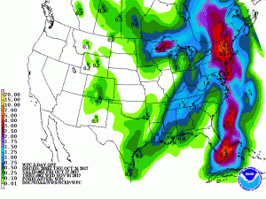
A potent coastal storm is set to bring wind and rain to the northeast on the fifth anniversary of Hurricane Sandy’s impacts on the United States. While portions of the northeast, especially New Jersey and New York, were hit hard by what was left of Sandy in 2012, while potent, the coastal storm expected this weekend will be nothing like the historic storm it’ll share a date with.

The National Weather Service’s Weather Prediction Center believes more than a half-foot of rain could fall over portions of New England over the next 5 days, with most falling between Sunday and Monday. 2″ or more could fall over Philadelphia, New York City, and Boston metro regions. Heavy rain over a relatively short period could create flooding conditions, especially in the hilly or mountainous terrain of New England where rain water will rush through valleys.
Beyond heavy rain, strong winds are expected too. Widespread wind gusts of 25-40mph are possible, with higher gusts likely at the shore. The worst winds should be from northern New Jersey north into New England. Trees that haven’t lost their leaves to autumn yet may be stressed under the winds, creating some limbs to fail. Falling trees and limbs could topple power lines, resulting in power outages to some, especially over New England.
Rain will slide in from the west on Saturday, reaching the coast by Saturday night. While a frontal system will be responsible for the initial push of rain, eyes will be on an area with tropical origins that’ll be racing up the US/Atlantic coast. This disturbance will join forces with the frontal system, producing a wind-whipped rain storm for the northeast on Sunday. Rain will be heavy at times in eastern Pennsylvania, New Jersey, Delaware, New York, and all of New England by the afternoon hours on Sunday. Heavy rain will continue into early Monday before wrapping-up from southwest to northeast during the morning hours at the start of the new work week.
Depending how the ingredients come together and when/where, there could also be strong thunderstorms for some. The best chance of thunderstorm development will be over central Pennsylvania and New Jersey and points north into central New England. People in this region should remember that lightning can kill in any season; when thunder roars, they should head indoors.
By Monday night, winds will diminish and high pressure will move into the Northeast. Temperatures will return to near or slightly below average values. Temperatures will fall further when a dry, weak cold front pushes through the northeast on Monday night. While starved for moisture and/or energy, this system will help usher in some of the coldest readings of the season into the Mid Atlantic and Northeast Tuesday night.