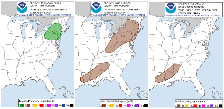
A typical spring weather-set up of clashing warm and cold air will produce severe weather across a large part of the eastern United States this afternoon and evening. Some areas within the east have an elevated threat of tornadoes, damaging winds, and large hail. A warm front will lift through the Mid Atlantic today as a strong low
pressure system moves from the Great Lakes this morning to eastern Canada tonight. A cold front extending southwestward from this low will sweep through the Eastern Seaboard tonight. As this front moves through, thunderstorms will develop. Many will be strong and some could be severe.
Today’s severe weather threat impacts two areas: one in portions of the northeast, another over portions of the south. In the northeast, a threat of isolated tornadic cells exists over portions of New Jersey, Pennsylvania, and New York. A broader area could be susceptible to damaging wind gusts; those area include where there’s a risk of tornadic cell and expands to portions of Vermont, New Hampshire, Massachusetts, Connecticut, Maryland, West Virginia, Ohio, and Kentucky. In the south, there’s a threat of damaging winds too over portions of Texas, Louisiana, Alabama, Mississippi, and Georgia. In this same area in the south, a threat of large hail exists too.
People in all of these risk areas should prepare for the possibility of severe weather. While not everyone will see a thunderstorm, and even fewer will see severe storms, it is important that people remain weather-aware and storm-ready. Even in situations where people are under quarantine or in a shelter-in-place zone , they should identify places to stay safe and secure should severe weather strike their location.
The greatest threat of severe weather will exist between 3pm and 9pm ET today.