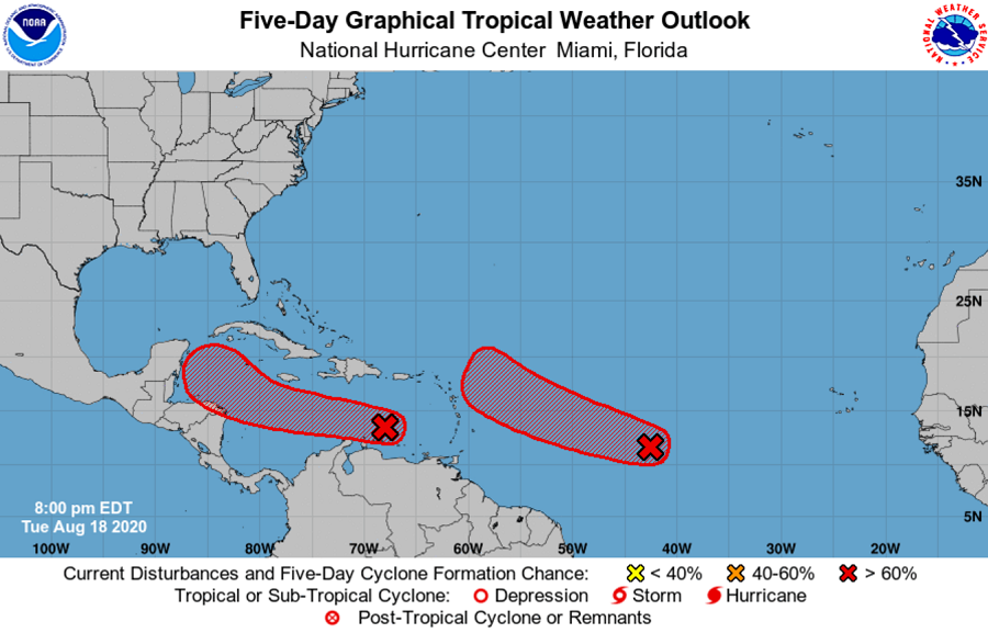
The National Hurricane Center in Miami, Florida has been monitoring two areas of disturbed weather in the tropical Atlantic; this evening, they say it’s likely both will blossom into tropical cyclones in the coming days. With the next two names on the list of 2020 Atlantic Hurricane Season names up being Laura and Marco, it’s possible each system will earn these names by the weekend. If they do get named, they will be the earliest “L” and “M” storms on record; the earliest such storms were named before were August 29 and September 2.
The closest system is a tropical wave located over the eastern Caribbean Sea. For now, it is producing a large area of cloudiness and disorganized thunderstorms along with strong gusty winds on its north side. While the National Hurricane Center says significant development of this system is unlikely during the next day or so, the wave is forecast to move more slowly by the end of the week and a tropical depression is likely to form when the system reaches the northwestern Caribbean Sea. The National Hurricane Center says there’s a medium chance that something will happen here within the next 48 hours, but those odds grow to a high 80% over the next 5 days.
The second system is the most likely to develop into a tropical cyclone next. Currently, the area in question consists of a broad and elongated area of low pressure located about 1,000 miles west-southwest of the Cabo Verde Islands. Tonight, it continues to produce a concentrated area of showers and thunderstorms on its west side. The National Hurricane Center says environmental conditions are conducive for further development, and a tropical depression is expected to form during the next day or two while the system moves generally west- northwestward at 15 to 20 mph across the central and western portions of the tropical Atlantic. The National Hurricane Center believes there’s a 90% chance that this system will develop into a tropical cyclone within the next 48 hours.
With both systems forecast to move to the west with time, it is possible they could each bring direct or indirect impacts to the United States coast. The more western system could be a Gulf of Mexico threat while the eastern system could be more of a U.S. East Coast threat. It is too soon to say with certainty where each system will go with time.

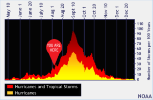
In recent days, experts with Colorado State University’s (CSU) Tropical Meteorology Project and NOAA have each released updated hurricane season outlooks reflecting an even busier expected outcome for an already forecast busy season. The CSU outlook update is calling for an additional 5 major hurricanes in the coming weeks while the NOAA update is now calling for more tropical storms and hurricanes than they have ever forecast in any year before.
The 2020 Hurricane Season has been a busy one in the Atlantic, with the most number of named storms so early in the season. According to CSU’s Dr. Phil Klotzbach, “The Atlantic has already generated 25.75 named storm days in 2020 –the third most in the satellite era since 1966 through August 14.” He adds, “The only years with more named storm days through August 14 were 2005 with 39.75 named storm days and 2008 with 29 named storm days”.

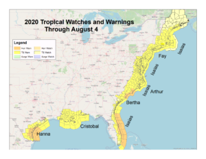
With so many threats to the United States already, much of the coast has been under a Tropical Storm or Hurricane Watch or Warning already. Even Hawaii has already been warned this year, which was threatened by Hurricane Douglas just weeks ago. A map produced by the Corpus Christi, Texas National Weather Service office shows the entire U.S. East Coast and much of the western and central Gulf Coast has seen tropical cyclone watches and warnings issued at least once by August 4.
With so many storms and advisories out already, and the ongoing impacts of the COVID-19 global pandemic, experts are concerned that disaster fatigue may be setting in and may not be as prepared as they should for what is likely to be a very active period in the tropics in the coming months.
“We have to be open and honest about the challenges that people face, ” Mike Brennan, Ph.D., told us; he serves as Senior Hurricane Specialist at the National Hurricane Center. “And we need to remind people that the situation of where they lived in June may be different from what it’s going to be related to COVID when the next storm arrives in September. Pay attention to that local situation and your local emergency managers –those are the people that will tell you what you need to do to be prepared for the hurricane in the COVID environment where you live.”
“Repetitiveness of storms becomes an issue, ” says Dr. Uccellini, Director of the National Weather Service. We asked Dr. Uccellini for his thoughts on disaster fatigue and what they’re doing to keep people informed and safe. “We need to be persistent in our messaging. It’s really important that communities don’t let their guard down.” Dr. Uccellini also said this is a “whole community effort, not just the National Weather Service, but one that involves the whole weather enterprise.” Dr. Uccellini says players across the weather enterprise need to rally around a consistent message to “ensure communities don’t let their guards down.” Even with multiple disasters impacting the United States, Dr. Uccellini said it’s important that everyone “be ready and responsive” for what lies ahead.
To be prepared, the weather enterprise is encouraging that everyone to have a Hurricane Action Plan, even if they were already impacted by a tropical cyclone this year. Due to COVID-19, people should also factor the pandemic in their planning and think about extra supplies they may need or restrictions they may encounter when executing a plan or evacuating an area from a hurricane threat. A good Hurricane Action Plan details what you’d do before a hurricane or tropical storm arrives, what you’d do during impact, and what you would do in a storm’s wake.