• Skip to primary navigation
  • Skip to main content
  • Skip to primary sidebar

Weatherboy

Weatherboy Weather News, Maps, RADAR, Satellite, and Forecasts.

  • Local
  • Earth Science News
  • RADAR
  • Current Warnings
  • Satellite
  • Current Maps
  • Forecast Maps
  • Video

Arthur Churns Off Mid Atlantic Coast

by Weatherboy Team Meteorologist - May 18, 2020

The latest visible satellite image from the GOES-East weather satellite shows Arthur spinning about due south of New York City. Image: NOAA
The latest visible satellite image from the GOES-East weather satellite shows Arthur spinning about due south of New York City and east of North Carolina. Image: NOAA


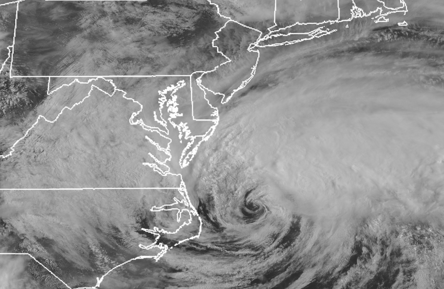
With Tropical Storm Arthur moving away from the Mid Atlantic coast, the National Hurricane Center has dropped all Tropical Storm Warnings that were in effect for North Carolina. As of 5pm ET,  the center of Tropical Storm Arthur was located near latitude 36.1 North, longitude 73.9 West. Arthur is moving toward the northeast near 16 mph. According to the National Hurricane Center, a turn toward the east-northeast is expected tonight, followed by a turn toward the east on Tuesday. A slower southeast or south-southeast motion is expected to begin Tuesday night and continue through Wednesday. On the forecast track, the center of Arthur will continue to move away from the east coast of the United States, approach Bermuda, and recurve closer to the United States again albeit in a weakened form.

Latest official forecast track for Tropical Storm Arthur. Image: NHC

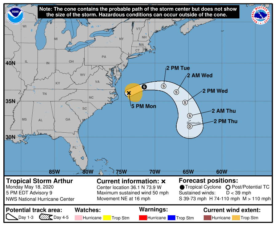
Maximum sustained winds are near 50 mph with higher gusts. While some strengthening is forecast by the National Hurricane Center during the next 24 hours, Arthur is likely to lose its tropical characteristics late by tonight or Tuesday. Tropical-storm-force winds extend outward up to 115 miles. The estimated minimum central pressure is 993 mb or 29.33 inches. The only Atlantic named storms with lower pressure in May in the past 40 years are 2012’s Beryl  and 2018’s Alberto.

While the storm is moving away from the Mid Atlantic coast, there are still hazards impacting the U.S..  Swells generated by Arthur are expected to affect portions of the mid-Atlantic and southeast U.S. coasts during the next day or two; these swells could cause life-threatening surf and rip current conditions.  People heading to beaches that may be open during the pandemic should exercise extreme caution due to these hazards around the water.


Primary Sidebar

Sponsored Ad

Search

Latest News

  • 300+ Earthquakes Rock Caribbean, Still No U.S. East Coast Tsunami Threat
  • Atlantic Hurricane Basin Quiets with 4 Weeks of Season To Go
  • Quake Rattles Heart of New Madrid Seismic Zone in Missouri
  • Halloween Earthquake Rattles Alabama
  • Hurricane Melissa Moves Away from Bermuda; Expected to Become Extratropical Today
  • Potent Storm to Impact New Jersey, Pennsylvania, Delaware, and New York
  • Ongoing Strong Caribbean Earthquakes Serve as Reminder to East Coast Tsunami Threat
  • MELISSA MAKES LANDFALL AS ONE OF STRONGEST ATLANTIC HURRICANES EVER
About | Careers | Contact | Contests
Terms | Privacy | Ad Choices
Weatherboy is a (R) Registered Trademark of isarithm LLC, All Rights Reserved.
All content herein is Copyright by Isarithm LLC 1997-2022

Insert/edit link

Enter the destination URL

Or link to existing content

    No search term specified. Showing recent items. Search or use up and down arrow keys to select an item.