
Tropical Storm Fernand is spinning about in the Atlantic Ocean and is of no threat to the U.S.; beyond that, the National Hurricane Center says there are no other tropical cyclone threats in the Atlantic and they don’t expect any to pop up for at least the next 7 days.
As of the last update from the National Hurricane Center, the center of Tropical Storm Fernand was located about 360 miles east-northeast of Bermuda. Fernand is moving toward the north-northeast near 12 mph and this motion is expected to continue for the next day or so, followed by a turn to the northeast. On the forecast track, Fernand should move across the open waters of the subtropical central Atlantic well east and northeast of Bermuda and well away from the U.S. East Coast and Canada. Maximum sustained winds are near 50 mph with higher gusts. The National Hurricane Center says some strengthening is possible today, but weakening is expected to begin tonight, and Fernand is expected to become post-tropical on Wednesday.
A tropical wave over the eastern Caribbean Sea is producing disorganized showers and thunderstorms. Originally thought to be a potential U.S. threat, this system has become even less organized than it was yesterday and further development is not anticipated as it moves quickly westward during the next few days. In their latest Tropical Outlook, the National Hurricane Center says there’s a near-zero percent chance that this will evolve into a tropical cyclone.
Elsewhere, the Atlantic Ocean is very quiet with no other tropical depressions, tropical storms, or hurricanes. Nor are any expected; the National Hurricane Center says no new tropical cyclones are expected to form anywhere in the basin over the next 7 days.
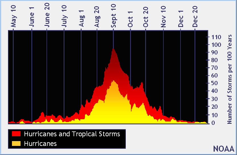
September 10 is the traditional peak of the Atlantic Hurricane Season which stretches from June 1 through to November 30.
The last storm of the season was Hurricane Erin, a very large Category 5 hurricane that brought rough surf and storm surge flooding up the U.S. East Coast, but no direct impacts nor landfall.
