A powerful nor’easter will slide up the east coast, burying some areas with snow that will be measured in feet rather than inches. This blizzard bomb will be just that: an area of low pressure that is due to meteorologically “bomb” while blizzard criteria is expected to be reached over a rather broad area.
While many people think a blizzard is simply a big snowstorm, they’re wrong. A blizzard is all about wind and visibility. According to the National Weather Service, three criteria must be reached before a storm is considered a blizzard. First, there needs to be sustained winds of 35 mph or frequent gusts over 35 mph. Second, due to the weather, the visibility must be reduced to 1/4 mile or less. This reduction can happen from falling heavy snow …or it could simply be previously fallen snow blowing about in the wind. You do not need fresh snow to be falling to reach blizzard criteria. Third, to count as a blizzard, the reduction in visibility and the strong winds must last for at least three hours. When all three of these conditions are met, you have more than a snowstorm: you have a full-fledged blizzard!
For this storm, blizzard conditions are possible along Delaware beaches, the Jersey Shore, Long Island, and southeastern New England. The worst blizzard conditions with the highest winds are likely over extreme southeastern New England at/around Cape Cod.
A “bomb cyclone” refers to the meteorological process of explosive cyclogenesis. Similar to a rapidly intensifying hurricane in the tropics in hurricane season, a bomb cyclone refers to a storm and a process in which atmospheric pressure drops quickly, the storm intensifies, with wind and precipitation increasing. In general, a bomb cyclone is a storm system that experiences a drop of at least 24 millibars (mb) within a 24 hour period.
Currently both the GFS and ECMWF global forecast models do suggest a bombing cyclone this weekend. The GFS and ECMWF are among many computer models meteorologists use to assist in weather forecasting. While meteorologists have many tools at their disposal to create weather forecasts, two primary global forecast models they do use are the ECMWF from Europe and the GFS from the United States. While the models share a lot of the same initial data, they differ with how they digest that data and compute possible outcomes. One is better than the other in some scenarios, while the opposite is true in others. No model is “right” all the time. Beyond the ECMWF and GFS models, there are numerous other models from other countries, other academic institutions, and private industry that are also considered when making a forecast.

Both of these global forecast models are projecting a major winter storm will unfold this weekend, however significant differences remain with how these models are factoring in the phasing of northern and southern stream disturbances. The timing and location of that phasing sets the stage for storm intensity and path amd both global models suggest different impacts for the northeast, with the European model calling for a more robust, impactful storm than the GFS.
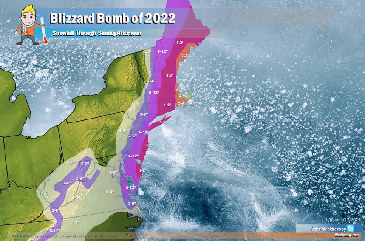
While heavy snow and strong, potentially damaging winds will impact the coast, not much snow is expected to fall far inland. Little to no snow at all is expected for places like Burlington, Vermont, Albany, New York, and State College, Pennsylvania from this system. A very sharp cut-off will exist on the back side of this storm where no snow will fall, with significantly heavier amounts expected a short distance east of there.
The I-95 cities will see different impacts, with far less snow expected west and north of I-95 and far more expected east of it. In Washington, DC, 1-3″ is forecast while Philadelphia and New York City could see 6-12″. Hartford and Stamford will both see around a foot or more while Providence is expected to be near 2 feet, as will Boston. Boston’s southern suburbs and portions of Cape Cod will exceed 2 feet, with some 3 feet+ totals possible too.
The higher terrain of West Virginia and the North Carolina mountains will also see somewhat heavier snow amounts, but most of the heavy snow will be confined to the east coast.

New Jersey is a great illustration of how dramatic the gradient of snowfall will be; some parts of the state in the northwest will only see 1-3″ of snow while portions of the Jersey Shore could see more than a foot of snow.
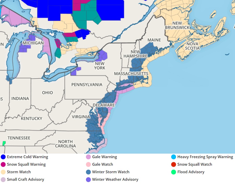
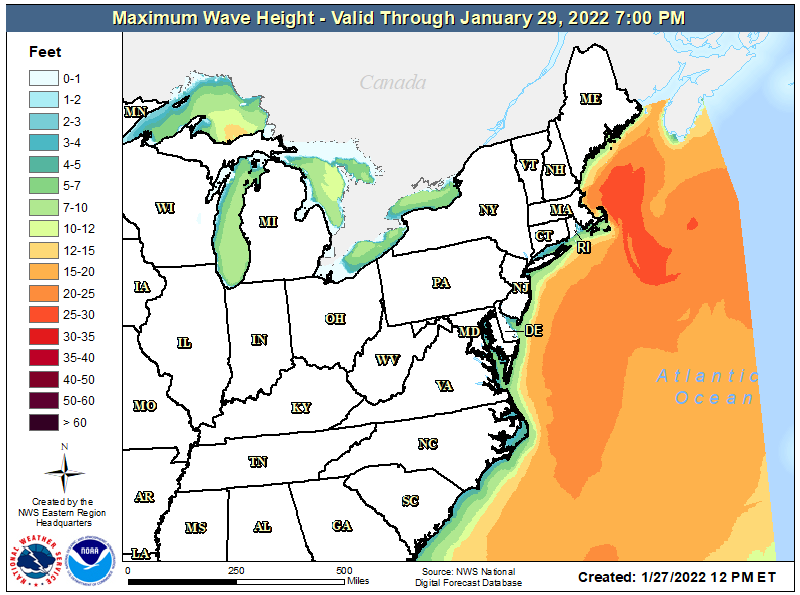
Gale Warnings and Watches and Storm Watches are also up for coastal waters. Winds and waves at the coastline will be rough, with coastal flooding and significant beach erosion possible from eastern Virginia north. The greatest threat of coastal flooding will be along the southeastern New England coast.
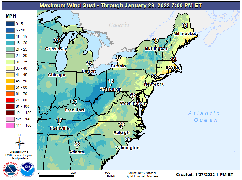
While gusty winds are expected even inland, the worst of the winds will be at the coast. Winds gusting 30-50 mph will be possible at the coast, with the highest winds expected over eastern Massachusetts, Rhode Island, and Long Island. The strong winds will help fuel blizzard conditions at the immediate coast, at least at times, from Delaware Beaches and the Jersey Shore north to the coast of Maine.

While the storm will begin to crank up late Friday, most of the snow will fall on Saturday from southwest to northeast.
Snow should break out over portions of Virginia, North Carolina, and West Virginia as early as 10 pm Friday night. Snow should start by midnight tomorrow night in Philadelphia and Atlantic City, with New York City soon after. Heavy snow should begin in Boston and southeastern New England by 4am. The heaviest snow over Delaware and New Jersey should be wrapped up by lunchtime Saturday, with the heaviest snow wrapping up over southeastern New England by dinner time Saturday. Snow will begin to diminish by 3am across Maine, with all snow from this storm out of the U.S. by breakfast time Sunday morning.
Strong winds will persist over New England in the wake of the storm, with blowing and drifting snow likely there. Even after the snowfall stops, blizzard conditions will be likely into early Sunday as winds whip up fresh snow, blowing and drifting it while reducing visibilities.