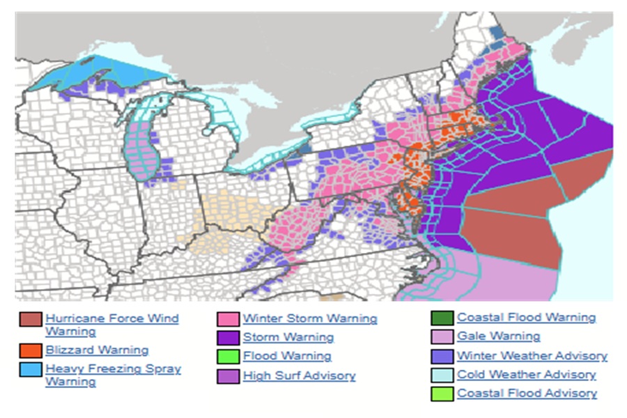
Blizzard ’26 is arriving and it looks even worse than initially thought, forcing the National Weather Service to expand the area under a Blizzard Warning and even issuing a Hurricane Force Wind Warning for nearby off-shore waters. Where a Blizzard Warning isn’t, a Winter Storm Warning is with the expectation of very heavy snow even away from the coast where snow will be measured in feet instead of inches. A blizzard is defined by the National Weather Service as a severe winter storm lasting 3 hours or longer with sustained winds or frequent gusts of 35 mph or greater and considerable falling or blowing snow that reduces visibility to less than 1/4 mile. A blizzard is distinguished from a regular snowstorm by wind speed and visibility and not by snow accumulations.
The last time a Blizzard Warning was issued for the New Jersey shore was 2022, where blizzard conditions were verified for Atlantic and Cape May counties along with portions of coastal Monmouth and Ocean counties. For New York City, the last time a Blizzard Warning was issued there was March 2017.
A major winter storm, perhaps a historic one, is expected to develop today, impacting the northern Mid Atlantic and the Northeast with very heavy, crippling snowfall and areas of blizzard conditions. Precipitation will develop today, changing to all snow this afternoon and evening. The most severe conditions and heaviest snowfall will occur tonight, with snow gradually tapering off during the daytime Monday. The National Weather Service says that record breaking snowfall totals are possible.
Blizzard Warnings are now up for all of New Jersey, Delaware, and Rhode Island, portions of eastern Pennsylvania including the city of Philadelphia, eastern Maryland, southeastern New York including all of New York City and Long Island, much of Connecticut, the eastern half of Massachussetts including the city of Boston, and coastal New Hampshire. In these areas, the National Weather Service warns travel could be very difficult to impossible. Areas of blowing snow could significantly reduce visibility. The hazardous conditions will impact the Monday morning and evening commutes and it may not even be possible to travel beyond that. Gusty winds could bring down tree branches and result in isolated power outages.
Within the Blizzard Warning zone, severe thunder snowstorms are possible; these could have very high damaging gusts of wind, frequent lightning, and very heavy snow falling at rates of 3″/hour or greater. The National Weather Service warns that lightning is deadly in all seasons: “When thunder roars, head indoors. When thunder is close enough to be heard, lightning is close enough to kill.”
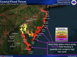
In addition to heavy snow and epic snowfall accumulations in excess of 2 feet in areas, the coast will be battered by major coastal flooding and beach erosion. One to two feet of inundation above ground level is possible in low-lying areas near shorelines and tidal waterways. With moderate coastal flooding, widespread roadway flooding occurs in coastal and bayside communities and along tidal waterways. Here, many roads become impassable and some damage to vulnerable structures may begin to occur. With major flooding, flooding may become severe enough to cause more significant structural damage and some locations may become isolated by the flood waters. Moderate flooding is expected along the entire New Jersey shore and much of the Delaware coast; major flooding is possible from Lewes, Delaware up to Barnegat Light, New Jersey. The worst of the flooding is expected during the Monday afternoon high tide period.
Strong, potentially damaging winds are expected at the coast and even locations far inland. The National Weather Service is predicting wind gusts of 50-60 mph at the Jersey Shore, 40-50 mph around Philadelphia, and 30-40 mph around Reading and Allentown in Pennsylvania. These severe winds will expand north up the coast, with damaging gusts likely across much of Long Island and southeastern New England.
In off-shore waters, winds could reach or exceed hurricane strength, prompting the National Weather Service to issue a Hurricane Force Wind Warning there. For the area of the west central North Atlantic continental shelf and slope waters beyond 20 nm to 250 nm offshore, including south of Georges Bank from 1000 fm to 250 nm offshore, the Hurricane Force Wind Warning is in effect. Here, sustained winds of 55-70 kts are expected, which reach Category 1 hurricane level strength on the Saffir-Simpson hurricane wind scale. Seas will be lethal with seas building 15-30 feet or more. Mariners are urged to avoid the region until the winter storm passes.

By the time the storm exits later Monday, a large populated region should be under 1-2 feet of snow, with portions of eastern New Jersey, Long Island, and southeastern New England potentially getting 2-3 feet or more of snow. The National Weather Service has issued their own updated snowfall forecast map, significantly increasing expected snow amounts over New Jersey in the process; their forecast is better aligned with the original Weatherboy.com forecast map.

