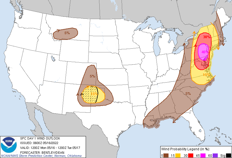
A bullseye of bad weather will exist in portions of the northeast today as severe thunderstorms fire up, bringing damaging wind threats, heavy downpours, and the risk of isolated tornadoes to portions of New Jersey, New York, Pennsylvania, Maryland, Delaware, and Virginia. The National Weather Service’s Storm Prediction Center (SPC) says there’s an enhanced risk of severe thunderstorms here today in their latest Convective Outlook.
According to the SPC, scattered to numerous severe storms are expected today from central New York and western New England south into the Carolinas. Damaging winds, hail, and a few tornadoes will be possible through about dinnertime tonight.
Responsible for today’s severe weather outbreak is a mid-level trough that is moving from the Great Lakes region to the Mid Atlantic today. A potent 55 to 60 knot mid-level jet will round the base of this trough and overspread portions of the Mid-Atlantic during the afternoon and early evening hours as the trough becomes negatively tilted. A surface low will develop along the frontal boundary and deepen through the day as it lifts northeast from western Pennsylvania into central New York.
Storms are beginning to ignite over Ohio. Storm intensity will increase by the late morning hours today as the boundary layer warms. The greatest instability is expected across eastern New York, and east of the Appalachian crests across the Mid-Atlantic where low 60s dewpoints are already in place this morning and are expected to increase further by early afternoon as the surface low deepens.
While the line of storms will likely be fractured across western Pennsylvania and western New York during the morning, the National Weather Service expects it to congeal into a squall line by mid-day as storms reach this reservoir of greater instability. In addition, lower tropospheric flow is forecast to strengthen gradually through the day which should also aid in storm organization.
Much of the forecast area remains under an Enhanced Risk for severe weather later on Monday. Here is a simulated radar animation showing the possible timing of the storms across the area. Damaging winds, hail, and even an isolated tornado is possible. #PAWX #NJWX #MDWX #DEWX pic.twitter.com/kQF5rRm5UM
— NWS Mount Holly (@NWS_MountHolly) May 16, 2022
The SPC warns that strong instability and moderate lower tropospheric flow combined
with the strong forcing should support widespread damaging winds along the squall line expected to form. Moderately strong ascent atop an uncapped warm sector will likely be sufficient for some warm sector storm development ahead of the squall line. The SPC says that moderate effective shear would support supercell storms with primary threats of large hail and damaging winds.
The greatest threat of damaging winds will be over eastern Pennsylvania, western New Jersey, and central Maryland. Here, strong straight-line winds could knock down trees limbs, trees, and/or wires, also taking away objects not secure such as trampolines, garbage cans, political signs, and childrens toys. Efforts should be made as soon as possible to secure any outdoor objects in the high risk area before the storms arrive.
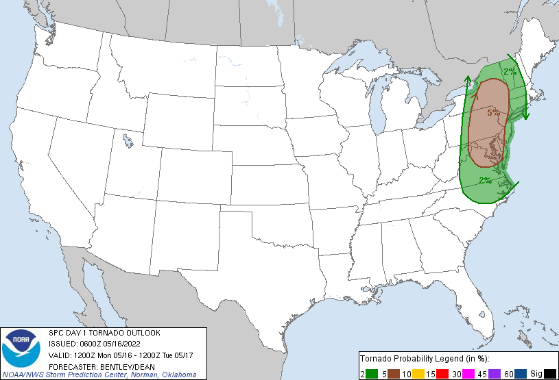
In addition to wind and hail threats, there’s also the risk of isolated tornadoes. The greatest risk of tornadoes in the U.S. today is over portions of New Jersey, Pennsylvania, Delaware, Maryland, Virginia, and New York. Nearby cities of New York, Philadelphia, Baltimore, Washington, DC, and even Burlington have an elevated tornado risk today. While not everyone will see a tornado in these areas, people that live in them should be aware of the risk and know what to do should a Tornado Warning be issued for their community.
The wild weather should turn tame shortly after dinner time this evening, with more stable conditions arriving later tonight.
