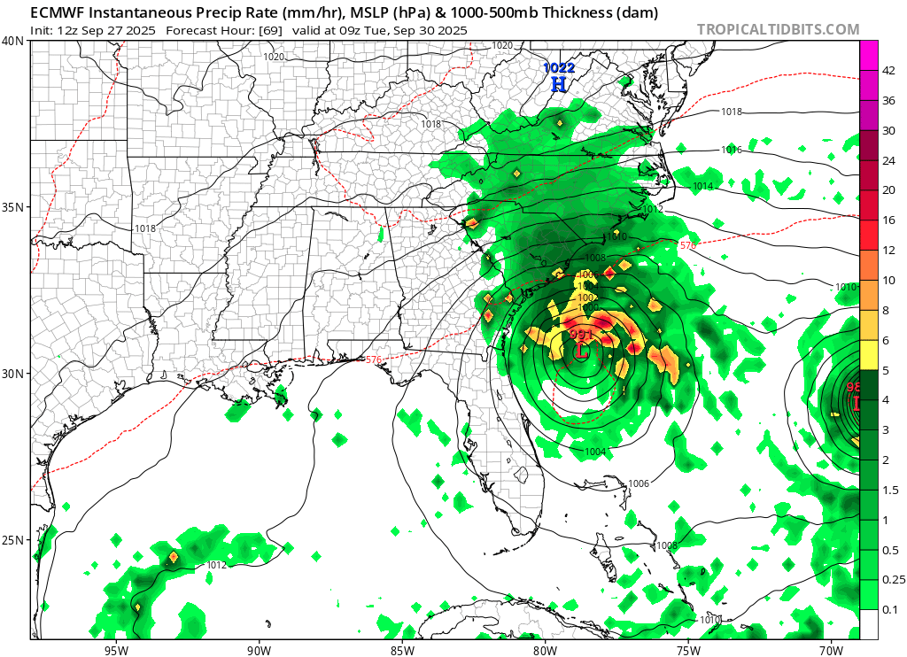
A complicated weather pattern is setting up over the western Atlantic, with the rapid intensification of Hurricane Humberto to a category 5 storm on the Saffir-Simpson hurricane wind scale, and the development of Tropical Depression #9 which the National Hurricane Center expects to upgrade to Tropical Storm Imelda tonight. The close proximity of these storms will help influence the other and it isn’t completely clear how the future storm tracks will unfold with the U.S. East Coast. While the storm track for what’ll be Imelda is far from certain, there is a high probability that there will be significant, possibly catastrophic flooding across portions of North and South Carolina.
In the latest update from the National Hurricane Center (NHC), Hurricane Humberto was located about 350 miles north-northeast of the Northern Leeward Islands and about 685 miles south-southeast of Bermuda. With minimum central pressure down to 925 mb or 27.32″ and maximum sustained wings to 160 mph, Humberto is now tied with Erin as the strongest hurricane of the season and basin.
Humberto is moving toward the west-northwest near 10 mph (17 km/h). According to the NHC, a turn toward the northwest is anticipated on Sunday. Humberto is forecast to then turn northward and move west of Bermuda by Tuesday evening. Maximum sustained winds have increased to near 160 mph and the NHC says additional strengthening is likely; they officially forecast maximum sustained winds to increase to 165 mph tonight. Hurricane-force winds extend outward up to 25 miles from the center and tropical-storm-force winds extend outward up to 125 miles.
Humberto and Imelda will be doing an interesting dance in the coming days. Last night it looked like Humberto may pull Imelda away from the coast, but the latest European model suggests a strike on the East Coast may be inevitable after all. pic.twitter.com/VOBJuzgqlW
— the Weatherboy (@theWeatherboy) September 27, 2025
Swells generated by Humberto will affect portions of the northern Leeward Islands, the Virgin Islands, Puerto Rico, and Bermuda beginning tonight and continuing through next week. Swells from Humberto will also affect the U.S. East Coast beginning Monday. These swells are likely to cause life-threatening surf and rip current conditions.
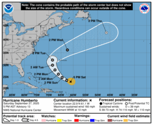
While swells will impact the U.S. East Coast from Humberto in the coming days, the storm itself won’t. The National Hurricane Center officially forecasts it curving out to sea between the U.S. and Bermuda.
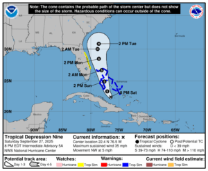
However, Humberto’s strength will help influence the second system taking shape this evening near the Bahamas. For now, this second system is known as Tropical Depression #9 but the NHC believes it will strengthen into a tropical storm by Sunday morning. When the tropical depression becomes a tropical storm, it will be named Imelda. And even though it isn’t technically a tropical storm yet, Tropical Storm Warnings are already in effect.
Based on the latest report from the NHC, this newest storm is located about 210 miles northwest of the eastern tip of Cuba and about 95 miles south-southwest of the Central Bahamas. With maximum sustained winds of 35 mph, the storm is moving to the northwest at 5 mph. Central pressure is down to 1005 mb or 29.68″.
For now, a Tropical Storm Warning is in effect for the Central Bahamas, including Cat Island, the Exumas, Long Island, Rum Cay, and San Salvador, portions of the northwestern Bahamas, including Eleuthera, New Providence, the Abacos, Berry Islands, Andros island, and Grand Bahama Island. A Tropical Storm Warning means that tropical storm conditions are expected somewhere within the warning area, within 36 hours.
A Tropical Storm Watch is also in effect for the east coast of Florida from the Palm Beach/Martin County Line to the Flagler/Volusia County Line. A Tropical Storm Watch means that tropical storm conditions are possible within the watch area, generally within 48 hours.
“Interests elsewhere in the Bahamas and along the southeast coast of the United States from Florida to North Carolina should monitor the
progress of this system,” cautions the NHC. “Additional watches or warnings could be required tonight or on Sunday.”
While the depression is moving slowly toward the northwest near 5 mph now, the NHC says a north-northwestward motion is expected to begin tonight and continue through Monday. On the forecast track, the center of the system is expected to move across the central and northwestern Bahamas on Sunday and Sunday night and approach the southeast U.S. coast early next week. Strengthening is expected during the next few days, and the system is forecast to become a tropical storm tonight or early Sunday and a hurricane by late Monday or Tuesday.
This storm is expected to produce heavy rain wherever it goes. An additional rainfall of 4-8″ is expected across eastern Cuba and the Bahamas. Across Hispaniola, Jamaica, and portions of central and southern Cuba, an additional 1-3″ of rain is expected. This rainfall will likely produce flash and urban flooding. Mudslides are also possible in areas of higher terrain across eastern Cuba.
By early next week, moisture from this system is expected to bring a threat of heavy rainfall from the east coast of Florida northward into the eastern Carolinas. Rainfall amounts of 3-6″ are possible, with localized totals of 10″ across portions of the coastal Carolinas. This rainfall could result in flash, urban, and river flooding.
The NHC also shares caution with regards to rainfall amounts: “Changes in the forecast track could result in adjustments to these rainfall totals.”
Depending on Humberto’s future track and intensity, it may tug at Imelda and help take it out to sea. Or it may keep Imelda stalled in the coastal waters for a considerable amount of time. After being stalled there, it may make landfall into the Mid Atlantic or head out to sea. There is at least 24-48 hours of data that needs to be sorted through to understand where this newest storm will go and how strong it’ll be when it gets there.
Elsewhere in the Atlantic, the tropics are quiet. The NHC expects no other tropical cyclones to develop over the next 7 days throughout the basin, giving them the opportunity to focus all their attention on Humberto …and the system likely to become Hurricane Imelda.
