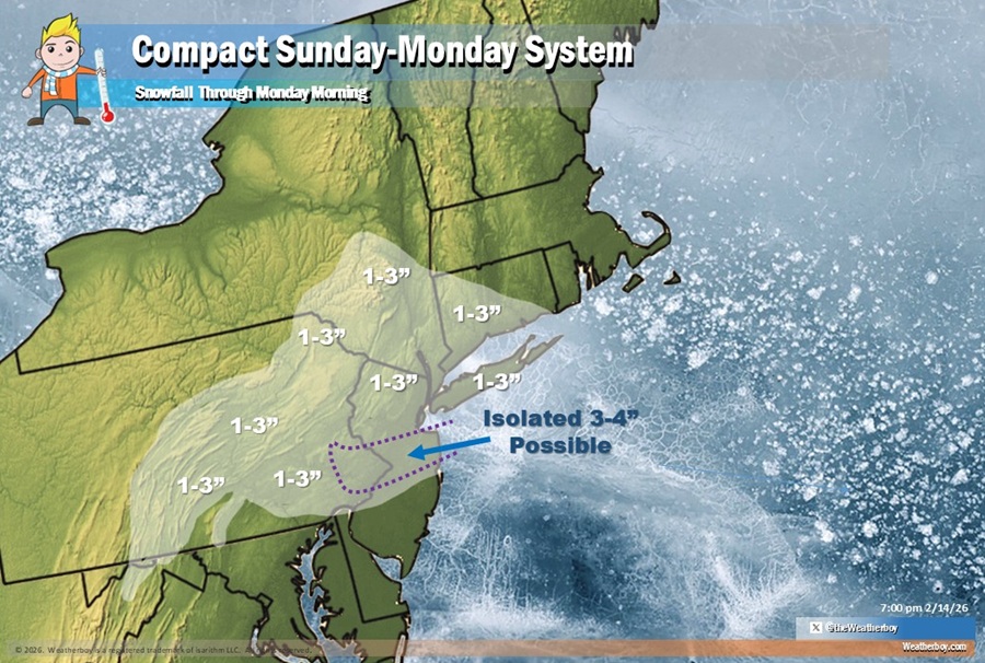
A compact storm will bring some snow to portions of Pennsylvania, New Jersey, and New York later Sunday into Monday. Snowfall amounts will generally be a light 1-2″ but there could be some isolated pockets of 3-4″ amounts, especially near I-195 in New Jersey.
Low pressure currently over the Southern Plains will track east along the Gulf Coast states tonight through Sunday. A warm front will develop out ahead of this low, and on this warm front, overrunning precipitation will push into parts of the Mid Atlantic, specifically the Delmarva, extreme southern New Jersey, and the Delaware Valley late Sunday afternoon. Temperatures will be warm enough for precipitation to fall as plain rain at the start.
On Sunday night, low pressure will track into the Southeastern U.S. and then move north into the Mid-Atlantic. It appears the storm track will take the system off of the North Carolina coast near Cape Hatteras late Sunday night and track it east-north-east out to sea on Monday.
Late Sunday night towards Monday morning, rain falling over southern Pennsylvania and New Jersey will change to snow. With cold air in place north of there, all precipitation should fall as snow. A widespread 1-2″ of snow is expected across eastern Pennsylvania, the northern half of New Jersey, southeastern New York including New York City and Long Island, and southwestern Connecticut.
It is possible just enough moisture and just enough cold air will mingle over portions of east-central Pennsylvania and central New Jersey to create isolated pockets of 3-4″ of snow. While possible, this type of heavier snow would be an outlier and would not be the rule with this system.
No advisories have been issued yet, but the National Weather Service in Mount Holly, New Jersey says a Winter Weather Advisory may be needed for portions of New Jersey Sunday night and Monday morning should these light snow amounts verify.
The compact storm system will exit the coast Monday helping set the stage for a dramatic warm-up for the Mid Atlantic. High pressure will builds into the Eastern Seaboard on Monday, then will establish itself offshore Tuesday through Wednesday. In this type of configuration, a return flow will sets up at the surface while a zonal flow sets up aloft. This allows for warm air advection to develop, and temperatures will finally push to above normal levels.
Although relatively warm for this time of the year, it will also remain cloudy. The temperatures should allow for some of the abundant snowpack to start to melt, but it may not melt as much as it could due to the cloudy skies.
