• Skip to primary navigation
  • Skip to main content
  • Skip to primary sidebar

Weatherboy

Weatherboy Weather News, Maps, RADAR, Satellite, and Forecasts.

  • Local
  • Earth Science News
  • RADAR
  • Current Warnings
  • Satellite
  • Current Maps
  • Forecast Maps
  • Video

Critical (Level 3 of 3) Fire Weather Conditions Return to U.S.

by Weatherboy Team Meteorologist - March 18, 2025

Critical fire weather conditions are moving across the country as very dry and very windy conditions persist.

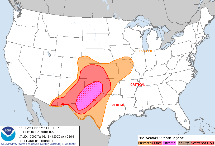
According to the National Weather Service, a level 3 of 3 “Critical” fire weather condition has returned to a large part of the U.S., with Red Flag Warnings now up for almost 300,000 square miles. The area most vulnerable to the fire weather conditions are over the Southern Plains.

A strengthening low pressure system will spread heavy snow across the Central Plains beginning tonight and then pivot through the Upper Midwest and western Great Lakes through Thursday morning. Snowfall rates up to 2 inches per hour are likely which will combine with wind gusts over 50 mph to produce blizzard conditions. The greatest risk for blizzard conditions will be from northern Kansas through southern Minnesota. The combination of heavy falling snow and strong winds will create snow-covered roads and near zero visibility at times.

But the same storm system responsible for blizzard-like conditions there will help produce very dry and windy  conditions on the southern periphery of the winter storm which will promote potential for fire weather in the Southern Plains.

Because of this threat, the National Weather Service’s  Storm Prediction Center issued a Critical Risk of Fires over portions of central, southern and far western Texas over the next couple of days.

Fire Weather Risk through early Wednesday; these threats will spread east over the coming days. Image: NWS SPC


A Red Flag Warning means that critical fire weather conditions are either occurring now or will shortly. A combination of strong winds, low relative humidity, and warm temperatures can contribute to extreme fire behavior in the Red Flag Warning zones. The combination of gusty winds and low humidity will create critical fire weather conditions. The National Weather Service strongly discourages any outdoor burning until the fire weather threat passes.

Primary Sidebar

Sponsored Ad

Search

Latest News

  • White Christmas December 2025?
  • Final Supermoon of 2025 Arrives
  • Geomagnetic Storm WARNING Issued for Earth; G3-STRONG Conditions Expected
  • Morning Shaking in Cooter Reminds of NMSZ Danger of Big Earthquakes Near Missouri
  • Two Earthquakes Strike New York Minutes Apart
  • Winter Storm to Dump A Foot or More of Snow in Northeast
  • Weak Earthquakes Rattle North Carolina and Tennessee Today
  • FAA Declares Emergency Order; Grounds Jets From Multiple Airlines due to Geomagnetic Storm Threat
About | Careers | Contact | Contests
Terms | Privacy | Ad Choices
Weatherboy is a (R) Registered Trademark of isarithm LLC, All Rights Reserved.
All content herein is Copyright by Isarithm LLC 1997-2022

Insert/edit link

Enter the destination URL

Or link to existing content

    No search term specified. Showing recent items. Search or use up and down arrow keys to select an item.