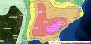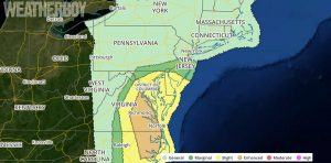
A dangerous severe weather outbreak is likely across portions of the southeast US and Mid Atlantic states over the next 36 hours.
An outbreak of severe thunderstorms is expected from portions of the Southeast States to the Ohio Valley region and eastward to the Mid-Atlantic. Significant tornadoes will be possible, especially from parts of central and southern Georgia into South Carolina, and also from parts of eastern Alabama into south-central Kentucky. In addition, very large hail, and damaging wind gusts are expected.
Ongoing semi-discrete supercells and supercell clusters are developing northeastward from parts of the central/eastern Gulf Coast into southern Georgia. This activity resides well ahead of a shortwave trough across the South-Central States and is evolving within a broad, moistening open warm sector. Due to current observation data, there is increasing confidence that long-track supercells will be likely. Furthermore, with maturing midlevel mesocyclones already evident, and a variety of key meteorological ingredients coming together, confidence has increased in higher coverage of tornado potential — including significant tornado potential — across the now-upgraded High Risk area. This activity will spread across the High Risk area into the evening hours, as vertical wind profiles further strengthen with the approaching midlevel trough. Outflow from ongoing convection from north Georgia to western South Carolina serves as a northern bound to the greatest severe potential.

Furthermore, confidence has increased that substantial severe risk including tornado potential will develop through parts of the Mid-Atlantic region into the overnight hours amid strong low-level and deep shear, and a moistening boundary layer. As a result, severe probabilities have been increased across parts of the Mid-Atlantic.
Also, severe storms are expected to spread across parts of the Gulf Coast vicinity into the evening/overnight hours — affecting parts of north and central Florida with tornado potential.
Farther to the west, a somewhat separate area of severe storm development will be likely from parts of the Ohio Valley region to the Tennessee Valley and vicinity in association with the primary midlevel vorticity maximum and related low-level baroclinic zone this afternoon. Ingredients coming togethere there will will support organized, rotating updrafts from Illinois into Ohio. All severe hazards — including significant hail and tornadoes — will be possible from this afternoon into the evening.
Tomorrow, the worst severe weather activity will be concentrated over eastern Virginia and North Carolina, with severe weather expected as far north as New Jersey.
People in a Slight, Enhanced, Moderate, or High threat area, as defined by the Storm Prediction Center’s Convective Outlooks, should make sure they are completely prepared for the arrival of severe weather. Knowing where a safe place is in your home, work, or school and knowing what to do before a Tornado Warning or Severe Thunderstorm Warning is issued for your county is key to safety. Make sure you have a way to receive storm warnings from the National Weather Service; battery-operated NOAA Weather Radios provide the best access to such alerts.