While still recovering from flooding rains and damaging winds from the last storm, it looks like people in the eastern United States need to prepare for two more new storms; it appears another rain/wind storm is in the cards for this weekend followed by the potential of a snowstorm that could bring plowable snow to the I-95 corridor between Washington DC and New York City.
In general, the overall weather pattern will continue to be extremely active across the continental U.S. through the end of the week and into Saturday morning. An amplifying upper level trough over the Southwest U.S. early on Thursday will then eject over the southern Plains and induce rapid surface cyclogenesis, leading to another high impact storm system that will once again hammer much of the eastern half of the country, with a similar track to the event earlier this week.
The surface low will quickly deepen from Arkansas to Michigan, dropping to near 975 mb by Saturday morning. There will be a tight pressure gradient around this low, particularly to the northwest where a major winter storm with blizzard conditions is expected from eastern Nebraska to central Michigan with widespread 6-12″ snowfall totals within this corridor of the Midwest, with potentially over a foot of snow across northern Lower Michigan.
Another round of severe weather is also appearing more likely across the Deep South and into the Southeast U.S. through late Friday evening in the warm sector of the low, where favorable parameters of kinematics and instability will exist. This also includes the threat of tornadoes along with the main threat of damaging wind gusts.
In terms of heavy rainfall potential, it appears the overall rainfall from this event will be generally less than what occurred earlier this week for most areas across the East Coast due to the faster progression of the moisture plume and lighter rainfall rates. However, there may be some areas of 1-2″ rainfall totals across portions of the northern Mid-Atlantic and into the Northeast that could cause some instances of flooding across already super-saturated grounds.
A much colder arctic airmass will continue settling south and east in the wake of this storm across the Plains, Midwest, and into the Ohio Valley. Temperatures will be brutal compared to the relatively mild conditions that have been experienced for much of the winter season up to this point in time. Afternoon high temperatures will likely fail to reach zero degrees across much of Montana and into North Dakota on Friday, and highs only in the 0s and 10s across the Central Plains and into Iowa and Minnesota. This arctic airmass will be lengthy in duration and persist well beyond the end of the week.
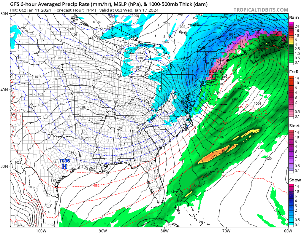
As this cold air mass settles to the south and east, the stage could be set for a new storm system to form during the early to middle part of next week. With cold air in place, precipitation that blossoms around it could fall as snow rather than rain in areas of the I-95 corridor that haven’t seen significant snow in a long time.
