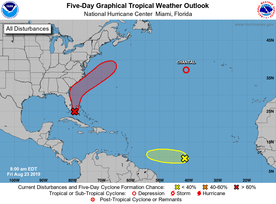
After a long lull in the tropical Atlantic, it appears a tropical cyclone is likely to form along the U.S. East Coast in the coming days. While that threat materializes, eyes are also looking at the central Atlantic for signs of potential development there. While these two systems could grow over time, one is fading away: Chantal continues to dissipate over the cold waters of the North Atlantic.
According to the National Hurricane Center (NHC) in Miami, Florida, surface and radar data indicate that a weak area of low pressure is located just east of the upper Florida Keys and the southeastern coast of the Florida peninsula. This system is producing a large area of disorganized cloudiness and showers that extends primarily northeast of the center over the northwestern Bahamas and the adjacent Atlantic Ocean. According to the NHC, the low is forecast to move near or over the Florida peninsula through tonight, which should limit development during that time. Environmental conditions appear conducive for development once the system moves northeastward back over the Atlantic waters on Saturday. A tropical depression is likely to form this weekend or early next week while the low moves from near the coast of east-central Florida to offshore of the southeastern United States coast. Regardless of development, locally heavy rains are possible over the northwestern Bahamas and southern and central Florida through the weekend. Seas will also be rough along much of the U.S. East Coast, making for dangerous surf for beach-goers and bumpy conditions for those on cruise ships and pleasure craft. The NHC believes there’s a 40% chance that a tropical cyclone will form here over the next 48 hours but increases those odds to 70% over the next 5 days.
In the central Atlantic, showers and thunderstorms have increased since yesterday in association with a tropical wave located about 1,400 miles east-southeast of the Windward Islands. According to the NHC, additional slow development of this system is possible during the next few days as it moves generally westward at about 15 mph. For now, odds of development are low; the NHC says there’s only a 10% chance of tropical cyclone formation over the next 48 hours and only 20% chance over the next 5 days.
Meanwhile, Tropical Depression Chantal is spinning about over the colder waters of the North Atlantic. The NHC expects this system to dissipate over the open waters with no direct impacts to any landmass expected.
