A potent thunderstorm impacted Maryland last night; the National Weather Service today confirmed the overnight destruction was the result of an EF-2 tornado.
The National Weather Service (NWS) in Mount Holly, NJ surveyed the storm damage area around Stevensville in Queen Anne’s County Maryland today. According to a preliminary report issued by the NWS, a waterspout developed over the Chesapeake Bay between Annapolis and Stevensville, Maryland just south of the Chesapeake Bay Bridge as estimated by radar velocity from the Baltimore-Washington Airport Terminal Doppler Weather Radar. The waterspout moved ashore at 1:29 AM in the Bay City Area of Kent Island and then traveled northeast toward Stevensville, Maryland where it lifted at 133 AM after being on the ground for about 2 miles.
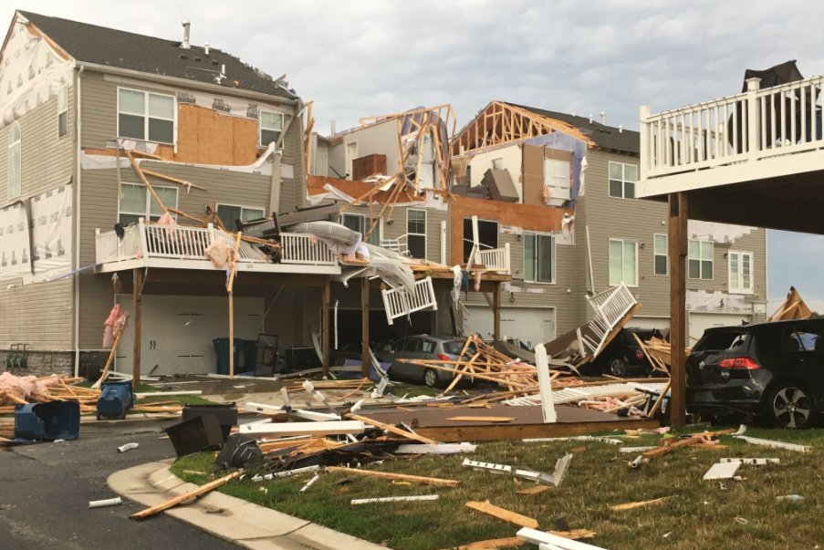
The National Weather Service says maximum winds were estimated at 125 mph which makes this an EF-2 tornado. Several wood framed townhomes had the upper floors entirely lifted off along with the roof; several other homes had either roofs lifted off and tossed or received other damage. One business was destroyed. There was one injury to a person who was punctured by debris. In addition, there were trees and power lines down and some gas leaks were reported along with a structure fire to a home.
The scale that rates this tornado an EF-2 is known as the Enhanced Fujita Scale. It classifies tornadoes based on their wind speeds. EF-0 tornadoes have wind speeds 65 to 85 mph; 1 has winds 86 to 110mph; 2 has winds 111-135mph; 3 has winds 136-165mph; 4 has winds 166-200mph; 5 has winds in excess of 200mph.
It has been an active last few weeks in the Mid Atlantic for tornadoes and waterspouts. Earlier yesterday, a waterspout formed near Fortescue, New Jersey and was captured on camera. Weeks before, two tornadoes and a microburst touched down in central New Jersey.
