
The National Hurricane Center says Tropical Storm Erin is gaining strength and expects it to become a hurricane …and then a Major Hurricane… by this weekend. The storm is currently located over the open waters of the central North Atlantic.
“Locally heavy rainfall, high surf and rip currents, and tropical-storm force winds could occur in portions of the northern Leeward Islands, the Virgin Islands, and Puerto Rico this weekend as
he core of Erin passes north of those islands,” warns the National Hurricane Center (NHC) in their latest update. “Interests in these areas should continue to monitor the progress of Erin.”
According to the NHC, it is still too soon to say with certainty where the storm will head in the extended range. “While there is still uncertainty in what impacts might occur in portions of the Bahamas, the east coast of the United States, and Bermuda next week, the risk of dangerous surf and rip currents across the western Atlantic basin next week is increasing,” the NHC said in their latest update on Erin.
“As we approach the climatological peak of the hurricane season, this is an opportune time to ensure your preparedness plans are in place,” the NHC recommends.
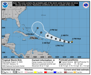
According to the last NHC update, Erin was located about 1,200 miles east of the Northern Leeward Islands. Maximum sustained winds have increased to 50 mph while the minimum central pressure has dropped to 1001 mb or 29.56″.
Erin is moving toward the west near 17 mph and the NHC says that this general motion is expected to continue into Thursday, with a west-northwestward motion beginning Thursday night and continuing into the weekend. On the official NHC forecast track, the center of Erin is likely to move near or just north of the northern Leeward Islands over the weekend. As it heads west, gradual strengthening is forecast during the next couple of days, and Erin is expected to become a hurricane by Friday and a Major Hurricane with winds of at least 115 mph by Sunday afternoon.
Swells generated by Erin will begin affecting portions of the northern Leeward Islands, the Virgin Islands and Puerto Rico by this weekend. These swells are likely to cause life-threatening surf and rip current conditions.
While many computer forecast models suggest that Erin will now pass between the U.S. East Coast and Bermuda, it is still too early to say with certainty where it will go.
