
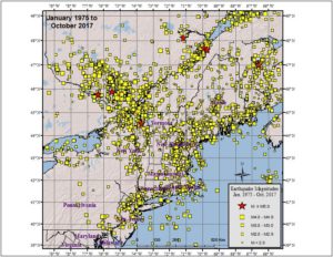
According to USGS, a pair of earthquakes rattled Connecticut and Massachusetts last evening, adding to a growing list of earthquakes reported across the eastern United States in recent days and weeks. USGS says there have been 217 earthquakes in the eastern United States over the last 30 days, including recent earthquakes in Ohio, Tennessee, North Carolina, New Hampshire, Georgia, Kentucky, Louisiana, Arkansas, Alabama, and Maine. While this is a high number for the eastern United States, it isn’t for the western United States, which recorded 4,725 over the same period, according to USGS.
The first earthquake hit southern Connecticut at 5:36 pm. According to USGS, this weak magnitude 1.9 event struck from a depth of 5 km near East Haddom, which is located half way between Hartford and New London and Norwich and New Haven.
The second earthquake hit southern Massachussetts due east of the Connecticut one, striking at 9:11 pm near Acushnet which is just east of New Bedford. This quake struck from a depth of 9.5 km and was a slightly weaker magnitude 1.8 event.
According to USGS, earthquakes with a magnitude of 2.0 or less are rarely felt or heard by people, but once they exceed 2.0 , more and more people can feel them. While damage is possible with magnitude 3.0 events or greater, significant damage and casualties usually don’t occur until the magnitude of a seismic event rises to a 5.5 or greater rated event.
The Connecticut earthquake wasn’t located far from an area infamous for its “Moodus Noises.” The area has had a history of seismic activity and due to the geology there, even minor earthquakes create loud booms, rumbles, and/or mysterious sounds.
Reports of these “Moodus Noises” stretch back centuries; Native Americans called the area Machimoodus, which means “Place of Bad Noises.” They attributed the noises to evil spirits and Gods. Years later, English colonists later associated the noises with witches or the Devil.
Connecticut is no stranger to earthquakes with most weak or mild but damaging earthquakes do occur from time to time in the state. The strongest earthquake to strike on record struck on May 16, 1791. Estimated to be a magnitude 4.4 to 5.0 event, it knocked down chimneys and stone walls, threw open doors in homes, and also created a fissure in the ground several yards long. That seismic event was actually 2 earthquakes in quick succession and was followed by dozens of lighter aftershocks.
People elsewhere in New England, and in its geological extension southward through Long Island, have felt small earthquakes and suffered damage from infrequent larger ones since colonial times. Moderately damaging earthquakes strike somewhere in the region every few decades, and smaller earthquakes are felt roughly twice a year. The Boston area was damaged three times within 28 years in the middle 1700’s, and New York City was damaged in 1737 and 1884. The largest known New England earthquakes occurred in 1638 (magnitude 6.5) in Vermont or New Hampshire, and in 1755 (magnitude 5.8) offshore from Cape Ann northeast of Boston. The Cape Ann earthquake caused severe damage to the Boston waterfront. The most recent New England earthquake to cause moderate damage occurred in 1940 (magnitude 5.6) in central New Hampshire.
According to the Northeast States Emergency Consortium, there were 320 earthquakes between 1638 and 2016; earthquakes that struck in 1638 and 1940 produced damaging results.
