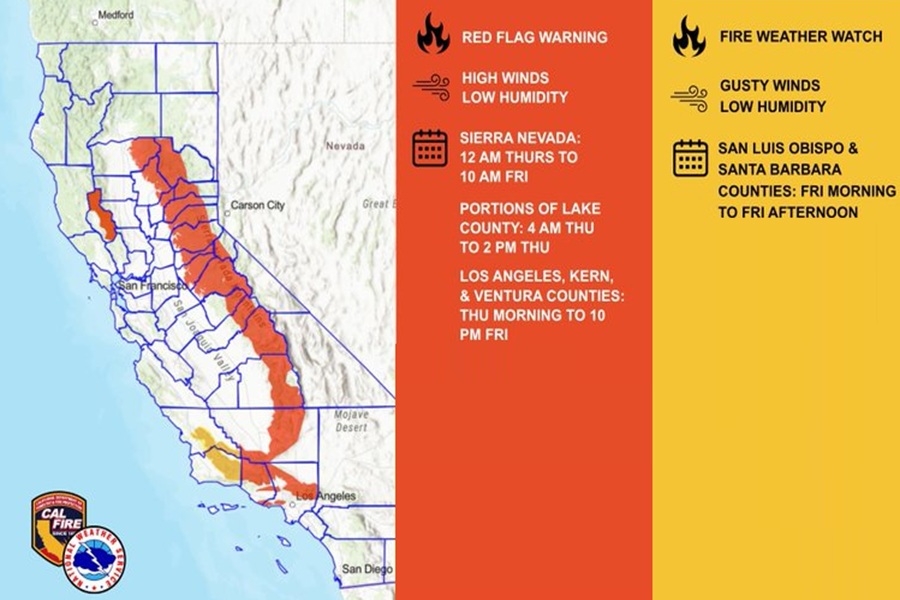
The National Weather Service is warning that a serious fire weather situation is setting up for portions of California including the Los Angeles metro area over the next few days.
“The first Santa Ana event for the season is going to be a strong one,” warned the Los Angeles / Oxnard, California office of the National Weather Service in their latest Forecast Discussion.
A Santa Ana wind is a strong, extremely dry, and warm-to-hot offshore wind that originates in the cool, high-pressure air masses of the Great Basin around Nevada and Utah and sweeps downslope toward the Southern California coast and northern Baja California. As cool desert air is pushed out of the Great Basin, it descends from high mountain elevations down towards sea level. Through a dynamic meteorological process known as adiabatic compressional warming, as the air sinks, atmospheric pressure compresses it which causes the temperature to rise rapidly. Generally, this temperature rise is about 30 degrees per mile of descent. Because the air warms as it descends, its relative humidity also exponentially drops, sometimes below 10% or 5%. This helps not only remove moisture from the atmosphere, but from parched late-summer or early autumn vegetation too. With high wind gusts and bone-dry conditions, any spark could trigger a conflagration: downed power lines, faulty electrical equipment, hot vehicle exhaust, improperly disposed cigarettes, camp fires, outdoor grills, or arson are all potential sparks for such a fire. And due to the extreme wind speeds in Santa Ana conditions, it makes it dangerous or impossible for firefighting crews to fight the fire, especially when using air-based assets such as flame-retardant dropping planes or helicopters with water buckets.
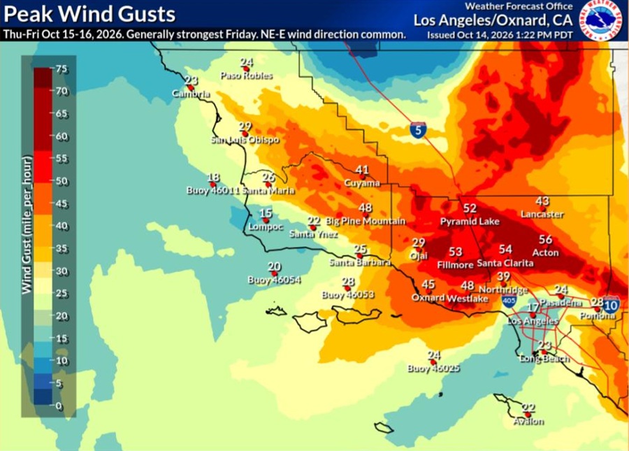
The National Weather Service says that forecast models and ensemble gradients are all pointing to a strong event with with very strong northeast winds at 850 mb and surface gradients around 8-9mb from the east.
“There have been some gusty north to northeast winds to 30-40mph this morning in the San
Gabriel Mountains and across the western San Fernando Valley,” says the National Weather Service, adding, “But the primary days will be Thursday through Saturday, with Friday being the strongest.”
During that peak period wind gusts across the Los Angeles and Ventura mountains are expected to reach as high as 70 mph while the Los Angeles and Ventura Valleys and Ventura coastal areas peak at around 55 mph. While typical Santa Anas do not include the Los Angeles Metro
area, Antelope Valley, or the Central Coast, some of the latest model forecasts indicate at least some 15-30 mph gusts in those areas too.
Offshore flow will steadily increase each day through Thursday or Friday, then weaken over the weekend. During the Thursday and Friday peak, northeast winds of 20 to 40 mph with gusts to 40 to 60 mph will be common over the wind prone areas of Los Angeles and Ventura Counties, with localized gusts of 60 to 70 mph in the mountains. Winds will be unusually widespread on Friday, when much of Santa Barbara and San Luis Obispo will experience a few hours windy conditions, especially the interior mountains where winds of 15 to 25 mph and gusts of 30 to 40 mph are expected. Meanwhile, the air will rapidly warm and dry. High temperatures between 85 and 95 will be common by Friday, warmest near the coast where the risk for heat illness is high. Minimum humidity levels will generally lower into the 5 to 15 percent range by Friday, with poor overnight recoveries starting Thursday.
“All of this will add up to a high risk for large fires and rapid fire growth over most of the area, especially over Los Angeles and Ventura Counties as well as interior San Luis Obispo and Santa Barbara Counties where Red Flag Warnings and Fire Weather Watches are in place,” cautions the National Weather Service. “While some areas received rain earlier this week, the dry day today will largely remove any benefiting effects on the fuels.
