A Flood Watch covers all of Rhode Island and parts of southeast Massachusetts from 4 a.m. EST Friday, Nov. 6, through Saturday morning as heavy rain associated with a sprawling storm system spreads across southern New England, the National Weather Service in Boston/Norton said.
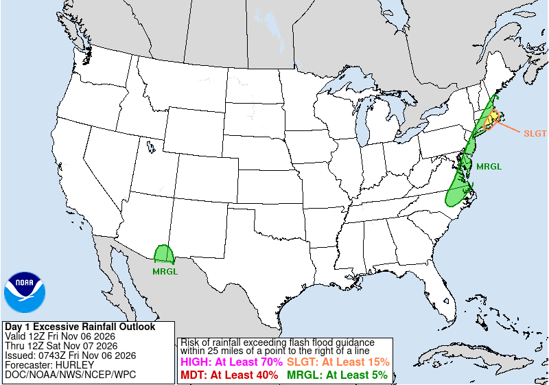
Forecasters said periods of rain will be heavy at times across Rhode Island and southeast Massachusetts, including Cape Cod and the Islands, with the greatest concern for street flooding and poor-drainage flooding where autumn leaves clog storm drains. The Weather Prediction Center placed parts of southeastern New England in a Slight Risk of excessive rainfall for the 12Z Friday through 12Z Saturday period.
“Widespread rain arrives today and continues tonight before tapering off early Saturday,” the Boston/Norton Area Forecast Discussion said early Friday. “Rain will be heavy at times across RI and southeast MA, including Cape Cod and the Islands.”

The Flood Watch, continued in an NWS product issued at 12:54 a.m. EST Friday, includes Barnstable, Dukes, Plymouth and Bristol counties in Massachusetts and all of Rhode Island — Block Island and Bristol, Kent, Newport, Providence and Washington counties — taking in cities such as Providence, Warwick, Fall River, New Bedford, Brockton, Taunton and Plymouth. A watch means flooding is possible. A flood warning would mean flooding is occurring or imminent in a more specific area.
NWS Boston/Norton forecasters said they have high confidence in widespread rainfall of 1 to 3 inches, with lower probabilities of isolated 4 to 5 inches where the heaviest bands linger. The official Flood Watch text said periods of heavy rain may produce an area of 2 to 4 inches across Rhode Island and southeast Massachusetts, with a low risk — less than 30% — of isolated 5 to 6 inches. CBS Boston said southeastern Massachusetts, including southern Plymouth and Bristol counties as well as Cape Cod and the Islands, faces the highest risk for several inches, with the Boston area on the edge of the heaviest rainfall.
The main threat is urban and poor-drainage flooding rather than widespread river flooding, the Area Forecast Discussion said. Forecasters noted that 4 or more inches would generally be needed for minor flooding on small rivers and streams in Rhode Island and southeast Massachusetts. Leaf-clogged drains will exacerbate street flooding in typical flood-prone communities such as New Bedford, Fall River, Providence and Cranston, the discussion said.
“Storm drains and ditches may become clogged with debris,” the Flood Watch product said. “You should monitor later forecasts and be alert for possible Flood Warnings. Those living in areas prone to flooding should be prepared to take action should flooding develop.”
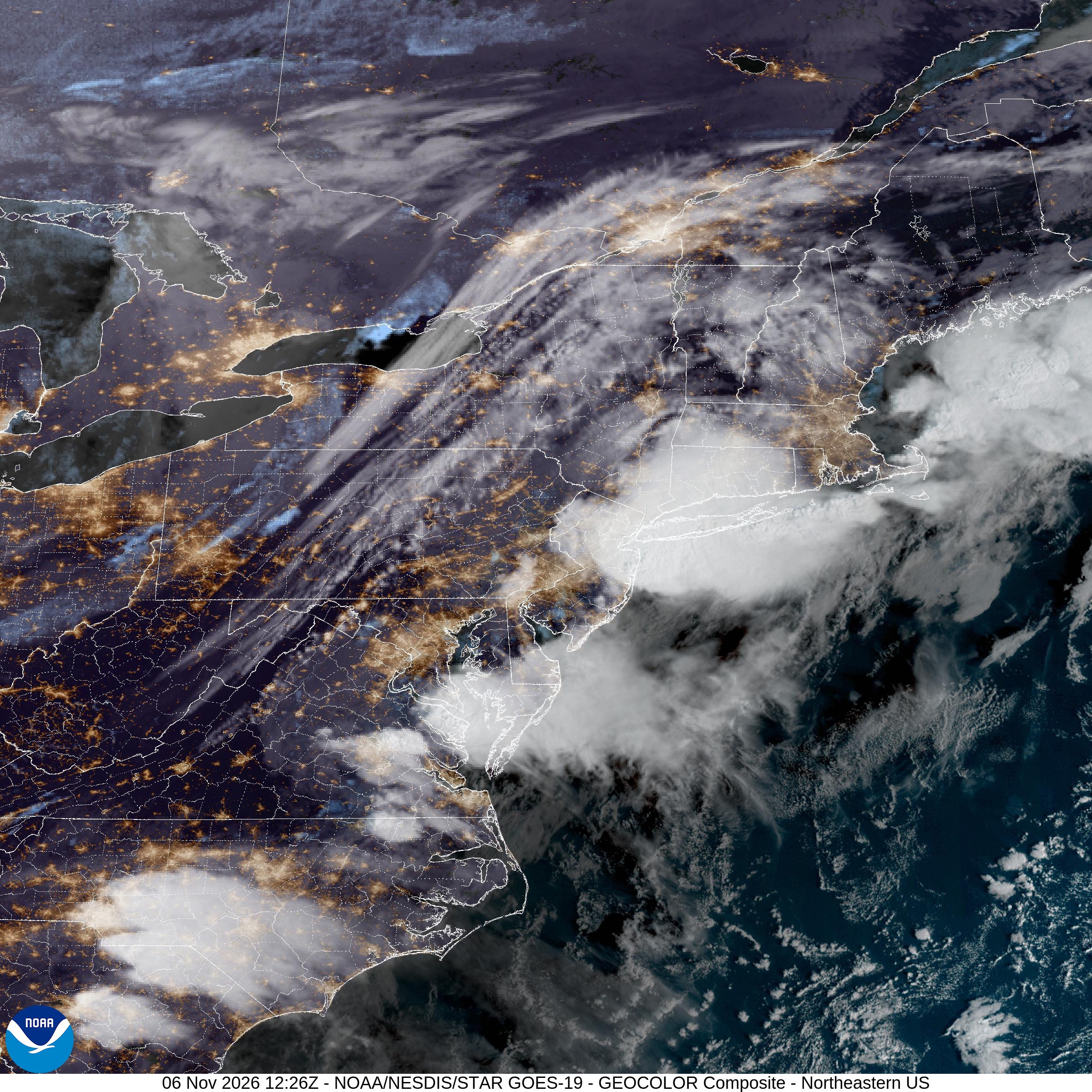
The rain is tied to a massive cross-country storm that has already affected more than 35 states, Fox Weather reported. After weeks of dry weather, measurable rain began reaching parts of the Northeast on Thursday, ending dry streaks in cities including New York and Philadelphia, though amounts there were still tiny — 0.03 inch in New York City and 0.01 inch in Philadelphia on Thursday, Fox Weather said. Boston and Providence had gone more than two weeks without rain and were still waiting for their streaks to end as of Thursday evening, Fox Weather reported. CBS Boston said Friday it had been nearly three weeks since Boston recorded measurable rainfall, the longest streak in two years.
A secondary upper-level disturbance was expected to bring another round of unsettled weather Friday, Fox Weather said, with a particularly wet morning commute along the Interstate 95 corridor and periods of rain and a few thunderstorms possible in unstable air. NWS Boston noted some lightning overnight south of Long Island and a few flashes south of Cape Ann, and said a few thunderstorms remain possible Friday, especially off the south coast of Rhode Island and southeast Massachusetts, though storms are not expected to be widespread.
Guidance early Friday had nudged the axis of heaviest rain slightly farther north because of a somewhat slower cold front, the Area Forecast Discussion said, but confidence remained highest for the heavier totals across Rhode Island and southeast Massachusetts. Elsewhere across Connecticut into northern Massachusetts, less rain is expected and the flood threat is limited, forecasters said.
The Weather Prediction Center’s Day 1 Excessive Rainfall Outlook, issued at 2:43 a.m. EST Friday and valid from 12Z Friday to 12Z Saturday, maintained a Slight Risk across parts of southeastern New England. WPC said edits based on 00Z guidance pulled the outlook area west about 20 to 40 miles while expanding it a bit farther southwest and north, covering eastern and southeastern Connecticut and far eastern Long Island along with much of the Boston metro area. Fox Weather described a Level 2 of 4 flash flood threat from eastern Long Island into portions of southern New England, including Providence and Boston.
WPC said precipitable water values approaching 1.75 inches are close to three standard deviations above normal for early November, while integrated vapor transport exceeds 750 kg/m/s through late afternoon in major model guidance. Models continued to show an axis of 2.5 to more than 5 inches of quantitative precipitation within the Slight Risk area, WPC said, with mixed-layer CAPE of 500 to 1,000 J/kg aiding potentially excessive short-term rainfall rates.
CBS Boston and NBC Boston both emphasized preparation for localized street flooding. Residents were urged to clear leaves from storm drains and check sump pumps in flood-prone basements. NBC Boston said rain would remain widespread through the day, with the heaviest downpours expected in the afternoon and continuing into Friday night, and that fallen leaves clogging storm drains could make matters worse. Streams and creeks will be rising and low spots will start to pick up water even if major river flooding is not the primary concern, NBC Boston said.
Temperatures Friday were forecast to remain unusually mild for early November. NWS Boston said overnight lows Friday morning were expected to be higher than normal daytime highs, with several climate sites challenging calendar-day record high minimums. Record warm minimums to watch included 65 degrees at Boston, 64 at Hartford/Bradley and Providence, and 62 at Worcester, the climate section of the Area Forecast Discussion said.
Rainfall chances were expected to diminish Saturday morning with a lull, then increase again Saturday afternoon into Saturday night as the colder core of an upper-level low moves overhead, the Area Forecast Discussion said. A few showers Saturday may produce heavy rainfall and small hail as cold air aloft steepens lapse rates. Cooler and drier conditions are expected next week, with highs falling back into the 50s and overnight lows in the 30s and 40s after the weekend system clears.
For drivers along the I-95 corridor from Rhode Island into southeast Massachusetts, the practical message Friday is slowing down, avoiding flooded underpasses and never driving through water of unknown depth. The National Weather Service flood safety guidance stressed that most flood deaths occur in vehicles. School transportation, Friday evening plans and coastal travel to Cape Cod and the Islands could face the greatest disruption where the heaviest rain sets up.
Us Air Net, summarizing NWS and WPC products early Friday, said the watch covers Providence, Cranston, Fall River, New Bedford, Cape Cod and the Islands among other communities, and that the exact stripe of heaviest rain could still shift. Commuters and residents in poor-drainage neighborhoods should treat the Flood Watch as a signal to prepare — clear drains, move cars from chronic flood spots and monitor for upgrades to warnings — rather than assume every town in the highlighted area will flood.
The combination of anomalous November moisture, a slow-moving frontal zone and leaf-choked urban drainage makes localized flooding a credible risk through Saturday morning across Rhode Island and southeast Massachusetts even after a prolonged dry spell.
