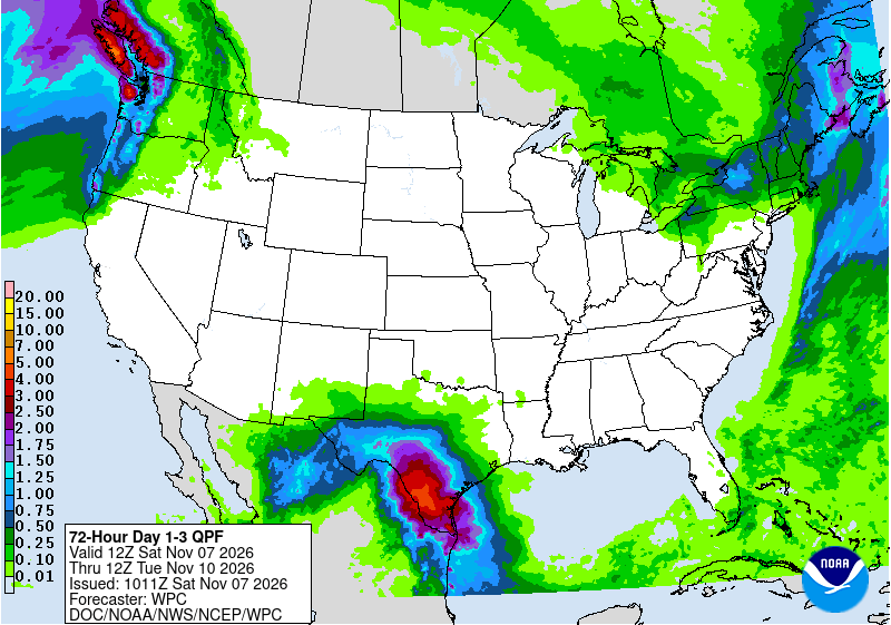
A slow-moving storm system pulling moisture from the Gulf is expected to soak South Texas from Saturday through Monday, prompting a flood watch for much of the region and warnings that some areas could see more than 5 inches of rain.
The National Weather Service office in Corpus Christi issued the watch Friday night for an area stretching from Laredo and Cotulla to the Coastal Bend, including Corpus Christi, Kingsville, Alice, Beeville, Goliad, Rockport, Port Aransas and the barrier islands. The watch runs from noon CST Saturday through Monday morning.
“Widespread forecast rainfall amounts of 2-4 inches will be common across South Texas with high end amounts approaching 5 inches,” the weather service said in the watch. “Isolated amounts exceeding 5 inches remains a possibility, especially in the vicinity of training and slow moving storms.”
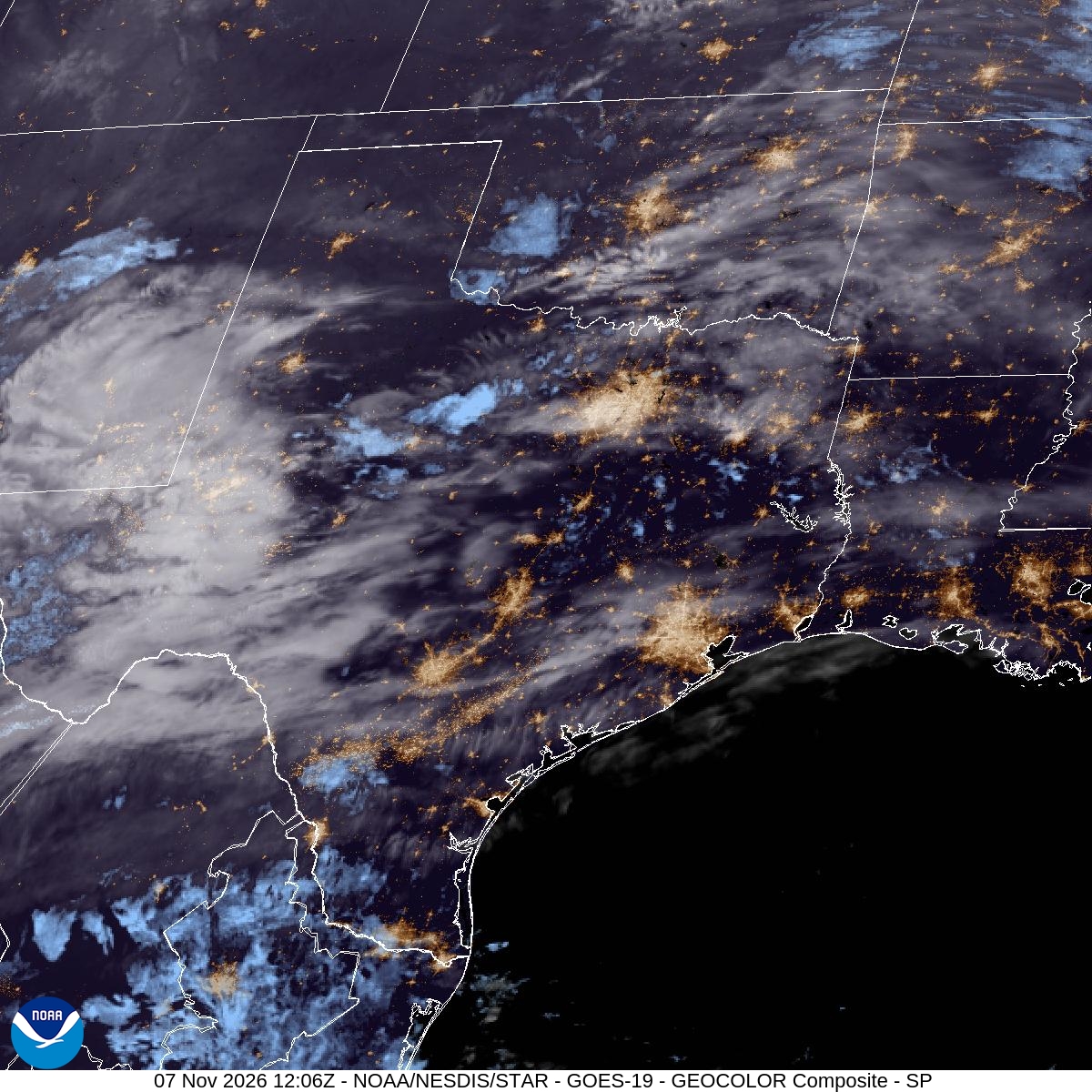
As of early Saturday, the heaviest rain had not yet reached South Texas. Radar showed rain and embedded storms over far West Texas, while the Corpus Christi office expected showers and thunderstorms to reach Laredo and Cotulla by Saturday evening and expand overnight.
How the Setup Came Together
Forecasters said the rain is being driven by an upper-level system that moved southeast across Arizona and is expected to cut off from the main jet stream over northern Mexico by Sunday. The NOAA Weather Prediction Center said the system was already producing moderate to locally heavy rain from southern New Mexico into West Texas early Saturday.
As the low settles over Mexico, easterly winds will push Gulf moisture inland and up against the Sierra Madre Oriental mountains in northeastern Mexico, the Corpus Christi office said. That lift is expected to start the rain along the Rio Grande and the Edwards Plateau Saturday afternoon and evening, followed by more widespread showers and storms across the Brush Country early Sunday as a low-level jet and an approaching front add fuel.
The amount of moisture in the atmosphere is unusually high for November. The Corpus Christi office said precipitable water values, a measure of how much water the air column holds, are forecast to climb to near 2 inches, approaching two standard deviations above normal. Forecasters said that would support efficient rainfall and heavy downpours through Sunday, spreading toward the coast.
Where the Heaviest Rain Could Fall
The Weather Prediction Center placed parts of South, Central and West Texas under a marginal risk, level 1 of 4, of excessive rainfall Saturday, then raised the risk to slight, level 2 of 4, for Sunday into Monday morning across south-central and South Texas.
In its discussion, the center said forecast models showed a broad area of 2 to 3 inches of rain from the central Rio Grande Valley into south-central Texas, with a core over the Hill Country and southeast toward the King Ranch area. Several models showed local totals of 4 to 6 inches, and one run of the European model showed more than 8 inches east of Laredo, which the center described as “the upper threshold of the potential.”
The center said the greatest odds of heavy rain were between Laredo and Corpus Christi, especially in Webb, Duval and Zapata counties.
The Corpus Christi office said some guidance had shown totals as high as 9 inches, “though this is on the extreme end.” Forecasters said a key uncertainty is how far south a surface front moves. If the front reaches Deep South Texas, the heaviest rain could stay south of the Benavides area, the office said.
Forecasters said soils should absorb much of the rain, and flash flood guidance, the amount of rain needed to cause flash flooding, is relatively high at 3 to 5 inches in six hours. But they warned that storms training over the same areas, especially in Laredo and along the Coastal Bend, could quickly cause flooding in urban areas and places with poor drainage.
WeatherNation meteorologists said rainfall rates of 1 to 2 inches per hour or more are possible Sunday and that severe storms cannot be ruled out because of wind shear around the low.

San Antonio, Austin Expect Steadier Rain
Farther north, the weather service office serving Austin and San Antonio described the rain as mostly beneficial. Forecasters there expect widespread totals of 1 to 3 inches, with isolated pockets of up to 5 inches where repeated rounds occur, and said nearly everyone should get at least a half inch to an inch.
“These totals may seem like a lot but we arent expecting any heavy torrential downpours but rather some good old fashioned steady cool rain that will occur over a period of several days rather than all at once,” the office wrote in its Saturday morning discussion.
Still, the office said embedded thunderstorms could produce rates of 1 to 2 inches per hour, and those cells would be the main concern for isolated flooding if they move over urban corridors or repeatedly cross the same areas. The office said Sunday is expected to be “a very dreary, damp and downright miserable rainy day,” with highs in the low to mid-60s and some areas struggling to get out of the mid-50s on Monday.
Rain chances climb sharply over the weekend. The Corpus Christi office put the chance of rain in Laredo and Cotulla at 90% on Sunday, while the Austin/San Antonio office forecast a 100% chance Sunday for Del Rio, San Antonio, Austin and Hondo. In Corpus Christi, the chance rises to 70% Sunday, and the office said temperatures across the region Sunday will struggle to climb much above the morning lows.
In the Rio Grande Valley, the Brownsville office forecast 1.5 to 3 inches of rain Sunday into Sunday night across most of Deep South Texas, with isolated pockets of 4 to 5 inches possible.
Coastal Flooding and Rip Currents
The storm also brings concerns along the coast. The Corpus Christi office said the approaching new moon and 20- to 25-knot east-northeast winds could push water levels to 2 to 2.5 feet along the Middle Texas Coast during high tides from Sunday through at least midweek.
That could make driving on beaches tricky and leave some areas near bays and estuaries impassable at times, forecasters said. A high rip current risk is in effect from Sunday morning through late Sunday night, and small craft advisory conditions are expected over Gulf waters from Sunday morning through Monday morning.
What to Expect Next Week
The rain is expected to wind down during the day Monday, the Corpus Christi office said, with low rain chances of 10% to 30% lingering through Wednesday, mainly near the coast. Drier air is forecast to arrive late in the week, with highs slightly below normal and lows in the 50s by next weekend.
The weather service urged residents in flood-prone areas to monitor forecasts and be ready to act if flood warnings are issued. Meteorologists there advise people to keep important documents in places that will stay dry, clear gutters and drains and check the status of their flood insurance.
