An unusual storm system set-up, basically a late-autumn nor’easter in the middle of July, will dump very heavy, flooding rains on portions of the Mid Atlantic over the next 48 hours. For many, this rain storm will feature the heaviest rainfall seen to date in what’s become a very wet year.
As seen in winter storms, computer forecast models that meteorologists use to aid in their forecasting have waffled on their solutions, some suggesting a widespread, prolonged heavy precipitation event, others suggesting a more concentrated event with very heavy rain. It appears a more concentrated, more brief storm system is what’ll become of this unusual nor’easter.
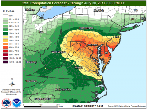
While some of the details have changed, one remains constant: exceptionally heavy rain is expected over parts of southern New Jersey, all of Delaware, most of Maryland, and portions of southern Pennsylvania and northern Virginia. Here, rain in excess of 4″ may fall. Beyond heavy downpours, some thunderstorms will also fire-up near the Mason-Dixon line; these storms will help tap into an abundant moisture supply. With storms likely to train over the same area over and over, some places may see well over 4″ and an isolated 6″ wouldn’t be shocking.
Because heavy rain fell in this same general area days ago, and as a result, the ground and river systems haven’t had the opportunity to dry and recover, there is an increased threat and likelihood of flooding conditions. Flash flooding is a very likely, especially in the area where the heaviest rain is expected to fall near the Mason-Dixon line. Remember: never walk or drive through flood waters; heed the warning: turn around, don’t drown!

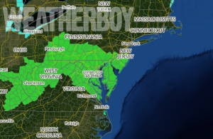
Because the storm system is more concentrated than spread out, the chance for flooding north of I-195 in New Jersey and I-76 / The Pennsylvania Turnpike is substantially reduced. Because of that reduced threat, the National Weather Service has trimmed back the area now under a Flash Flood Watch. The Flash Flood Watch remains up for Maryland, Delaware, northern Virginia, West Virginia, and southern New Jersey and Pennsylvania.
Rainfall will be heaviest from Friday afternoon to Saturday morning, with the greatest threat of thunderstorm activity later today. Many thunderstorms will be strong and some will even reach severe limits, possibly containing large hail and/or damaging wind gusts. In this atmospheric set-up, a tornado outbreak is not expected. While lightning can kill, the largest threat from these rain showers and thunderstorms will be the rain itself: flash flooding will pop-up creating deadly hazards where it does so.
With a more progressive weather pattern setting up, this storm system should exit the coast earlier than what was expected yesterday. We now forecast most of this storm to be wrapped up by Saturday afternoon, with fair, dry conditions returning for the balance of the weekend.