Rivers that swamped the Four Corners region for the second time in two weeks began dropping Wednesday, but evacuation orders remained in force along the Animas, La Plata and San Juan rivers, and officials in New Mexico and Colorado said the work of digging out would take weeks or longer.
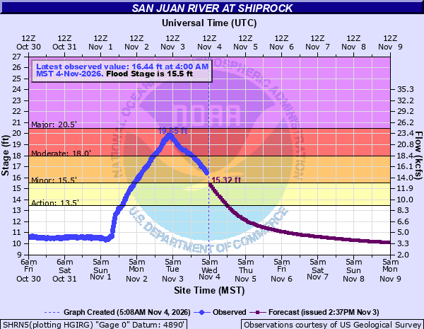
The National Weather Service said the San Juan River at Shiprock on the Navajo Nation crested at 19.8 feet at 3 a.m. Tuesday. By 4 a.m. Wednesday, the river had fallen to 15.44 feet, according to the National Oceanic and Atmospheric Administration’s river gauge. Upstream in Farmington, the Animas River crested at 13.46 feet just after midnight Tuesday, which meteorologist Todd Shoemake described as moderate flooding, the Tri-City Record reported. The San Juan River at Farmington reached 12.18 feet Monday afternoon, a level Shoemake called “major flooding” for that area.
“We believe that the crest has passed on all rivers, but it will take 24-48 hours for floodwaters to recede,” the San Juan County Office of Emergency Management said Tuesday morning. “Do not reenter evacuated areas. Hazards exist in the water and with utilities.”
A Second Round on Soaked Ground
The latest flooding came on the heels of what the Santa Fe New Mexican described as a historic surge of river flooding the week before that damaged at least 1,500 homes across San Juan County. Officials had estimated 2,000 to 3,000 people were displaced by that first round, and many had not returned home when new evacuation orders went out Monday, the newspaper reported.
More than 20 trillion gallons of rain fell on the Four Corners states and Nevada over the past two weeks, The Associated Press reported, citing former NOAA chief scientist Ryan Maue. The rain fell on ground already saturated by an especially wet fall. One person died in floodwaters in the region, and police suspect a second death was weather-related, the AP reported.
On Monday, San Juan County ordered evacuations for all locations within a half-mile of the Animas, La Plata and San Juan rivers, along the San Juan River from Hogback to Four Corners and from the New Mexico-Colorado line to the confluence of the Animas and San Juan rivers in Farmington, KKOB radio reported. In Farmington, the county called for an immediate evacuation from Cedar Street to Murray Drive and from Broadway Avenue to Auburn Avenue after the Animas River breached its banks.
The Tri-City Record reported that more than 74,000 county residents had been evacuated and that 27,400 residential and commercial structures had been damaged as of Tuesday morning. Devin Neeley, a spokesperson for San Juan County, told the AP that evacuation orders affected at least 20,000 residents and that the county would likely soon lift them and turn to recovery.
“Now it’s a waiting game for the waters to recede,” Neeley said.
Farmington spokeswoman Gina Intoppa said evacuation orders along river corridors would be “strictly enforced until river levels recede below the designated action stage, anticipated Wednesday into Thursday,” the Tri-City Record reported. She said the National Guard remained in the area and that joint damage assessment teams were set to begin evaluating property as the water receded.
Roads, Power and Water
Flooding cut off roads across the county. As of Tuesday afternoon, Piñon Hills Boulevard was closed from 30th Street to La Plata Highway, the County Road 5500 bridge was closed and Miller Bridge was closed until further notice pending a structural review, according to the Tri-City Record. Highway 539 near Navajo Lake State Park was closed from mile marker 0 to mile marker 5 because of severe flood damage, the county said in an update posted by Watch Duty.
About 450 Farmington Electric Utility System customers remained on planned safety outages Tuesday, Intoppa said, with five line crews working to restore power where it was safe. Lift stations serving Kirtland and Aztec were offline because of power outages, and Aztec asked residents to conserve water. The county said water from the domestic supply was safe to drink but that private wells may be affected and should be tested.
A Red Cross shelter at McGee Park in Farmington remained open, and a resource center was operating at San Juan College, the county said.
Colorado Towns Dig Out
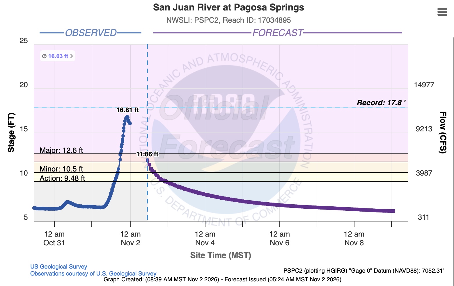
Across the state line, the San Juan River left a mess in Pagosa Springs, a tourist town known for its riverside hot springs. The downtown area remained closed to traffic Tuesday while crews used heavy equipment to clear mud, water and debris, and walkways and bridges collapsed or were heavily damaged, the AP reported.
“This is quite a disaster for everybody, especially in the low-lying areas,” Jack Ellis, a retired schoolteacher surveying damage along the river, told the AP. “We dig in and dig out, and that’s what it’s going to take.”
In Durango, about 60 miles to the west, Willow Bradner said nearly 5 feet of water from an overflowing creek poured into her home at one point and that the house was surrounded by about 2 feet of mud.
“Our basement became a soup bowl,” she said.
Gov. Jared Polis has declared a disaster emergency for 12 southwest Colorado counties: Alamosa, Archuleta, Conejos, Dolores, Hinsdale, La Plata, Mineral, Montezuma, Ouray, Rio Grande, San Juan and San Miguel. Durango declared a local disaster Nov. 2, according to the Colorado Division of Homeland Security and Emergency Management. On Oct. 31, Polis asked President Donald Trump for a major disaster declaration for Archuleta and Rio Grande counties, citing about $27 million in damage eligible for federal public assistance.
“The damage documented so far exceeds what state and local resources can address alone,” Polis said in a statement.
The governor’s office said Colorado mobilized nearly 100 National Guard members with aviation and ground resources and rescued 48 people and 31 animals during the earlier round of flooding. A disaster assistance center in Pagosa Springs was set to open Thursday at the Club Wyndham Resort activities building, according to the state emergency management division.
What’s Next
Forecasters said drier weather should help. Matt DeMaria, a meteorologist with the weather service in Albuquerque, told the Bernalillo Herald that a dry week ahead should help cleanup, though flooding at Shiprock could linger.
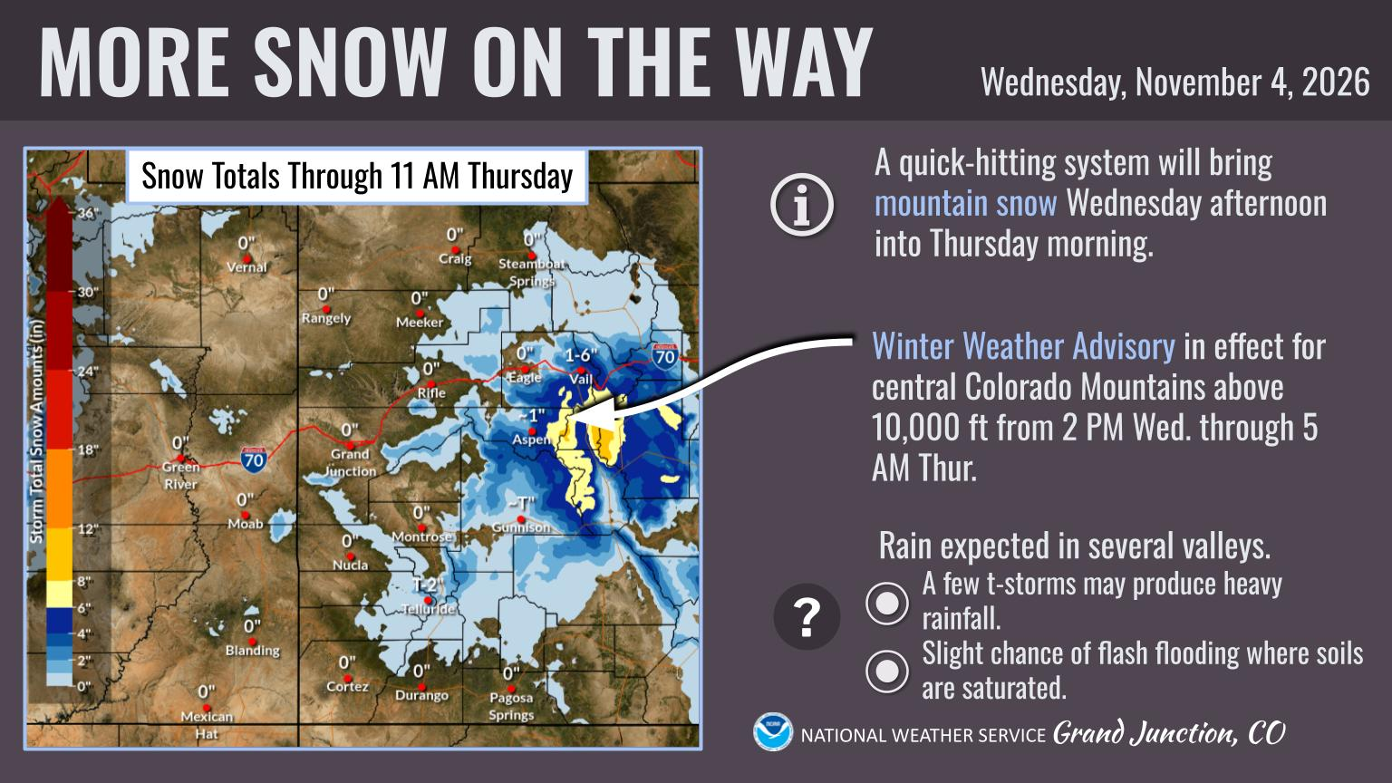
The weather service in Grand Junction said a quick-hitting system would bring mountain snow to central Colorado Wednesday afternoon into Thursday morning, with a winter weather advisory for elevations above 10,000 feet. The office forecast rain in several valleys and said a few thunderstorms could produce heavy rain, with a slight chance of flash flooding where soils are saturated. Its forecast map showed little or no snow for Durango and Pagosa Springs.
San Juan County officials urged residents to document damage and losses for insurance and disaster aid and to call 211 for information on resources, volunteers and donations.
