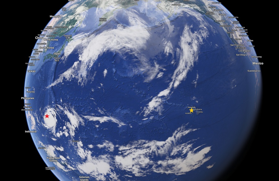
Guam is about to feel the full impacts of the strongest typhoon to strike the island in decades; Super Typhoon Mawar continues its march closer and closer to the island, with impacts and damage already being reported across the U.S. territory home to 170,000 Americans. The storm is being monitored by numerous government agencies including the National Weather Service in Tiyan, Guam and the Joint Typhoon Warning Center based at Pearl Harbor on the island of Oahu in Hawaii. At 3,945 miles away, Hawaii is the closest state to Guam and shares many links.

The office of Hawaii’s Governor Josh Green, M.D., released this statement ahead of Mawar’s landfall: “The office of Governor Josh Green, M.D., is closely monitoring developments with Super Typhoon Mawar, knowing that many of our residents are from Guam or have family ties there. Governor Green reached out to Guam Governor Lou Leon Guerrero and spoke with her personally today to convey that Hawaiʻi is here for Guam. As always, the State of Hawaiʻi is standing by, ready to support our dear island neighbor in any way we can.”
Yesterday, local time, Guam Governor Lou Leon Guerrero placed Guam in Condition of Readiness (COR) 1, which means destructive winds are possible within 12 hours. The Governor’s office urged the community to remain indoors until COR 4 is announced. The Governor ordered that all residents in low lying, flood-prone and coastal areas, especially in the southern villages of Inalåhan, Ipan, Talo’fo’fo, Malesso’, Hågat and Humåtak, to evacuate and seek shelter in private residences or designated government shelters in higher elevation.
The Pentagon said Naval Base Guam sent its ships away from shore while aircraft based at Andersen Air Force Base took shelter in hangars there or were flown off the island. As of press time, the military couldn’t confirm if aircraft was sent to Hawaii or other locations in the Pacific.
The latest RADAR loop shows #SuperTyphoonMawar inching closer and closer to Guam. Powerful winds about to blast the U.S. Territory could knock this RADAR unit off-line. pic.twitter.com/1eJxmamvaD
— the Weatherboy (@theWeatherboy) May 24, 2023
Earlier today, President Joe Biden approved an Emergency Declaration for Guam. The President’s action authorizes FEMA to coordinate all federal disaster relief efforts to alleviate the hardship and suffering caused by the emergency on the local population and to provide appropriate assistance to save lives, to protect property, public health and safety and to lessen or avert the threat of a catastrophe territory wide.
Specifically, FEMA is authorized to identify, mobilize and provide at its discretion, equipment and resources necessary to alleviate the impacts of the emergency. Emergency protective measures, limited to direct federal assistance, under the public assistance program, will be provided at 75% federal funding.
The National Weather Service (NWS) is warning that Mawar is likely to bring widespread damage across Guam from powerful winds, heavy rains, and damaging surf. The NWS said they expect considerable damage to buildings and homes of light material, extensive damage to non-concrete roofs, and non- reinforced concrete walls to be blown down. The NWS said severe damage to well-built wooden and metal structures is possible.
The NWS is painting a picture of what the aftermath could look like: “Large projectiles and debris are possible. Most small and medium sized steel frame signs could be bent over or damaged. Some fuel storage tanks could rupture. Cars and high paneled vehicles could be overturned. Major damage to shrubbery and trees is likely with snapped or uprooted trees and blocked roads. Defoliation of vegetation is likely, perhaps 50-70% defoliation. Electricity and water may be unavailable for days and perhaps weeks after the storm passes. Many trees will be snapped or uprooted. Fallen trees may cut off residential areas for days to weeks.”
The NWS is also warning about the potential for historic storm surge on the island. If Mawar passes over southern Guam or just south of Guam, this would bring a large storm surge into vulnerable coastal areas of Malesso, Inalahan, Ipan and Pago Bay. Storm surge of 6 to 10 feet above the normal high tide is likely. Surge could possibly reach to between 20 and 25 feet above normal high tide if the worst scenario of a southern Guam or just south of Guam eye passage occurs. Considerable coastal impacts are likely with impassable roads due to debris and boulders. “Severe coastal erosion is likely. Large boats could be torn from moorings. Extensive damage is possible,” the NWS says.
Surf is forecast to continues to build along the south and east facing reefs, with dangerous surf of 20 to 30 feet possible into Wednesday. Rough surf may develop along west facing reefs as early as Thursday, with hazardous surf possible Thursday night or Friday.
Epic rain is also expected. The NWS says torrential rain is likely as Mawar passes near or overhead, with hourly rainfall rates at 7″/hour in the eyewall. A slower forward motion may lead to rainfall of 15 to 20 inches with locally higher amounts. The NWS warns, “Landslides are a distinct possibility for central to southern Guam along with overflowing streams and rivers. Locations that do not normally flood may see considerable flooding.”
Tropical cyclones are called hurricanes east of the International Date Line; west of the International Date Line, they are called Typhoons. Hawaii and the U.S. East and Gulf Coast don’t start their hurricane season until June 1. On Thursday, May 25, both the National Hurricane Center in Miami, Florida and the Central Pacific Hurricane Center in Honolulu, Hawaii will release their seasonal outlook for the upcoming season.