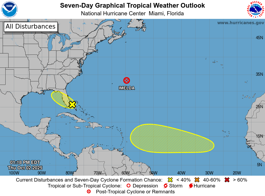
What was once Hurricane Imelda has evolved into a strong, extratropical cyclone and is on its way to the open waters of the Central Atlantic; while the National Hurricane Center (NHC) has concluded issuing advisories on that system, they are tracking two areas of concern that may develop into tropical cyclones.
The first area of concern is in the southwestern Atlantic near Florida. According to the NHC, which continues to track systems despite the ongoing government shutdown, says that an area of low pressure may form along a remnant frontal boundary near the northwestern Bahamas and southern Florida during the next day or two. However, they also say that any additional development is expected to be slow to occur as the system moves northwestward across the Florida Peninsula and into the Gulf of America. For now, the NHC says there’s only a 10% chance that this system develops into a tropical cyclone over the next 7 days.
The second system being monitored is in the far Tropical Atlantic. A tropical wave is expected to move off the coast of Africa over the next day or two. Thereafter, the NHC says that this wave is forecast to interact with another disturbance in the eastern tropical Atlantic, and some slow development of the combined feature is possible as the system moves westward to west-northwestward at 15 to 20 mph. While odds are better that this system will develop rather than the Florida one, odds are pretty low; the NHC says there’s only a 20% chance of tropical cyclone formation here over the next 7 days.
Elsewhere in the Atlantic Hurricane Basin, the NHC says there is no other area of concern.
The Atlantic Hurricane Season runs through to the end of November.
