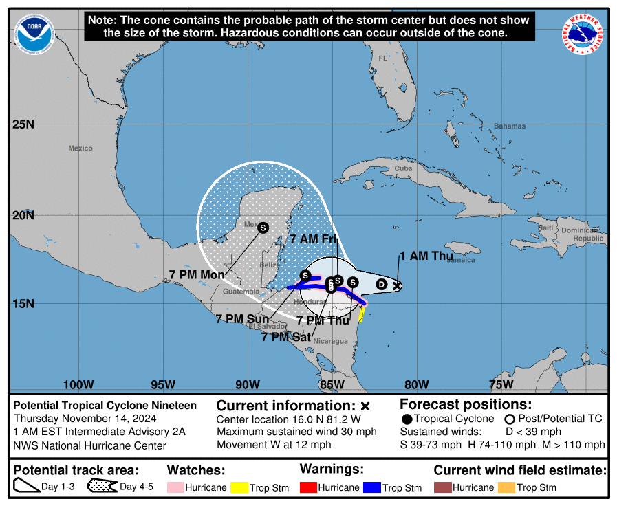
Hurricane Watches have been issued for Potential Tropical Cyclone #19, a new system developing in the northwestern Caribbean that is likely to become Tropical Storm or Hurricane Sara in the coming days.
As of the latest update from the National Hurricane Center this morning, the potential tropical cyclone was located about 145 miles east-northeast of Cabo Gracias a Dios on the Nicaragua / Honduras border and about 315 miles east of Isla Guanaja, Honduras. Maximum sustained winds are only 30 mph for now while the minimum central pressure is down to 1005 mb or 29.68″. The system is moving toward the west near 12 mph and the National Hurricane Center says a westward motion should continue for another day or so, taking the system across the western Caribbean Sea. The disturbance is expected to stall and meander near the north coast of Honduras late Friday and through the weekend. The system is forecast to become a tropical storm later today and continue strengthening, if it remains over water.
With the system expected to become better organized and stronger, a Hurricane Watch is in effect for Punta Castilla to the Honduras/Nicaragua Border and for the Bay Islands of Honduras. A Tropical Storm Warning is in effect for this same area too. A Tropical Storm Watch is in effect for the Honduras/Nicaragua Border to Puerto Cabezas.
A Hurricane Watch means that hurricane conditions are possible within the watch area. A watch is typically issued 48 hours before the anticipated first occurrence of tropical-storm-force winds, conditions that make outside preparations difficult or dangerous.
A Tropical Storm Warning means that tropical storm conditions are expected somewhere within the warning area within 36 hours.
A Tropical Storm Watch means that tropical storm conditions are possible within the watch area, generally within 48 hours.
Through early next week, rainfall amounts of 10-20″ with isolated storm totals around 30″ are expected over northern Honduras. This rainfall will lead to widespread areas of life-threatening and potentially catastrophic flash flooding and mudslides, especially along and near the Sierra La Esperanza. Elsewhere across the rest of Honduras, Belize, El Salvador, eastern Guatemala, and western Nicaragua, the storm is expected to produce 5-10″ of rain with localized totals around 15″ through early next week. This will also result in areas of flash flooding, perhaps significant, along with the potential of mudslides.
It is still too soon to know with certainty what impacts, if any, this system will have on the U.S. Gulf Coast. The more time this new system drifts over Central America and/or heads over mountainous terrain there means chances are lower of major U.S. impacts. However, if the system stays mainly over water with limited interactions with land around the Yucatan Peninsula, this new system could produce dire conditions somewhere along the U.S. Gulf Coast over time.