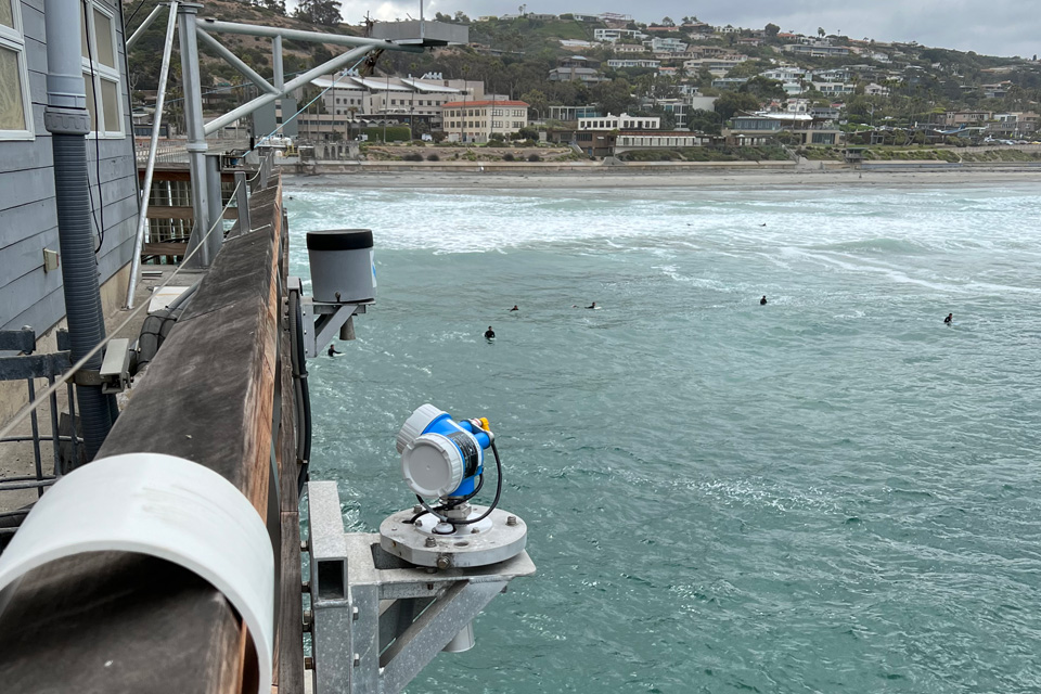
High tides boosted by warm ocean water and a building swell from the west threatened to push seawater into low-lying streets, beach parking lots and harbor walkways along nearly the entire California coast Monday morning, two weeks after record-high water levels flooded parts of Southern California.
National Weather Service offices from Eureka to San Diego posted coastal flood advisories for Monday’s late-morning high tides. Most run through noon Tuesday, and the San Francisco office’s advisories for San Francisco Bay, San Pablo Bay and southern Monterey Bay run through 4 p.m. Friday.
The Los Angeles/Oxnard office said the combination of high tides and high surf would bring “hazardous swimming conditions, dangerous conditions on rock jetties, and a risk for moderate coastal flooding,” with impacts peaking Monday when the surf peaks.
Central Coast and Ventura County at Highest Risk
The Oxnard forecasters said this round would differ from flooding earlier this year. During the coastal flooding of September and early October, the swell came from the south and hit places such as Long Beach and Malibu hardest. This time, the swell is from the west to northwest.
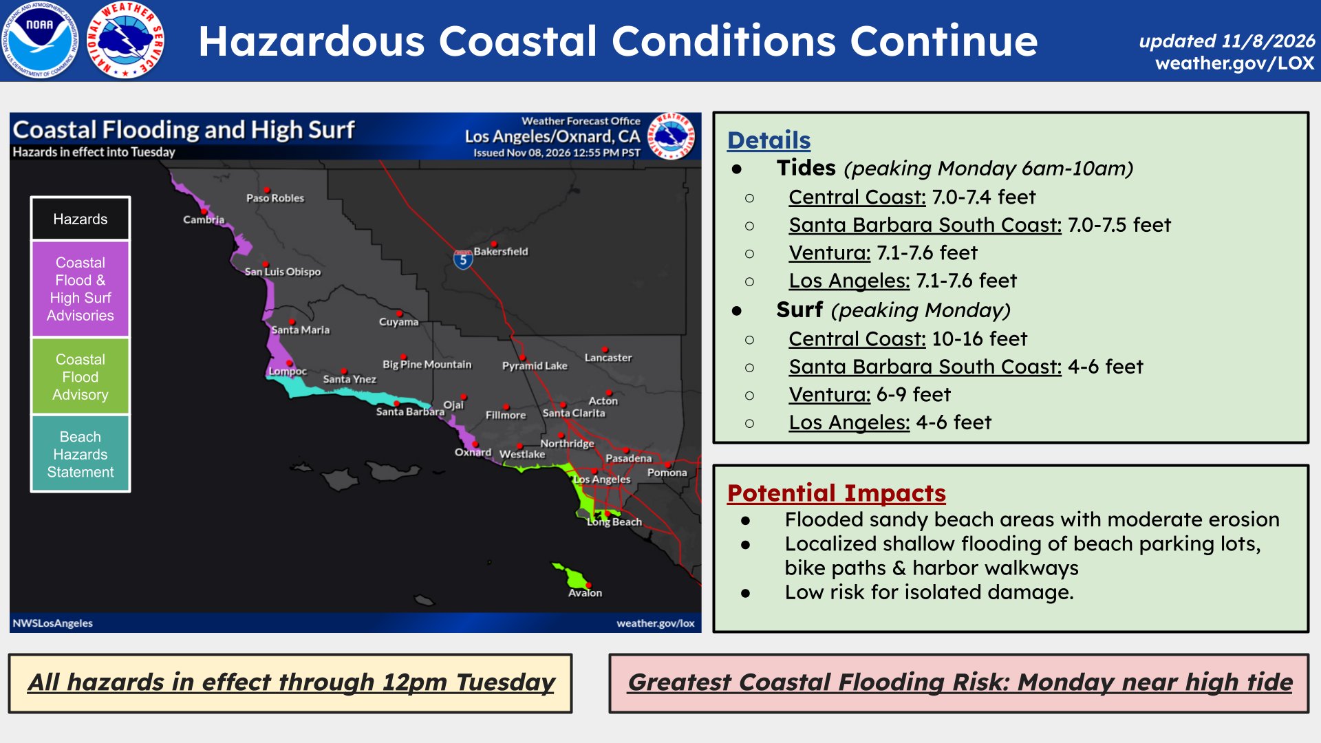
“For west-facing shores however, the risk is much higher than events in the recent past,” the office wrote in its Monday morning discussion. “Areas like Oceano and Cayucos on the Central Coast, and the Ventura County coast, have elevated risks of moderate coastal flooding.”
Breaking waves of 10 to 16 feet were forecast on San Luis Obispo County beaches and Santa Barbara County’s Central Coast beaches, with high tides of 7.1 to 7.4 feet above mean lower low water each morning. On Ventura County beaches, waves of 5 to 7 feet were forecast to peak at 6 to 9 feet Monday, with high tides of 7.2 to 7.6 feet.
The advisories warn of flooded sandy beach areas, moderate beach erosion and shallow flooding of beach parking lots, bike paths and walkways. Forecasters said the damage already done to beaches this year adds to the risk.
“Isolated damage is unlikely but cannot be ruled out especially considering the extent of beach erosion we have already seen – which limits the natural protective buffer between the ocean and coastal infrastructure,” the office wrote.
The Central Coast advisories may need to be extended through the week, forecasters said.
For Los Angeles County beaches, Malibu and Catalina Island, the weather service forecast minor to locally moderate flooding during morning high tides. It said harbor areas and Naples Island in Long Beach should see generally minor impacts because the tides “will not be nearly as high as the record breaking tides from two weeks ago.”
Southern California Tides Run Above Predictions
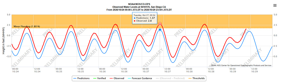
In Orange and San Diego counties, the weather service in San Diego said the highest tides would arrive in the late morning, peaking at 7.2 to 7.4 feet Monday, “which is 1.2 to 1.4 feet above astronomical tide predictions.”
The office expected flooding of parking lots and roads with only isolated road closures. It forecast minor coastal flooding with areas of moderate flooding along west-facing beaches, where surf of 3 to 7 feet was expected.
Ocean temperatures remain unusually warm for November. The weather service’s surf forecast listed water temperatures of 72 to 74 degrees off Los Angeles County beaches and 70 to 73 degrees off Ventura County beaches Monday.
Bay Area and Humboldt Bay
Around San Francisco Bay, the weather service in Monterey said “a combination of high astronomical tides and thermal expansion from warmer than normal water” would cause tidal flooding at shoreline locations along San Francisco, San Pablo and Monterey bays.
The office forecast high tide at the San Francisco gauge at 7.4 feet, 1.6 feet above normal, at 10:35 a.m. Monday, and 7.3 feet at 11:04 a.m. Tuesday, with tides above normal each day through Friday. Up to 1.6 feet of water above ground level is possible in low-lying areas near shorelines and tidal waterways, the advisory said, bringing flooding of low-lying infrastructure, isolated road closures and coastal erosion.
Along the Pacific coast, a beach hazards statement warned of breaking waves of 12 to 16 feet at exposed beaches and up to 18 feet at favored break points, along with sneaker waves and strong rip currents. “Waves can sweep across the shoreline without warning, pulling people into the sea from beaches, jetties, and rocks,” the advisory said.
On the North Coast, the Eureka office warned of minor flooding around Humboldt Bay from 10 a.m. to noon Monday, with high tide at 10:52 a.m. at the North Spit gauge. Water levels inside Humboldt Bay were running 1.2 to 1.3 feet above astronomical tides, and the bay could reach about 8.8 feet or nearly 9 feet if southerly winds pushed water higher, forecasters said. Flooding will likely affect Jackson Ranch Road in the Arcata Bottoms and several roads in King Salmon, the advisory said.
Two Weeks After the Records
Monday’s tides follow a damaging stretch in late October. From Oct. 24 to 30, four California tide gauges set all-time highs, NOAA’s National Ocean Service said: San Diego at 2.80 feet above mean higher high water, Los Angeles at 2.70 feet, and La Jolla and Santa Barbara at 2.65 feet each.
NOAA blamed several factors. A perigean spring tide, when the moon was full and closest to Earth, raised tides. El Nino-driven Kelvin waves can raise sea level by 6 to 12 inches or more for weeks as they move up the West Coast, and an ongoing marine heat wave added thermal expansion, the agency said.
The flooding was severe in places. A tide in Newport Beach reached a record 8.4 feet Oct. 27, and a San Pedro gauge reached a record 8.02 feet the day before, NBC Los Angeles reported, citing the weather service. In Long Beach, eight structures with 13 residences had been red-tagged, the station reported. The Los Angeles Times reported that Pacific Coast Highway was closed at Sunset Beach.
What Comes Next
The Monterey office said Monday’s spring tides come with a new moon, which is lower in the sky this time of year than a full moon. Higher tides are ahead.
“In 2 weeks, the astronomical tides will be about 0.8′ higher than this round, and the total water level could be more than a foot higher if we get SW winds and/or lower pressure,” forecasters wrote. That combination would bring the total water level near the 1% annual exceedance probability, or a 1-in-100-year event, they said. “Something to keep an eye on for the week of Thanksgiving.”
NOAA has predicted above-normal high tides Nov. 22-27 and Dec. 22-26, bringing an increased risk of flooding to the state.
Weather changes are also coming. Forecasters in Oxnard expect a cooling trend starting Thursday and a 30% to 40% chance of rain each day from Saturday through Monday. The Eureka office said stronger storms could bring more widespread rain Friday and Saturday, and the Monterey office said a much larger swell is forecast to arrive next weekend.
The weather service urged people not to drive around barricades or through water of unknown depth and to stay off jetties, piers and rocks. “Never turn your back on the ocean,” the San Francisco Bay Area office said.
