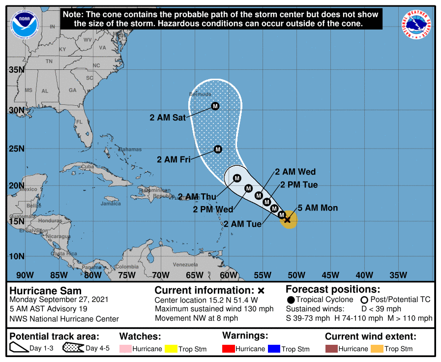
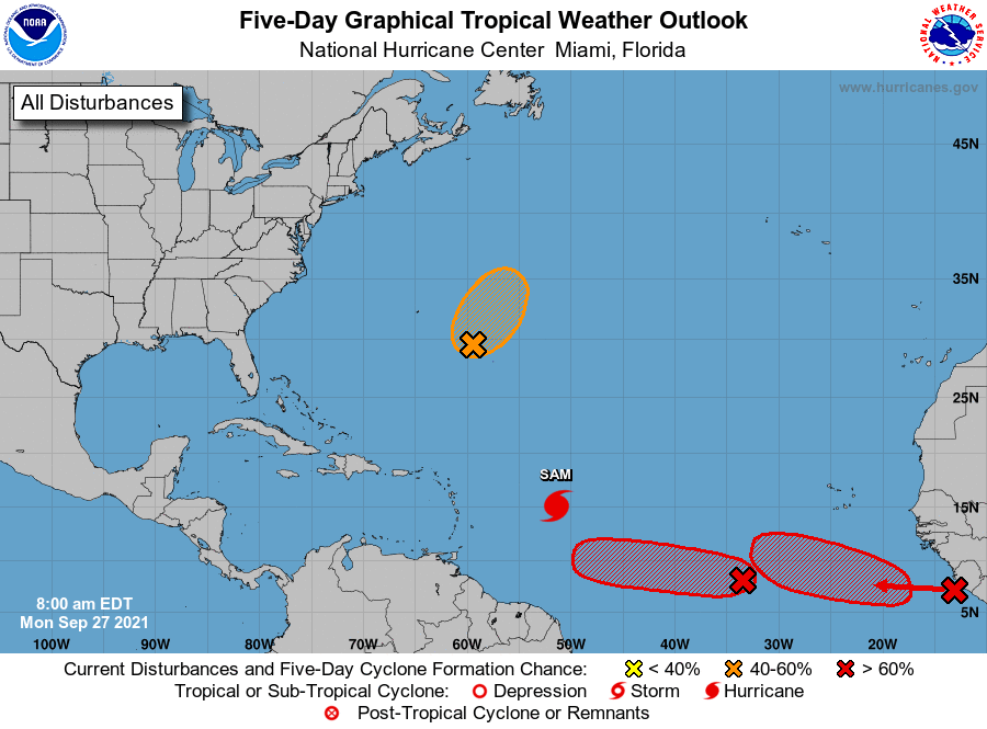
The National Hurricane Center (NHC) in Miami, Florida is busy tracking category 4 Major Hurricane Sam; however, they also forecast the possibility that three new tropical cyclones will join it in the Atlantic hurricane basin in the coming days.
With maximum sustained winds down a bit from yesterday’s peak, Hurricane Sam is still packing a punch with 130 mph winds. Fortunately, the storm is contained over water and is of no immediate threat to land. The latest forecast track from the NHC steers it away from the Northern Leeward Islands and the Bahamas but brings it dangerously close to Bermuda by next weekend. It is still too soon to know exactly where Sam will go beyond the 5 day forecast provided by the NHC with any degree of confidence.

While Sam spins about, the National Hurricane Center is tracking three other disturbances that could become tropical cyclones this week in the Atlantic Ocean. The first is in the North Atlantic well north of Sam and the other two are behind it in the eastern Atlantic.
The system in the North Atlantic is actually an elongated area of low pressure associated with the remnants of Tropical Storm Peter. It is currently located a few hundred miles east-southeast of Bermuda. Showers and thunderstorms associated with this system have changed little in organization since yesterday. However, the NHC says that environmental conditions are marginally conducive for some further development, and Peter could briefly become a tropical depression again during the next day or two while it moves northeastward near 10 mph. By midweek, environmental conditions are expected to become unfavorable for further development. Of the three potential systems, the NHC puts the lowest odds of a tropical cyclone forming here, saying there’s a 50-50 shot of formation over the next 48 hours.

An area of disorganized showers and thunderstorms are associated with a broad area of low pressure located several hundred miles southwest of the Cabo Verde Islands is likely to become a tropical cyclone though. According to the NHC, environmental conditions are forecast to be conducive for further development of this disturbance, and a tropical depression is likely to form in a few days while it moves westward to west-northwestward at 5 to 10 mph over the central tropical Atlantic. While there’s only a 40% chance of formation over the next 48 hours, the NHC believes there’s a high 80% chance that it will form over the next five days.
The third area of concern is just off the west coast of Africa. According to the NHC, upper-level winds are forecast to be conducive for gradual development of a tropical wave here as it moves off the coast of Africa. The NHC says a tropical depression is likely to form in a few days while the system moves westward to west-northwestward at 10 to 15 mph over the far eastern tropical Atlantic. Like the other system just to its west, the NHC says there’s a 40% chance of formation over the next 48 hours, but those odds grow to a high 80% over the next five days.
Elsewhere, tropical cyclone formation isn’t expected this week in the Atlantic. The Atlantic Hurricane Season runs through to the end of November.