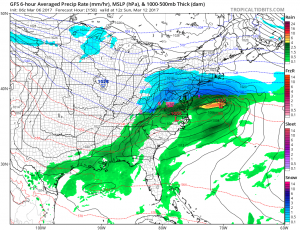
Overnight computer model forecast guidance has increased the odds of a potential snowstorm in the eastern United States for next weekend. Suggested in earlier runs of the European ECMWF forecast model, the American GFS and Canadian CMC forecast models now all suggest a significant winter storm will form next weekend along with the latest ECMWF forecast model. The devil is in the details though: while the European and American forecast models have some similarities, they bring different amounts of snow to portions of the Mid Atlantic and Northeast; the Canadian, as an outlier, has the storm system much further south than either the American or European models.
These computer forecast models are one of many tools meteorologists use to forecast the weather, but isn’t the only tool. Meteorologists look at weather patterns, recent events, and general climatology to consider if such modeled output is accurate and/or reasonable.
At this time, a snowy situation for next weekend is favored over one that isn’t snowy. But it is still far too soon to know with certainty how this storm will evolve and who will get what type of precipitation. At this time, the best chance for heaviest snow is between Washington, DC and Philadelphia, PA, including southern New Jersey, Delaware, and northeastern Maryland. It is important to point out that this area –and the forecast overall– will continue to evolve and shift over the coming days.
Important weather data needs to be digested by computer forecast models and deciphered by meteorologists in the coming days. The amount of weather data arriving in about the environment over the eastern Pacific Ocean is very limited at this time; with that limited data, knowing how the atmosphere will set-up or not over the western United States to help facilitate a storm system on the eastern United States is not completely known at this time.
Nevertheless, residents should use the “calm” before the storm to make sure they are ready for additional winter weather threats in the coming days. While February ended on a very warm note and long range guidance suggests March may end up very warm too, cold weather and winter storms are still a very real possibility as we move into the next seven days.
