Severe weather is expected in the Mid Atlantic today as a frontal system bringing cooler air collides with the steamy, hot and humid air mass that’s been in place this week.
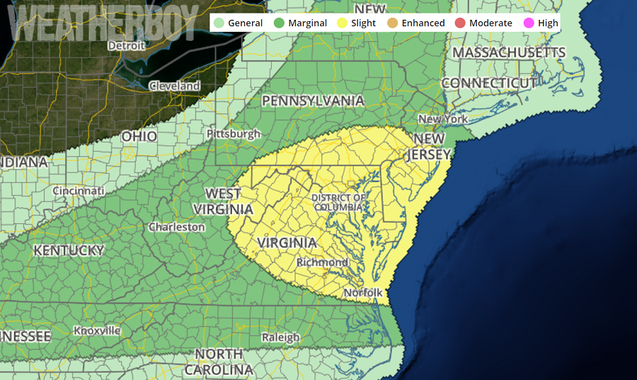
The National Weather Service’s Storm Prediction Center, in today’s Convective Outlook, identifies an area that includes southern New Jersey, southern and southeastern Pennsylvania, all of Maryland and Delaware, and the northeastern half of Virginia. The cities of Philadelphia, PA, Atlantic City, NJ, Trenton, NJ, Newark, DE, Baltimore, MD, Washington, DC, Richmond VA, and Norfolk, VA are included in this area.
According to the Storm Prediction Center, widely scattered damaging winds will be possible today across parts of the central Appalachians and Mid-Atlantic vicinity. Isolated severe storms will be possible elsewhere across portions of the eastern states to the Mid-South, across the north central states, as well as central and southern Arizona.
A mid-level shortwave trough over the Great Lakes this morning will progress east-southeastward across NY to western New England and the northern Mid Atlantic tonight. An associated surface cold front will move slowly southeastward from the Ohio Valley to the Appalachians, while a weak pre-frontal/lee trough will form across Virginia. Differential surface heating along and south of the thicker clouds and morning convection, in addition to the aforementioned boundaries, could act to focus thunderstorm development by this afternoon. Storms that form along the pre-frontal trough will have the potential to produce at least isolated damaging gusts, with somewhat more organized storm structures expected farther north toward the Maryland/Pennsylvania border, in proximity to the stronger mid-level westerlies.
Additional convection is expected along the cold front farther northwest this afternoon/evening, where damaging gusts will be the main threat.
Low-level and deep-layer shear will be strongest along a stalled front from New Jersey across eastern Pennsylvania into central New York. However, the degree of buoyancy will become more questionable with northward extent, given the ongoing convection and lingering clouds to limit
surface heating through the day. The more probable area for an embedded supercell or two will be across southeastern Pennsylvania into southern New Jersey along the boundary, close to the southern edge of the ongoing convection.
