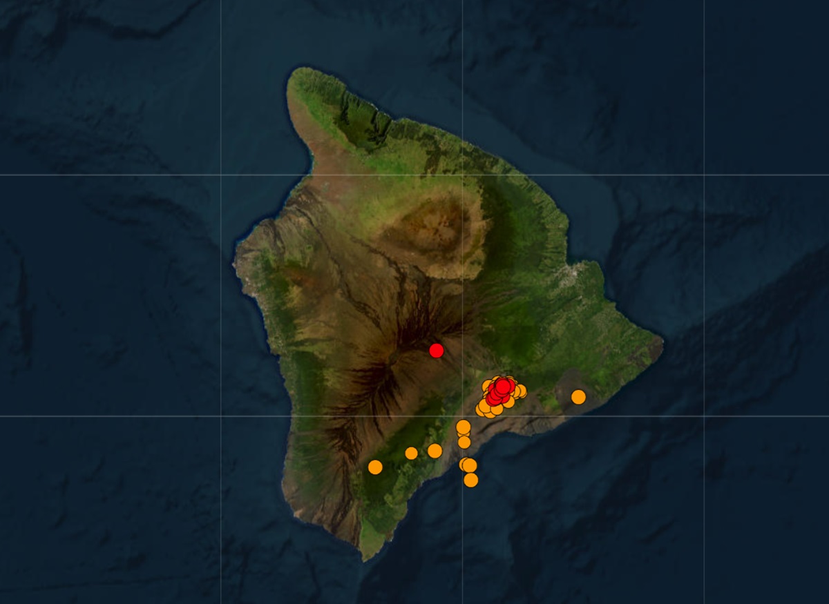
More than 220 earthquakes have rocked Hawaii in the last 24 hours; the increase in seismic activity and other signals at the Kilauea Volcano have prompted USGS scientists at the Hawaiian Volcano Observatory (HVO) to increase the volcano alert level there. While the volcano is not erupting yet as of press time, USGS warns that an “eruption can occur in the future with little warning.”
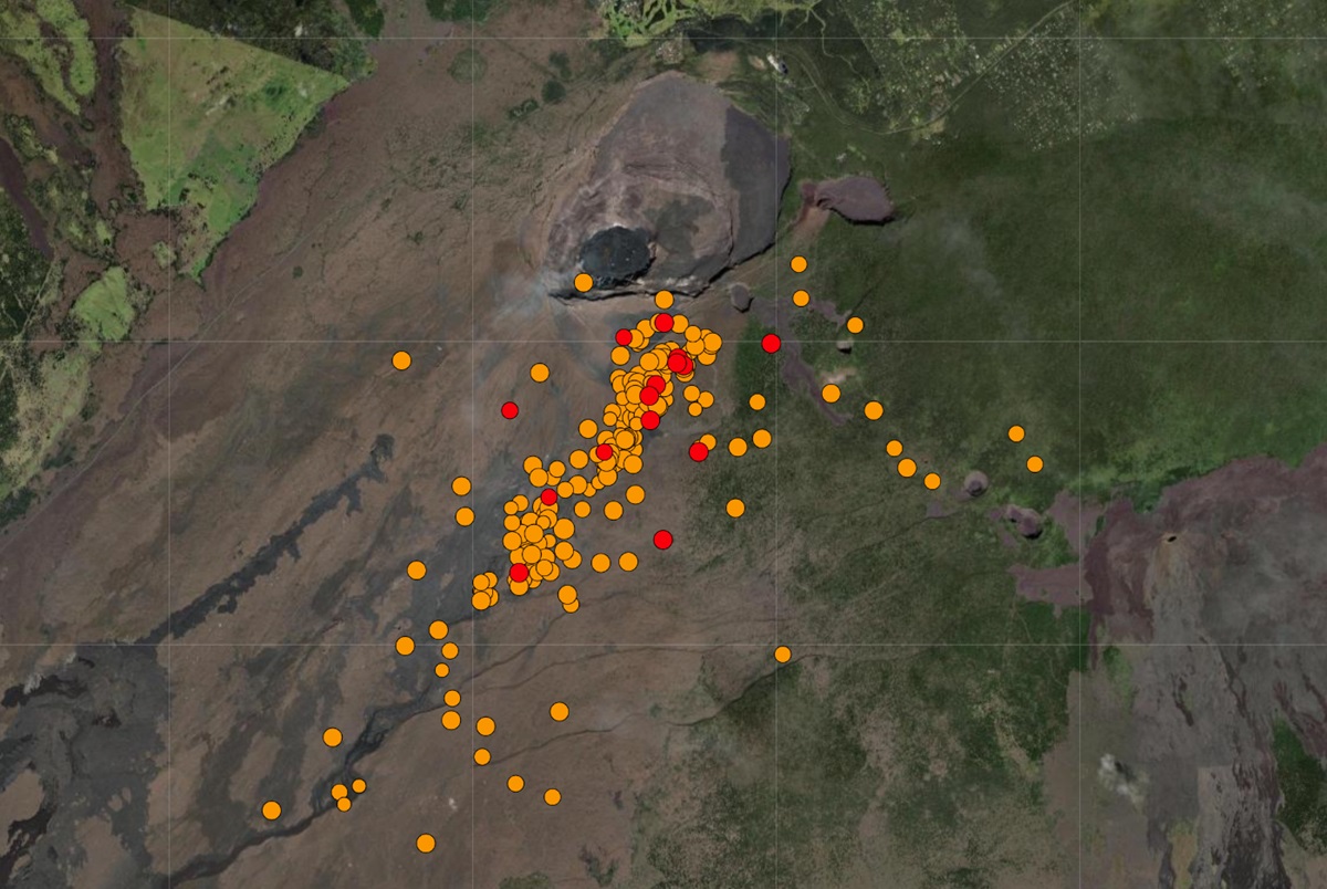
According to HVO scientists, seismicity began to increase just before midnight. Since 3 am local-time, 25-30 locatable earthquakes have occurred per hour at depths 1–2 miles below the surface. Earthquake clusters have migrated between the area just south of Halema’uma’u, a pit within the summit caldera crater, and the region southwest of the outer caldera boundary. The most intense activity occurred between 6 and 8 am when earthquakes were clustering just south of Halemaʻumaʻu. There have been over 180 locatable earthquakes in this region in the past 6 hours, with magnitudes ranging from a maximum of 3.4 to less than 1. Several of these earthquakes were large enough to be felt by HVO staff in the field, who also reported rockfalls on the south side of Halemaʻumaʻu.
There have been 502 earthquakes on the Big Island of Hawaii over the last 7 days; 228 of those have happened in the last 24 hours.

Patterns of ground deformation and earthquakes since this morning indicate that pulses of magma continue to move beneath the surface of the region south-southwest of Kilauea’s summit. Scientists at the volcano are closely monitoring it, watching for any signs of accelerated rates of earthquakes or ground deformation, or signs of shallowing earthquake locations, which usually precede a new outbreak of lava or propagating dike.
AVO says Kilauea’s summit region remains at a high level of inflation. In an update released a short time ago, AVO reports, “Nearly 10 microradians of change have been recorded since 4:00 am at tiltmeters near Sand Hill and Uēkahuna bluff. Both of these tiltmeters have shown highly variable directions and rates of tilt, typical of shallow crack growth that can precede either an eruption or shallow intrusion. Step-wise changes in the tilt signal are likely due to the instrument being shaken by nearby earthquakes or rockfalls.”

Sulfur dioxide (SO2) gas emission rates remain low. Field measurements indicated an SO2 emission rate of approximately 70 tonnes per day on January 17, which was similar to measurements in October, November, and early December.
Due to the seismic activity and detection of magma movement leading to ground deformation, USGS raised the volcano alert level from ADVISORY to WATCH and the aviation color code from YELLOW to ORANGE. This change became effective at 4:41 am local time today.
In the U.S., the USGS and volcano observatory units are responsible for issuing Aviation Codes and Volcanic Activity Alert Levels. Aviation Codes are green, yellow, orange, or red. When ground-based instrumentation is insufficient to establish that a volcano is at a typical background level of activity, it is simply “unassigned.” While green means typical activity associated with a non-eruptive state, yellow means a volcano is exhibiting signs of elevated unrest above known background levels. When a volcano exhibits heightened or escalating unrest with the increased potential of eruption, it jumps to orange. Finally, when an eruption is imminent with significant emission of volcanic ash expected in the atmosphere or an eruption is underway with significant emission of volcanic ash into the atmosphere, the code becomes red. Volcanic Activity Alert levels are normal, advisory, watch, or warning. As with aviation codes, if data is insufficient, it is simply labeled as “unassigned.” When the volcano is at typical background activity in a non-eruptive state, it is considered normal. If the volcano exhibits signs of elevated unrest above background level, an advisory is issued. If a volcano exhibits heightened or escalating unrest, a watch is issued while a warning is issued when a hazardous eruption is imminent.

In a Volcanic Activity Notice issued this morning, HVO said they were in constant communication with Hawai‘i Volcanoes National Park as this situation evolves adding that this latest surge of activity is confined entirely within the park. “HVO continues to closely monitor this activity. Should activity change significantly, a new Volcanic Activity Notice will be issued,” wrote HVO in their Notice.
As of the time of this publication, there were no road or trail closures within the national park territory that surrounds Kilauea Volcano.
According to USGS, Kilauea summit eruptive activity over the past several years has occurred at the base of Halemaʻumaʻu crater and on the downdropped block, within the closed area of Hawai Volcanoes National Park. During Kilauea summit eruptions, the high level of volcanic gas—primarily water vapor (H2O), carbon dioxide (CO2), and sulfur dioxide (SO2)—being emitted is the primary hazard of concern, as this hazard can have far-reaching effects downwind elsewhere on the Big Island of Hawaii and even on neighboring islands of Maui and Oahu.
Passive volcanic degassing can occur from within Halemaʻumaʻu crater even during periods of no eruptive activity. As SO2 is released from the summit, it reacts in the atmosphere to create the visible haze known as vog (volcanic smog) that has been observed downwind of Kīlauea. Vog creates the potential for airborne health hazards to residents and visitors, damages agricultural crops and other plants, and affects livestock.
Other significant hazards also remain around Kilauea caldera from Halemaʻumaʻu crater wall instability, ground cracking, and rockfalls that can be enhanced by earthquakes within the area closed to the public. USGS says, “This underscores the extremely hazardous nature of the rim surrounding Halemaʻumaʻu crater, an area that has been closed to the public since early 2008.”