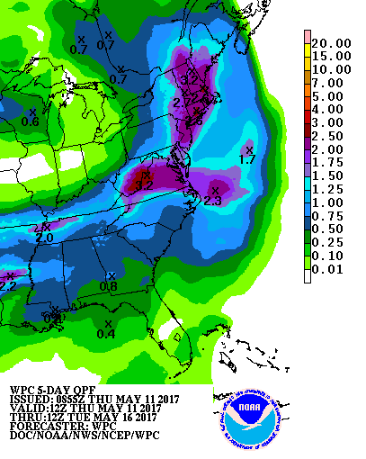
A potent Nor’Easter will bring wind-swept heavy rains to portions of the Mid Atlantic and New England coast just in time for Mother’s Day Weekend.
On Friday morning, three upper-level lows will influence the weather in the eastern United States. The first will be an increasingly progressive southern-stream vort max centered in the mid-south. The second will be a large cyclone low over the northwestern portions of the Atlantic Ocean. The third will be a slowly digging deep trough in southeastern Connecticut. As the southern stream system moves east into the Tennessee Valley on Friday night, it’ll interact with the Canadian trough . With downstream ridging promoting difluent flow aloft, the attendant surface low in the southeastern US will rapidly strengthen.
This rapidly strengthening area of low pressure at the surface will move on from the DelMarVa Peninsula. With a high-amplitude ridge over the Canadian coastline, the storm system won’t be quick to exit. Because of this, there will be a long-duration onshore fetch for the Mid Atlantic and southern New England areas from late Friday night to Sunday. A variety of atmospheric ingredients will come together to produce a very heavy rainfall event for this region for the weekend.
While there is much better run-to-run model agreement and better alignment between models, there are still subtle differences in computer forecast model data with how this storm set-up will evolve. The European ECMWF model is a bit weaker and slower with this system. The short-duration, high-resolution American NAM moves the storm quicker to the east. The American GFS and Canadian CMC appears to have the most reasonable and likely the most accurate solution, bringing a soaking rain storm up the coast.
Rainfall from this storm will be a roughly 36 hour event for most people. Depending on where that 36 hours of wind and rain falls, some may be able to salvage a portion of their weekend. In the southern Mid Atlantic, precipitation will arrive during the PM hours on Friday; meanwhile, in southeastern New England, conditions will remain dry. Rain will push up the coast on Saturday, with the heaviest rain expected from Washington, DC to New York City then. Rain will eventually push into Boston and southern New England during the PM hours on Saturday. While rain will pour on Boston on Sunday, it’ll be dry in Washington, DC. Places like Delaware, eastern Pennsylvania, New Jersey, and the New York City metro area will begin to dry out early Sunday while the rain slides further up the coast.
The heaviest rain will be along and southeast of I-95 from Washington, DC to Boston, MA. Here, 1.5-3″ of rain is likely to fall, with some 3-4″ amounts possible in isolated areas. This heavy rain on top of recent rains may create flooding issues. Flash flooding, urban flooding, and areas that flood due to poor drainage are of greatest concern. There may also be some convective activity on the southern side of this storm; the threat of thunderstorms should remain over southern New Jersey, Delaware, and coastal Maryland/Virginia. Elsewhere, this will be more of a rain storm than a thunder storm kind of event.
In addition to rain, it will be very windy. The strongest winds from this storm will be in New Jersey along and east of the Garden State Parkway, across Long Island, and across Rhode Island and eastern Massachusetts. Winds here will be sustained in the 25-35mph range with some gusts in excess of 40mph possible.

A nor’easter at this time of year can produce more damage than a nor’easter during the winter, even if it’s weaker. In the fall and winter, trees are very aerodynamic when most leaves have dropped. Frozen and/or dry soil also tends to anchor tree roots well. But in the spring and summer, when leaves are out, trees no longer are very aerodynamic. Each leaf acts as a sail or parachute, putting significant forces onto a tree and its branches. As such, a 25mph sustained wind against trees in the spring may do more damage than 35mph sustained winds in the winter. While this won’t be a major wind storm with widespread wind damage, we do expect some trees to topple in wet soil with strong gusty winds and expect some tree limbs to fail under the stress of the wind. This could lead to power outages, especially closer to the coast. Other objects should be protected from the wind: lawn and patio furniture, toys, decorations, and garbage cans should all be secure before the storm strikes on the weekend.
There are also concerns for the immediate coast. With moderate winds and rough surf, there will be coastal flooding and beach erosion to deal with. Those in areas prone to coastal flooding should be prepared to take action well before flood waters rise.
Because the storm will continue to strengthen as it moves north and east, strong northwest winds will wrap around the back side of this storm as cold air advection kicks in. While the rain will be gone, gusts in the 30-40mph+ range are possible on Sunday for places like New Jersey, Philadelphia, and New York City. However, downsloping should counter the cold air advection which would help keep temperatures stable if not warmer on Sunday compared to Saturday as the storm exits.