
While this set-up is more common in the middle of July rather than the middle of May, it isn’t completely out of the norm: a strong frontal system is moving into a summer-like airmass in the northeast, setting off a round of severe and potentially violent weather. In the latest National Weather Service Storm Prediction Center Convective Outlook, meteorologists there believe there is an enhanced risk of severe storms across much of New York, Vermont, and northern New Hampshire.
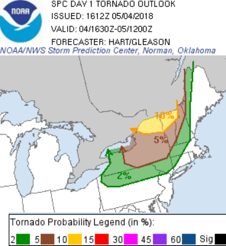
In addition to the threat of severe thunderstorms, there’s also an enhanced threat for tornadic storms across northern New England. There is a 10% probability of tornadoes over northern New York, Vermont, and New Hampshire, which represents a probability many times higher than normal. According to the Storm Prediction Center, this is the first 10% tornado forecast to include any part of New Hampshire or Vermont since a Moderate Risk on September 8, 2012. Other 10% tornado risks since 2010 include May 26, 2011 and June 6, 2010.
Strong to severe storms are possible as far south as Delaware, Maryland, and Virginia this evening as the frontal system moves through. The National Weather Service has raised Tornado Watches and Severe Thunderstorm Watches for portions of the northeast; these may expand south and east this evening as the front moves through. People in the watch areas should be ready to take immediate action should a Severe Thunderstorm Warning or Tornado Warning be issued for this area.
Once the front exits the region, fair, dry, and cooler air will return. However, in places like New Jersey, while it will be noticeably colder than today, it will still be about 5 degrees above normal for this time of year.
