After a powerful coastal storm brought flooding rains and damaging winds that created the most widespread power outage since 2012’s Hurricane Sandy, cold air is surging into the Eastern United States. The result will be November will kick off on a chilly, frosty note for many.
As the storm responsible for this morning’s rain and win moves into the Canadian Maritimes, a fast southwest mid-level flow will overtake the northeast tonight, drying out the region of the previous precipitation field. The difference in pressure between the arriving ridge of high pressure and the departing low pressure storm system will relax, allowing winds to diminish. However, there will be just enough wind to prevent temperatures falling too much tonight despite clear conditions.
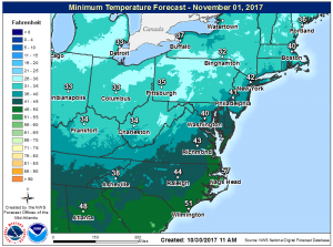
Clear conditions and calm winds will help temperatures drop further on Halloween night, setting the stage for a very cold morning on the first day of November. Near the Great Lakes region, wake-up lows will be in the 20’s. Lows in the upper 20s are also expected for the Poconos in eastern Pennsylvania, the low to mid 30s for most of New Jersey and southeast Pennsylvania, including Philadelphia, and upper 30s to low 40s for the New York City metro area. The urban corridor from Trenton, New Jersey to Wilmington, Delaware will be several degrees warmer, generally in the upper 30s to low 40s, and lows will be in the mid to upper 30s in the Delmarva. Temperatures just outside this corridor will be many degrees colder, ending the growing season for most of the Garden State. If clouds don’t stream ahead of the next weather system quickly, temperatures could drop another 5-10 degrees in this region. Coastal New England will remain a few degrees normal than inland temperatures due to the relatively milder waters of the nearby Atlantic. Further south, temperatures will drop into the upper 30’s as far south as central and western Virginia, western North Carolina, and central Tennessee. Temperatures in central North Carolina, northwestern South Carolina, and northern Georgia will also be chilly with wake-up temperatures only in the 40s there.