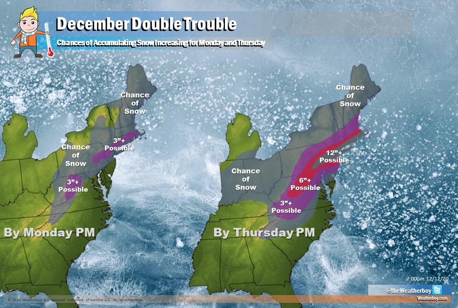
Odds are increasing that there will be double winter storm trouble for portions of the eastern United States next week. While it is still too early to say how exactly these storms will come together and who will get how much snow, it is becoming more and more likely that these storms will evolve and impact the east and odds are increasing that the second storm system could pack quite the punch.
The first storm is expected to unfold Monday into Tuesday while the second storm will unfold Wednesday into Thursday from southwest to northwest.
A low pressure system will lift from the Great Lakes into Quebec this weekend, with a cold front associated with the low crossing the Mid Atlantic tomorrow. Another low is expected to cross from the Carolinas off the Delmarva coast on Monday. A more potent low is expected to develop off the Georgia coast late Tuesday, then quickly lift northeast into the Mid Atlantic by Wednesday and the New England coast by Thursday.
The first system will produce more rain than snow, and where it snows, snow should be relatively light. While there’s a chance of accumulating snow from the Appalachians into central Maryland and Pennsylvania, northern New Jersey, and much of New England, most of it should be light. The exception will be an area just north and west of New York City from the Poconos into southern New England; there; more than 3″ of snow could accumulate. More than 3″ of snow is also possible for the higher terrain of West Virginia. Below this snow area, from central New Jersey south, rain will be the dominant precipitation type. However, across the southern half of New Jersey and northern Delaware, the rain could briefly change to snow before ending; no significant accumulations are expected from that possible wintry mix.
The second storm system will bring much more precipitation; this storm will also have colder air to work with. As such, heavier snow over a broader region could be possible. While amounts will be determined by eventual storm track, it appears the the heaviest snow could fall from near Philadelphia through the New York City metro area to the southern Boston suburbs. Here, 12″ or more could snow if the right amount of cold air and moisture mixes; if the timing is perfect, there’s even a chance that the snowfall here could be significantly higher than a foot. Lighter snows will fall to the north on the northern fringe of the storm. Less snow will fall on the south side of the storm where snow could start out as, mix with, or change to rain at times, especially over southern Delaware and eastern Maryland.
In addition to the threat of heavy snow, very strong winds and coastal flooding could also be threats from this second storm. Most impacts will be over on Wednesday, but there will be lingering snow shower activity in portions of New England by Thursday. Winds will gradually diminish on Thursday too as the storm system heads out to sea.
Computer forecast models that meteorologists use to aid in forecasting have aligned to the idea that these two storms will form and impact the eastern U.S. There are subtle differences though between models and between model runs, with some suggesting more or less precipitation and more or less cold air. As such, there could be significant changes in who gets how much snow in the coming days. It should become clear by late Sunday night how much precipitation and what precipitation type will fall during the Monday system; by Monday night, there should be forecast clarity around the Wednesday/Thursday system.