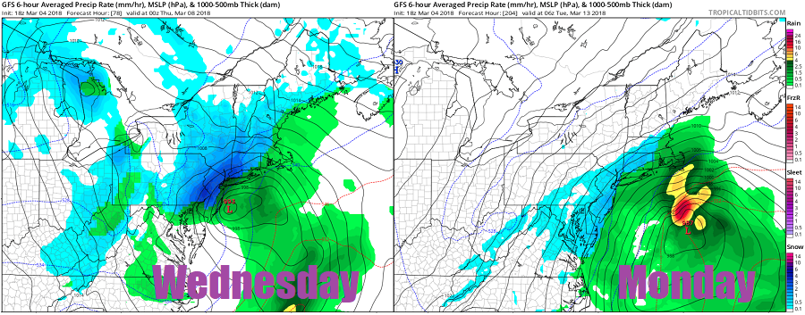
With recovery efforts continuing in the wake of the Monster March storm that killed 9 people and left hundreds of thousands without power, eyes are on not one, but two additional systems that will likely bring havoc to an area that doesn’t want nor need it. Additional heavy wet snow and a fresh round of high winds could be in the cards for Wednesday; with already damaged trees and root systems, a stressed power grid, and significant coastal erosion, the next storm expected to impact the northeast on Wednesday could be quite significant. To make matters even worse, an additional system is likely to impact the beleaguered area just days later.
The new work week will start out on a quiet note. High pressure will be in control of the weather across the northeast, providing dry and seasonably cold conditions to the region. On Tuesday, the day will start off quiet and dry as the high pressure system shifts off-shore out to sea. In the Mid Atlantic, clouds will increase throughout the day with light precipitation spreading from north to south on Tuesday.
Wednesday appears to be impact day for many across the northeast. While confidence is high that another high-impact storm will strike the northeast, confidence is low in the storm specifics: additional data and analysis will be needed to determine precipitation types and amounts. A coastal low pressure system will develop along the North Carolina coast late Tuesday night and early Wednesday, becoming better organized and stronger as it moves up the coast. By Wednesday night, the center of this storm system should be off the New England coast. As it moves up the coast, another round of wind-whipped heavy precipitation is likely in the northeast. While forecast specifics need to be refined, it appears this storm will be colder than Friday’s, resulting in more snow, especially in southeastern and interior New England. Heavy snow could also make its way into eastern Pennsylvania, New Jersey, and the New York City metro area, although confidence in significant snow is greater north of that area than in it.
The National Weather Service office in Mount Holly, New Jersey cautions, “This storm does show similar qualities to the recent nor`easter across our region but current model projections have the storm weaker and much more progressive. However, this does not mean the storm will be less impactful across the region.” What those impacts can be will take a few days of data-crunching to figure out.
Temperatures are going to play a huge role in the outcome of this Midweek Mayhem system and the proximity to the coast will be a driving force. While the system will be tapping into some nearby cold air, the storm may be strong enough to bring cold upper level air down to the surface, keeping precipitation more white than wet. The potential for a significant accumulating, wet snow is there. And like Friday’s storm, this snow will have a very heavy, wet consistency that on its own could create problems for tree limbs and/or wires. Because this system should be rich with moisture, some places may see more than 1-2 feet of snow; the greatest threat of heavy snow remains over interior southeastern New England. Whether that heavy area makes it way closer to the I-95 corridor and to the cities along it remains to be seen.
Beyond the threat of heavy snow, strong winds will be making a return too. Winds will be gusty in the Northeast and Mid Atlantic, possibly up to 40mph along the coast and 30 to 35 mph inland. Such winds may bring some wires, tree limbs or trees down, especially as the ground is
already wet with limited drying occurring. And because many trees and their root systems were damaged in Friday’s storm, many may not be able to withstand much more wind. Coastal flooding will likely return, but with winds not as prolonged as they were with Friday’s system, flooding should be minor to moderate at worst.
Once this next storm exits the United States on Thursday, eyes will be on the next potential storm. High pressure will return to the northeast from Thursday to Sunday. After Sunday, clouds will increase once again with another coastal storm likely to move up the Mid Atlantic and New England coast. While even less is known about that storm than the next one on the way, it bears watching; with cold air around and the ability to create another windy nor’easter with heavy precipitation, the threat of storm damage will linger into next week too.