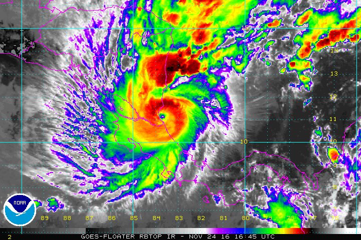
Hurricane Otto, a well defined Category 1 hurricane, will strike Central America today.
In the last update from the National Hurricane Center this morning, the eye of Hurricane Otto was located near latitude 11.0 North, longitude 83.4 West. Otto is moving toward the west near 9 mph (15 km/h), but a faster motion toward the west or west-southwest is forecast to begin tonight and continue through early Saturday. On this track, the center of Otto will make landfall within the hurricane warning area during the next several hours, and then move across southern Nicaragua and northern Costa Rica through this evening. The center of Otto is expected to reach the Pacific coast of southern Nicaragua or northern Costa Rica tonight or early Friday.
An Air Force Reserve Hurricane Hunter plane penetrated the eye of Otto this morning and indicated that the hurricane was intensifying. The estimated central pressure dropped
to 976 mb and the flight-level wind at 700 mb peaked at 108 kt while the SFMR winds reached 90 kt. Since that time, satellite imagery showed that the hurricane cloud pattern has become better organized with a distinct eye in both convectional and microwave imagery, and the Data-T numbers reached 5.5 on the Dvorak scale. On this basis, the initial intensity has been set at 95 kt.
There is an opportunity for some additional strengthening before Otto makes landfall during the next several hours. However, weakening should begin after the eye moves farther inland across Central America. Otto is expected to emerge over the eastern Pacific in about 12-24 hours as a tropical storm. Otto should continue to weaken as it moves over the eastern pacific given that strong shear is forecast to prevail in that region, and the cyclone should become a remnant low by the end of the forecast period. The National Hurricane Center intensity forecast is very similar to the previous one.
Satellite and reconnaissance fixes indicate that Otto is moving toward the west or 270 degrees at 8 kt. The hurricane is trapped within easterly flow associated with a strong high pressure to the north, and since this high is forecast to persist, the hurricane should continue on a general west to west-southwest track for the next 3 days. After that time, a much weaker Otto should turn to the west-northwest around the western edge of the high. The track guidance is very consistent with this scenario and there is no need to deviate from the previous NHC forecast. The forecast track continues to be very close to the multi-model consensus.
A Hurricane Warning is in effect for:
* Limon Costa Rica to Bluefields Nicaragua
A Hurricane Watch is in effect for:
* North of Bluefields to Sandy Bay Sirpi Nicaragua
* South of Limon to the Costa Rica/Panama border
A Tropical Storm Warning is in effect for:
* North of Bluefields to Sandy Bay Sirpi Nicaragua
* Puntarenas Costa Rica to Puerto Sandino Nicaragua
Many threats are arriving with this landfalling hurricane:
Rainfall
Total rainfall of 6 to 12 inches, with isolated amounts of 15-20″, can be expected across northern Costa Rica and southern Nicaragua through today. These rains will likely result in
life-threatening flash floods and mudslides. Outer rain bands from Otto are expected to produce rainfall accumulations of 3-6″ with total rainfall amounts of up to
10 inches over the higher terrain of far western Panama and southern Costa Rica through Friday. Additional rainfall amounts of 1-3″ can be expected today over San Andres and Providencia Islands.
Wind
Hurricane conditions are expected to reach the hurricane warning area during the next several hours, while tropical storm conditions are likely to be occuring already. Hurricane conditions are possible in the hurricane watch area today. Tropical storm conditions are likely occurring within the warning area on the Caribbean coast of Nicaragua. Tropical storm conditions are expected in the warning area along the Pacific coasts of Costa Rica and Nicaragua by this evening.
Storm Surge
The combination of a dangerous storm surge and large and destructive waves could raise water levels by as much 4 to 6 feet above normal tide levels in areas of onshore flow within the hurricane warning area.
SURF
Swells generated by Otto are likely to cause life-threatening surf and rip current conditions over the next several days along the
coasts of Panama, Costa Rica, and Nicaragua.
Visit our Tropical Weather Page here for further information about this system and a review of all tropical cyclones that were near US waters for the 2016 season: https://weatherboy.com/hurricanes-tropical-weather/