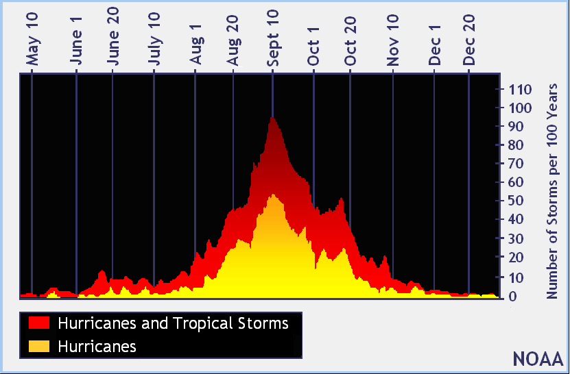
Today marks the typical peak of the Atlantic Hurricane season which begins on June 1 and runs through the end of November. Typically, this date marks more tropical cyclone activity in the basin more so than any other date when records of the last 100 years are studied.
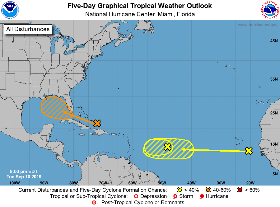
While today is the peak of the season, the basin has no named storms. However, the National Hurricane Center is tracking three potential threats. A surface trough located over the Turks and Caicos is producing widespread cloudiness and disorganized thunderstorms over the Turks and Caicos and the southeastern Bahamas, and extending northward over the southwestern Atlantic for a few hundred miles. Ship reports indicate that tropical-storm-force wind gusts are occurring in some of the heavier squalls. According to the National Hurricane Center (NHC), limited development of this disturbance is expected during the next few days while the system moves slowly west northwestward across the Bahamas due to only marginally conducive upper-level winds. However, the NHC says environmental conditions could become more favorable for development when the system moves over the Florida Straits and into the eastern Gulf of Mexico late this week and over the weekend. Regardless of development, this disturbance will produce periods of locally heavy rainfall and gusty winds across the Bahamas through Thursday, and across Florida on Friday and continuing into the weekend. The NHC says there’s a 40% chance that this area will become a tropical cyclone over the next five days.
The remaining two threat areas are far away from land. A broad low pressure system, associated with a tropical wave, is located about 900 miles east of the Lesser Antilles. Although this disturbance continues to produce disorganized shower activity, some slight development of this system is still possible tonight and Wednesday. By Thursday, however, upper-level winds are forecast to become unfavorable for tropical cyclone formation. This disturbance is expected to move slowly westward across the tropical Atlantic Ocean for the next several days. The NHC believes there’s only a 20% chance this area will develop into a tropical cyclone in the coming five days. The other tropical wave is located between the west coast of Africa and the Cabo Verde Islands. It is expected to move quickly westward during the next several days. Some slow development is possible over the weekend when the system is a few hundred miles east of the Windward Islands. As with the other system, the NHC believes there’s a 20% chance this system will develop into a tropical cyclone over the next 5 days.

While the NHC doesn’t believe this second system will develop over the next 5 days, global computer forecast guidance, such as the American GFS model, does suggest a tropical cyclone will form from it over the next week. It suggests portions of the Caribbean, the Bahamas, and the U.S. East Coast could see direct or indirect impacts over time.
Elsewhere in the Atlantic basin there is no sign of tropical development in the next few days. The same is true for the Central Pacific Hurricane Basin which surrounds Hawaii.
