A potent winter storm will bring snow, wind, and rain to portions of the Mid Atlantic and Northeast tomorrow, with some areas likely to see wind damage, heavy snow, and perhaps both. A potent cold front undergoing significant frontogenesis is the reason behind the storm, which will cross through portions of the Northeast and Mid Atlantic with a mixed bag of precipitation, some of it heavy. The system will also produce strong winds and tidal flooding concerns.
On Sunday morning, the cold front will be draped across much of the Appalachian range and will progress eastward throughout the day. Precipitation will arrive from west to east near the I-95 corridor, with moderate to heavy rain moving in by the late afternoon hours. While the rain comes, so will the winds; winds will be 15-20 mph sustained with gusts of 30-45 mph possible. Those higher gusts of 40-45 mph will be felt closer to coastal areas and gusts into the 50 mph range can’t be ruled out.
Strong warm air advection ahead of the cold front will surge warm air from south to north well into New England. This will keep the precipitation in liquid form for most except those in colder areas of northern New England.
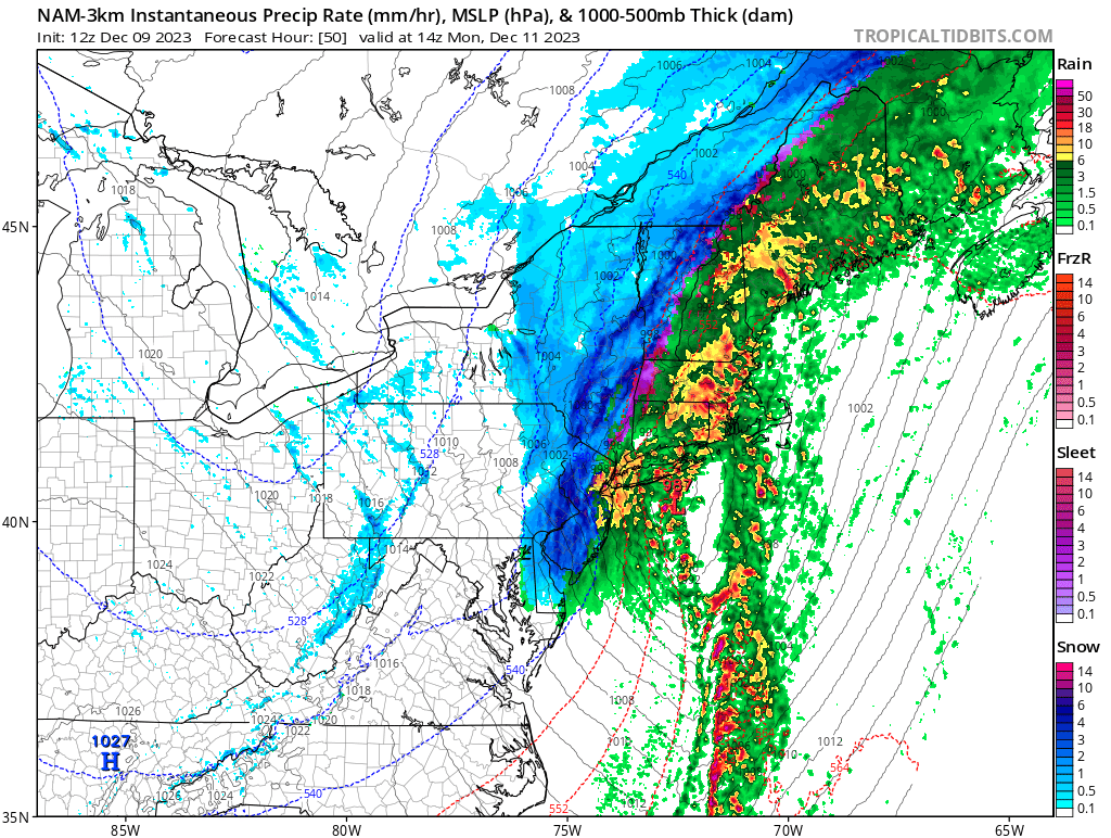
On Sunday night, the cold front will swing east and eventually clear the coast. At and around this time is when rain and wind will be the most intense. Some strong thunderstorms also can’t be ruled out, although the primary threat from the storm will be wind damage rather than hail or tornado threats. Rain fall may approach 2-3″ near and east of the I-95 corridor.
As the cold front clears the coast, though, temperatures will drop sharply by daybreak Monday. As cold air wraps around the storm, the precipitation will change to snow over New England and some of that snow will be heavy at times. Snow is also likely to fall as far south as New Jersey, Pennsylvania, Virginia, and West Virginia, although the snow will mix with rain at times on the southernmost side of the precipitation shield. Monday morning, rain showers will turn to snow flurries for places like Philadelphia and New York City, where no snow accumulations are expected. However, north of there, several inches of snow are expected.
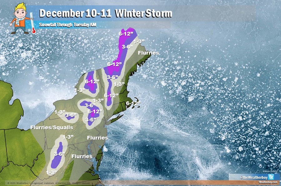
1-3″ of snow is expected over portions of northern New Jersey, northeastern Pennsylvania, and portions of central New England. Higher terrain will see more snow, with 3-6″ possible there and some isolated amounts of 6-10″ possible too, with the greatest amounts on the highest, coldest peaks. Several inches of snow may also fall over the higher terrain of eastern West Virginia.
With strong high pressure building in from the southwest and a deepening coastal low to the northeast being triggered by the front reaching the coast, pressure gradients will tighten during the day Monday, resulting in a strong surge of west-northwest airflow across the northeast. Winds during the day Monday will likely gust 30-40 mph across inland locations as well as along the shore. Winds will make colder temperatures feel even colder.
By Monday night, high pressure will gain a stronger foothold across the northeast allowing clouds to break overnight and winds to relax to around 10-15 mph with a few gusts still reaching 20 mph. Temperatures will be much colder with overnight lows dropping into the mid 20s, standing in sharp contrast to the relatively mild temperatures expected ahead of the frontal passage on Sunday.
