
An unusually strong atmospheric river (AR) poured heavy rain across Arizona and southern Utah on Sunday, pushing creeks and washes toward flood stage on ground already soaked by weeks of storms and prompting forecasters to warn of numerous flash floods through Sunday night.
Flood watches covered much of central and eastern Arizona, including the Phoenix metro area, and parts of southern Utah, the National Weather Service said, and flood warnings were in effect Sunday morning near Phoenix, along Oak Creek near Sedona and in the slot canyon country around Zion and Bryce Canyon national parks.
“Is this the Desert Southwest of the Pacific Northwest?!” forecasters at the weather service office in Phoenix wrote in their Sunday morning discussion. They called it “one of the strongest ARs, in terms of IVT, to hit the Desert Southwest over the last decade,” referring to integrated vapor transport, a measure of how much water vapor a storm carries.
The Weather Prediction Center, part of the National Weather Service, placed portions of Arizona and southern Utah under a Moderate Risk, level 3 of 4, for excessive rainfall on Sunday. A second Moderate Risk area covered part of the Four Corners region farther east.
In its outlook issued early Sunday, the center said moisture levels were 4 to 6 standard deviations above normal for this time of year and that “essentially all of the Southwest has been in a very wet period.” Because soils are already saturated, the center said, “all of today’s rains will be converting to runoff, leading to numerous instances of flash flooding.”
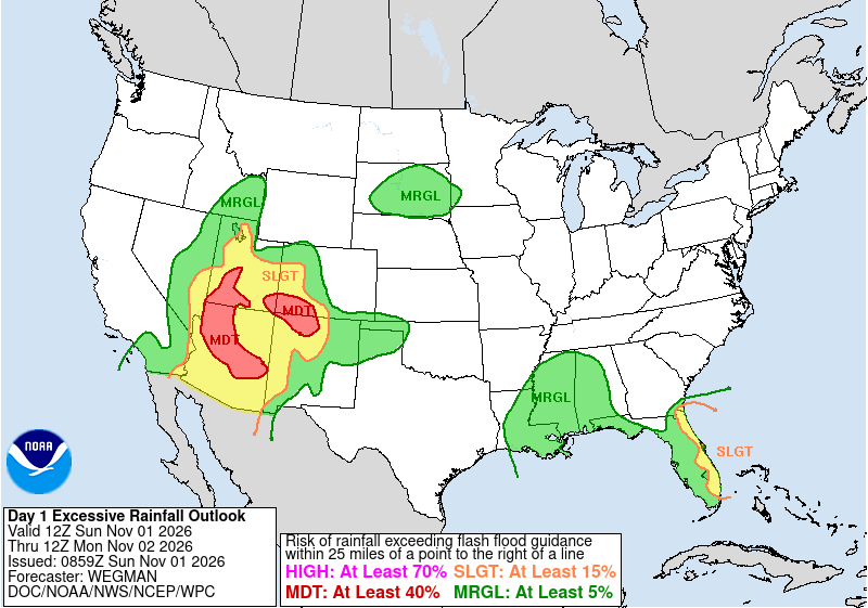
How Much Rain is Expected
The Weather Prediction Center forecast a widespread 3 to 5 inches along the Mogollon Rim, the long escarpment that crosses central Arizona, with the highest-end risk mainly north and east of Phoenix.
The weather service office in Flagstaff said widespread areas of northern Arizona would see 1 to 3 inches, with some spots along and south of the Mogollon Rim getting 4 to 6 inches. “This is a serious situation,” the office wrote. “Stay away from waterways. Turn around, don’t drown.”
The Phoenix office said 0.5 to 1.5 inches of rain fell across central Arizona on Saturday evening and night. It expected 0.5 to 1.5 inches or more across the lower deserts on Sunday and more than 2 to 3 inches in terrain north and east of the city.
In Utah, the Salt Lake City office said up to 3 inches of additional rain was possible in favored terrain of southern Utah and more than an inch in lower elevations, including St. George, Cedar City, Zion Canyon and Kanab.
Rivers and Creeks on the Rise
The weather service’s flood warning for parts of Coconino and Yavapai counties said 1 to 2.25 inches of rain had already fallen by early Sunday. Oak Creek at Cornville, which stood at 2.67 feet at 4 a.m., was forecast to crest at 11.91 feet at 8 p.m. Sunday, well above its flood stage of 8 feet. Oak Creek at Sedona was forecast to crest at 13.94 feet, just below its 14-foot flood stage.
The Verde River near Camp Verde was forecast to crest at 14.65 feet at noon Monday, below its 17-foot flood stage, the warning said. It listed Cottonwood, Sedona, Verde Village, Clarkdale and Cornville among places that could see flooding, along with sections of state routes 89A, 179 and 260 and swimming holes such as Slide Rock.
Near Phoenix, flood warnings issued Saturday for upstream dam releases covered the Salt River near Granite Reef Dam and Tempe Marketplace, and Rio Verde and Fort McDowell below Bartlett Dam, through Monday morning. The Phoenix office said the Salt River Project had been releasing water into the Verde and Salt river systems.
In Gila County, flooding was ongoing along Tonto Creek, and the weather service said Bar X Crossing and other low-water crossings would likely become impassable.
Slot Canyons and National Parks in Utah
In southern Utah, flood warnings issued early Sunday covered Zion National Park, Springdale and Rockville after the North Fork of the Virgin River rose to 700 cubic feet per second within 30 minutes. Others covered the Escalante River’s slot canyons, Bryce Canyon National Park, the Paria River and Buckskin Gulch. “Backcountry roads may be impassable,” one warning said.
Rescues, and One Death, Before the Main Event
Rescues began Friday, before the atmospheric river arrived. ABC15 in Phoenix reported that rescue crews saved six people after four vehicles got stuck in a wash near 40th Street and Camelback Road, and that Scottsdale crews responded to at least six vehicles trapped in floodwater.
“Water can look like it’s not moving very fast, and just a few inches is fast enough. It was enough water to move your car. It could stall you out,” Capt. Mike Johnson of the Phoenix Fire Department said, according to AZFamily. “Our ground is already saturated,” he said.
In Henderson, Nevada, outside Las Vegas, fire crews responded to three water rescues Friday. A person pulled from a wash went into cardiac arrest and died at a hospital, city officials said, according to FOX5 Las Vegas and KTNV.
A Wet Autumn Across the Region
The storm caps weeks of heavy rain in the Southwest. Joshua Schank, lead forecaster for the weather service office in Flagstaff, told Bloomberg News: “Our main concern is just how saturated soils are already. It can’t hold the moisture it’s already had to contend with over the last three to four weeks.”
Bloomberg reported that storms beginning Oct. 20 caused catastrophic flooding along the San Juan River in the Four Corners region and that at least two people were found dead after the rains receded. New Mexico officials have said recovery costs there may exceed $200 million, the news service reported.
When It Ends
Rain was expected to end by sunrise Monday as drier air moves in behind the storm, the Phoenix office said. But runoff will keep waterways high. “Even after the rain is all done the runoff may continue through the first half of this week,” forecasters wrote.
The Flagstaff office said river flooding would likely linger for several days. The office urged residents to “have a way to receive warnings.”
