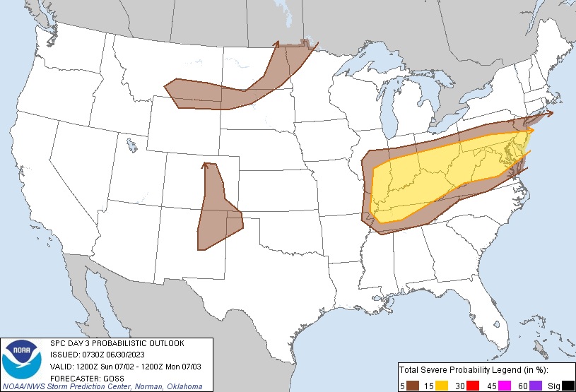
It is likely severe thunderstorms will be making a return to the Mid Atlantic on Sunday along with the possibility of isolated tornadoes. In a Severe Thunderstorm Outlook issued by the National Weather Service’s Storm Prediction Center (SPC) today, meteorologists there have highlighted an increased risk of severe storms for portions of southern New Jersey, all of Delaware, most of Maryland and West Virginia, northern Virginia, southern Ohio and Indiana, southeastern Illinois, almost all of Kentucky, and portions of northern Tennessee.
The SPC is blaming a mid-level trough for the expected weather trouble. A mid-level trough across the Ohio Valley and into the Northeast is expected to progress east on Sunday while a rather ill-defined surface baroclinic zone shifts slowly across this region. A moist and destabilizing airmass along and south of the surface front will contribute to development of afternoon storms, some of which will become severe. The SPC says that some storms may organize locally into fast-moving clusters, accompanied by damaging winds, in light of a belt of strong westerly flow through the lower and middle troposphere that is progged to reside atop the region. And while daytime heating will help fuel the storms during daylight hours, storms will likely continue after dark, spreading eastward into the Mid-Atlantic region Sunday evening, along with the threat of severe elements such as large hail, damaging wind gusts, and isolated tornadoes.

It is still too far out to know where the greatest risk of tornadoes will be on Sunday and how strong they may become.
When tornadoes do form, they are rated on an EF scale. The Enhanced Fujita Scale or EF Scale, which became operational on February 1, 2007, is used to assign a tornado a ‘rating’ based on estimated wind speeds and related damage. When tornado-related damage is surveyed, it is compared to a list of Damage Indicators (DIs) and Degrees of Damage (DoD) which help estimate better the range of wind speeds the tornado likely produced. From that, a rating (from EF0 to EF5) is assigned. In general, EF-0 tornadoes have 65-85 mph winds, EF-1 have 86-110 mph winds, EF-2 have 111-135 mph winds, EF-3 have 136-165 mph winds, EF-4 have 166-200 mph winds, and EF-5 tornadoes have winds in excess of 200 mph. The EF Scale was revised from the original Fujita Scale to reflect better examinations of tornado damage surveys so as to align wind speeds more closely with associated storm damage., with the new scale related to how most structures are designed.
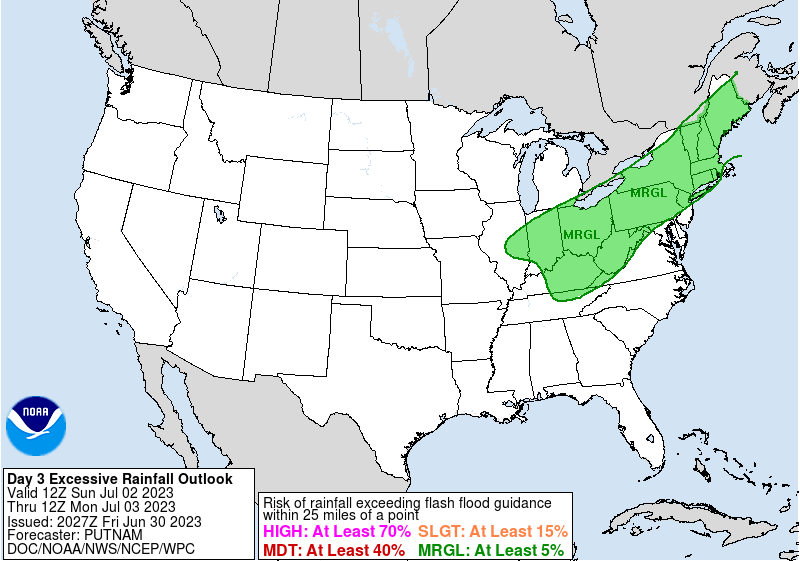
In addition to severe storms, there could also be very heavy rain which could lead to flooding issues in portions of the Northeast and Mid Atlantic. According to the National Weather Service’s Weather Prediction Center, an additional surge of moisture northeastward ahead of the approaching upper-level trough over the Northeast will usher in even higher precipitable water values than Saturday, with forecast values as much as 2 standard deviations above normal. As a result, a risk of heavy rainfall and the potential for flash flooding will linger later Sunday into the start of the new week due to this weather system set-up.
