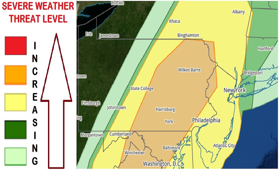
Severe thunderstorms with damaging winds, hail, and tornadoes continue their march this evening into portions of Pennsylvania, New York, New Jersey, Maryland, Delaware, and Virginia. The storms have already sparked numerous Tornado Watches and Warnings and Severe Thunderstorm Watch and Warnings.
The National Weather Storm Prediction Center (SPC) has been warning of this threat of severe weather since Sunday, giving people ample time to prepare for the rough weather. In addition to isolated heavy pockets of rain and frequent lightning, the SPC says winds could gust to or over 70 mph from these storms, hail can be the size of marbles, and a few tornadoes could form within the most severe cells.
Severe storms are in central and eastern Pennsylvania right now and will continue to slide to the East. Between 7-10pm, the storms will arrive from west to east over Philadelphia and northwestern New Jersey. By 10pm-midnight, the storms will reach the coast. Atmospheric conditions don’t appear to support severe weather over much of Long Island east of New York City; as such, the threat of severe weather should dissipate once the line hits the Jersey Shore later tonight.
According to the SPC, skies have remained relatively clear across parts of central/eastern Pennsylvania ahead of a line of convection that has shown increase in coverage and lightning activity. Surface observational trends have also shown a localized area of pressure falls ahead of this activity. Damaging wind gusts and isolated marginally severe hail will remain a concern as these storms continue eastward. The SPC says that given the backed surface winds in eastern Pennsylvania and other atmospheric winds that should remain strong to the east, there will also be a threat for quasi-linear convective system (QLCS) circulations and tornadoes. This severe threat will move into New Jersey and southern Upstate New York before midnight tonight; beyond midnight, the threat should be over.
The greatest severe hazard from these storms will be from straight-line winds. While there will be isolated tornadoes, straight-line winds can create tornadic-like wind damage. According to the National Weather Service, bow echo-induced winds and downbursts from QLCS account for a large majority of the structural damage resulting from convective non-tornadic winds.
RADAR of these storms moving along can be found here: https://weatherboy.com/RADAR/
